
Defenses of Washington – in Arlington Co., VA (July 2009)
Arlington County is fortunate to own the historic remnants of a small Civil War fort as part of a 19-acre acquisition from a private landowner in 1994. In addition to the historic fortification the park includes the restored Hendry House that is available for weddings and other events, and a half-mile interpretive walking trail through the woods, past gardens and around the fort.
The park is located at 2411 N. 24th Street (map) in a quiet residential neighborhood near the confluence of Interstate 66, Spout Run Parkway and the George Washington Memorial Parkway. There is plenty of off-street parking available in their lot assuming an event isn’t in progress which is generally the case. Perhaps Saturdays in June when the wedding season is in full swing might provide a few parking challenges but other than that we’ve rarely seen more than a handful of cars in the lot.
Defending Washington
Washington, DC, the capital city of the United States, found itself in a precarious situation when the Civil War broke out. Virginia — just across the Potomac River — joined the Confederate States of America in April 1861 after the Battle of Fort Sumter. This placed Washington within a river’s width of enemy territory. The Union Army marched into these borderlands immediately and seized them in order to create a buffer which they held for the duration of the war.
They built a series of fortifications entirely around the city to establish a protective perimeter. This grew to 68 forts along with numerous detached batteries, rifle pits and blockhouses, involving tens of thousands of soldiers. Collectively these became known as the Defenses of Washington. Arlington County contained 22 of these forts, with C.F. Smith the best preserved in the Arlington today.
The Naming of the Fort
Fort C.F. Smith, constructed hastily on a hilltop in north Arlington, formed one small part of this protective circle. But who was C.F. Smith and how did he happen to have a fort named in his honor? Charles Ferguson Smith had been a career military officer with a distinguished record. He served extensively during the Mexican-American war and therefore had prior combat experience before the Civil War exploded. He attained the rank of Major General by that time and he became on of General Grant’s favorites.
While on campaign in Tennessee he injured his leg while jumping into a rowboat. Although the injury itself wasn’t life-threatening, infection set in and killed Gen. Smith at a time when the Union army desperately needed his experience. They would pay dearly for this at the Battle of Shiloh.
The Defenders
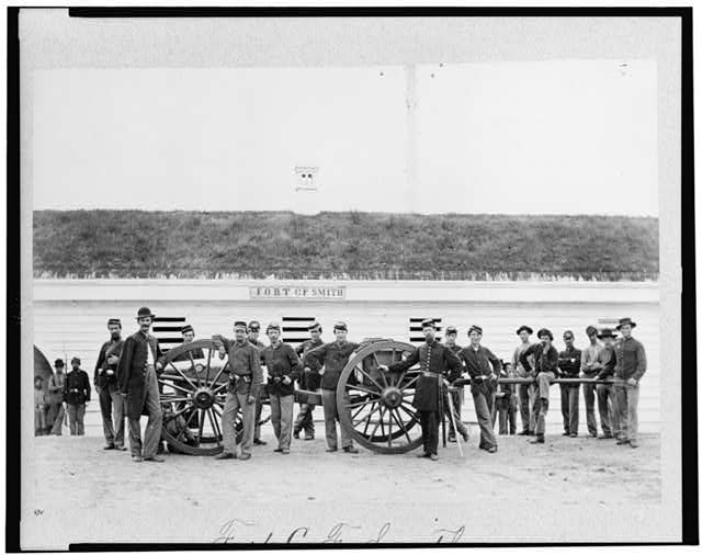
Company L of the 2nd New York Artillery served at Fort C.F. Smith. Here they pose in this public domain image available from the Library of Congress. Some might think that these were the lucky ones, and perhaps they were when compared to their brethren who slogged from one horrible battlefield confrontation to another.
However the fate of a great city fell into their hands and they had to be prepared constantly. Indeed, one spot along the defensive circle was attacked during the war: Fort Stevens received a direct blow from Confederate troops under Lt. Gen. Jubal A. Early in 1864, bringing the war to the edge of the District of Columbia and physically within its boundaries. The capital could have been sacked if the perimeter had faltered.
Design
Fort C.F. Smith was constructed in 1863 to combine with other nearby forts to extend the defensive line in Arlington all the way to the Potomac River. The land had been privately owned but it didn’t matter. The army appropriated the Jewell family farmstead for the duration of the war and returned it once the conflict ceased.
Specifically the fort and its companions stood guard to protect the Aqueduct Bridge of the Chesapeake and Ohio Canal. The Aqueduct Bridge over the Potomac interestingly enough was a bridge for canal boats to travel above the river between the C&O and the Alexandria canals. Indeed it was a water-filled bridge, and important to commerce in the District of Columbia.
Lunettes
Civil War forts of this style are known as “lunette” fortifications, deriving from a French word meaning “little moon.” A lunette refers to its shape, specifically a half-moon. Artillery could be placed along the arc of the half-moon to cover attacks coming from a wide field of directions. Fort C.F. Smith had two such lunettes, one facing south and the other facing west, the most likely directions of attack.
It also included two bastions or protrusions on the northern side just in case enemies were foolhardy enough to climb the steep bluffs leading up from the Potomac valley, below. The entrance was located on the eastern side as were all the buildings that support the daily lives of the troops including a barracks, kitchen, officers quarters and stable.
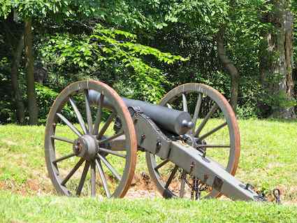
The lunettes were designed to hold four 8-inch siege mortars and 22 artillery pieces. All the mortars were installed but only 16 of the artillery pieces were actually placed: two 6-pounder brass guns, six 4.5 inch guns, four 24-pounder cannons, three 12-pounder howitzers, an 8-inch seacoast howitzer. Ramps lead up to wooden platform upon which the artillery rested.
Physical Barriers
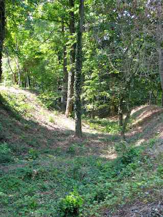
Defenses were layered upon defenses. The builders constructed a large ditch or moat along the perimeter and beyond that a glacis leading up to the artillery stands. The ditch contained all sorts of obstacles. In this manner attackers would have to cross an open field, descend and then climb out of an obstacle-filled ditch and finally climb the glacis to force their way into the fort, all while under a constant barrage of heavy artillery and rifle fire.
The Union Army decommissioned Fort C.F. Smith barely two years after they constructed it. It became instantly obsolete when the war ended in 1865. They proceeded to remove the most visible signs of their presence, the buildings, weapons and other accoutrements of war. The ditches were about all that remained.
Preservation
While most of the old forts in the ring fell to urbanization and development over the next nearly century and a half, Fort C.F. Smith remained primarily as it had when it was returned to the Jewell family. Few others owned this particular property over the years and the historic portions left behind as scars upon the terrain remained generally intact.
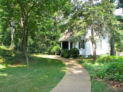
The primary buildings in existence on the property today, the Hendry House and the cottage date to the post-war period. Dr. Ernest S. Hendry purchased the property in 1927 and his family owned it until 1994. At that time Arlington County acquired the estate and turned it into a public park.
Modern Usage
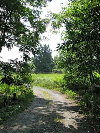
The county uses this facility to provide multiple uses. Certainly there is the historical aspect. In addition there is a half-mile walking trail around the northern edge, stretching from meadow through forest. One would hardly know that the GW Parkway is barely a stone’s throw away while walking along the path. It looks like it’s way out in the country and many miles from anywhere, but it’s really a rural oasis set amid a close-in suburb of a major city. The meadow attract birds and mammals alike, and a rich variety of plants thrive on this dividing line between Piedmont and Coastal Plain.
The Hendry House is a 2,900 square foot Victorian structure built in phases throughout the 20th Century. The public can rent space for meetings, events and wedding receptions. It’s hard to imagine a more peaceful place for an event, a direct contrast to how this land would have appeared in 1863.
Readers who have an interest in forts might also want to check my Forts, Fortresses and Fortifications page.
Leave a Reply