Florida I-10 Time Zone Crossing

I’ll bet you’re checking your phone right now, driving along Interstate 10 in Florida and wondering where the time changes. I think I can help you. It happens between Mile Markers 160 and 161.

So that should do it. That’s the nice simple answer and now you’ll know when to adjust your watch. On the other hand, a small number of readers might want some additional context. Maybe learn some fun facts? And what’s the difference between a normal fact and a fun fact, by the way? Unfortunately I can’t help with that last one.


The Setup

I was genuinely shocked with the popularity of the Tennessee I-40 page I created a few weeks ago. Then I started noticing a number of new queries on the site that referenced I-10 in Florida. I can only guess that there’s minimal information about this little niche subject on the Internet.

Like, who cares where the time changes along a highway? Well, apparently, a lot of people. So I’ll try this again but with I-10 and maybe create additional pages for other states and highways if the need arises.

In Florida, water defines a split between Eastern and Central Time. From the north, the Chattahoochee River separates Georgia from Alabama for much of their shared border. Georgia follows Eastern Time and Alabama follows Central Time. Then this same distinction continues as the Chattahoochee forms part of the Florida border.

Ditto when the Chattahoochee joins the Apalachicola River and cuts through the Florida panhandle. One side of the river follows Eastern Time and the other follows Central Time. Interstate 10 crosses the Apalachicola River about 40 miles west of Tallahassee so that’s where the time changes.

Florida is a really long state. It’s no surprise the time has to change somewhere along the way. So watch for the river and let that serve as your guide.


Westbound (going from Eastern to Central Time)

Entering Central Time Zone on I-10, Florida. Image from Google Street View; July, 2019.

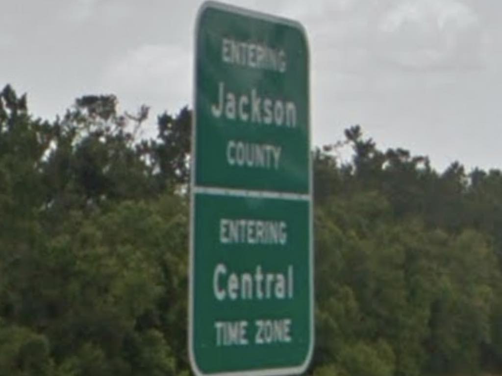
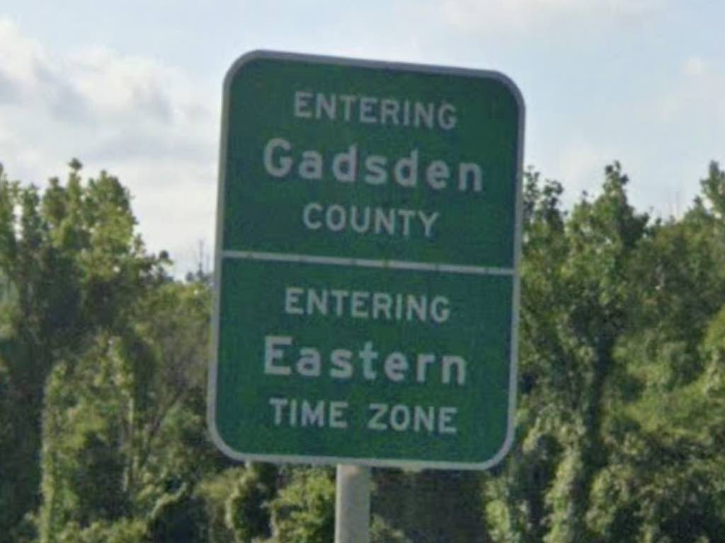
The river is great for marking other things too, including county boundaries. Along I-10, this means someone crossing the Dewey M. Johnson Bridge will transition between Gadsden and Jackson Counties.

But who was Dewey Johnson? Fortunately Wikipedia has an answer for everything and it turns out that the bridge honors Dewey Macon “Nick” Johnson. He was a minor Florida politician back in the 1940’s, 50’s and 60’s. He wasn’t particularly noteworthy, but then again neither is the bridge. Nonetheless, it’s one more thing than has ever been named for me so good for him. Johnson lived about 20-miles away from the bridge and everything seemed fine.

Also, beauty is in the eye of the beholder. The bridge didn’t impress me particularly but Bridgehunter had some nice words:

“The Dewey M. Johnson Bridge is noted for being an example of the haunched deck plate girder design, which outside of the state of Arkansas which built them in abundance, are one of the more uncommon types of girder bridges.”

So there you go. Be on the lookout for those rare haunched deck plate girders. I’ve actually driven across it too, most recently going westbound a few years ago as I drove between Jacksonville, Florida and the Mississippi Gulf Coast.


Eastbound (going from Central to Eastern Time)

Entering Eastern Time Zone on I-10, Florida. Image from Google Street View; April, 2021.

The time zone boundary is really quite simple here. However, things get bizarre a little further south along this line. Sometimes that happens when a border follows a natural feature such as a river. There is a Florida town called Overstreet (map) in Eastern Time that is surrounded on three sides by Central Time. But that’s not a worry here along Interstate 10 where a river, a county line and a time zone all come together.

Comments

7 responses to “Florida I-10 Time Zone Crossing”

  1. Gary Avatar

    When my wife and I went to New Orleans back in 2017 for our 20th anniversary, we crossed the time zone line at this point. Just to the east of the line (crossing into Eastern Time) is a rest area. It was cool how about a mile or two before it was an hour earlier by the clock. Going west, the rest area is just before the boundary. There isn’t one after you cross the line until about 45 miles later.

    We are planning on going back to NOLA in October for our 25th. It is roughly an 11 hour drive going straight through from here where I live in the Orlando area. But we didn’t do all of it in one day. Going there we stopped for the night in Mobile Alabama, and coming back we stopped about 30 or 40 miles east of Tallahassee. I did add three states to my list of states been to – Alabama, Mississippi, and Louisiana. Something like 35 states and three Canadian provinces I have been to.

  2. Christopher Archuleta Avatar
    Christopher Archuleta

    I have thought about time zone changes on the highway before. I remember telling myself that the change on I 65 in Indiana is in a wind farm.

  3. Gary Avatar

    I know I had already replied but figured I would do another one after just going through there. My wife and I went to New Orleans for our 25th anniversary (which was October 18) and drove through that area twice – going there and coming back. Going there, we stopped at the rest area just before the line and had our lunch. I happened to look at my phone and the clock on my cell phone said 11:15, even though it was 12:15. It must have gotten its signal from a tower in Central time, henceforth the hour difference.

    We ate, got on the road again and stopped at exit 131 for gas. It was 11:45. Funny how at about 12:30 by the clock we were eating lunch 30 miles before that!! Coming home, we did not stop at that rest area and just went right on through. It was a few miles into Eastern Time when my phone finally changed.

    I will say that part of Interstate 10 has some of the strangest rest areas I have ever seen. The one at the time zone line (just before the line going west, and just after the line going east) only has one rest are for both directions on Interstate 10 on the eastbound side of the road. Westbound traffic has to cross 10 to get to the rest area. At mile 96 there is another rest area, but one must use exit 96 and get off the highway to access the rest area. The others on 10 are normal (one west, one east).

  4. Craig Avatar
    Craig

    I’ve been trying to find this info for awhile.

    Thank you!

  5. Derf Nosneb Avatar
    Derf Nosneb

    I go back and forth across the river several times a day and have only aged a few days in the last five years.

  6. Cynthia Dean Avatar

    Thank you for this article, We are headed West From the Village headed back to Mississippi. I found the information very helpful and interesting.

  7. jill browne Avatar
    jill browne

    Many of these comments are very interesting, have enjoyed reading. We cross several times a year as well going from dallas to sebring. There is slight time delay for clocks to change. But we were just wondering how much longer we were waiting on the change when I came across these posts. Have enjoyed them all but mostly the person who said he was just cpl years older from crossing so many times and the cpl on thier 25th wedding anniversary. Ty

Leave a Reply

Your email address will not be published. Required fields are marked *

Latest Comments

  1. Technically it’s not always correct to say EST/CST, etc…. but just an indication that I’m changing time zone is enough,…

  2. In general, I wonder why navigating from the Atlantic Ocean to the Black Sea doesn’t count as inland navigation.

  3. Re: East/West Carroll parishes, you’re close, but the real reason for the split was more political than demographic or cultural.…