
The summer flew by so quickly. It seems like only yesterday that I drove to Michigan to pick up the kid from college after the end of the spring semester. It was a great trip and I managed to collect eight previously unvisited counties in Ohio along the way. But now I was doing the same in reverse, and returning the kid to Michigan for the fall semester. So of course I used it as a chance to chip away at more Ohio counties to add to my county counting list.
We took the fast way up, the all too familiar Pennsylvania and Ohio Turnpike route. I didn’t need to make the kid suffer through another round of rambling along rural byways. Now unencumbered, that was my exact intent for the drive back home.
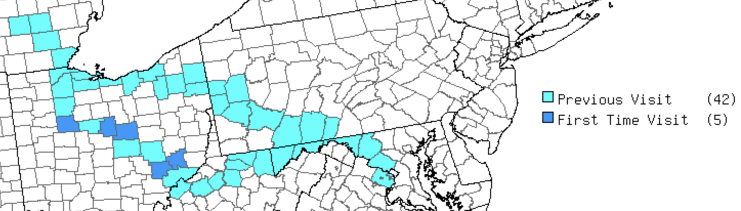
My prior efforts, both the most recent drive to Michigan and an earlier trip to Dayton captured a bunch of Ohio counties. However, those efforts were not entirely precise. I’d left some unsightly doughnut holes behind that now needed filling. That explains the scattered nature of the “First Time Visits” colored on the graphic.
It was a delightfully inefficient path that turned a nine hour drive into a twelve hour drive, with an overnight stop around the halfway point. The diversion created something of an arc around the northern and eastern sides of Columbus, Ohio that’s easier to see on a Google map than to describe.
The route extended from about 11:00 to about 4:00 on a clock dial. Roughly, it ran through the towns of Kenton, Marion, Mt. Gilead, Mt. Vernon, McConnelsville, and finally to Caldwell along a short easterly spur. Thus, I added the counties of Hardin, Morrow, Knox, Morgan, and Noble to my lifetime tally. From there I hopped onto limited access highways (primarily Interstates) for the remaining journey home.
But Wait!
I’m getting a bit ahead of myself so let’s slow things down. I still had a couple of days in Michigan before embarking on the Ohio excursion. I guess another walk through the campus of Michigan State University would be worthwhile. I’ve seen it during every other season so I might as well check it out in summer too.
Michigan State

So that’s what I did. I’ve been up there a bunch of times as the kid completed a couple of undergraduate degrees and then an intial year of grad school. It’s mind-blowing to consider I’ve been doing this drive for five years now! This time we arrived a week earlier than most students because of the terms of the graduate program, and the campus was mostly deserted. I could even get a photo of the Spartan statue with nobody in the way.
Midtown Brewing

Then I had to find a new brewery because that’s what I do. Let’s pause for a second and reference the usual disclaimer. With that done, I’ll note I’ve already run through the entire list of East Lansing breweries. So I needed to go a little further abroad, all the way to… regular Lansing.
It’s just a few miles away but I’d never been to Lansing except while driving to the airport. So this marked my first get out of the car, put my feet down, and walk around town stop in Lansing, even if our sole activity involved dinner at Midtown Brewing. Don’t worry, I’ll hit some of the other Lansing breweries before the kid finishes grad school in May.
Wartime Trail

So let’s move onto the main event and talk about some Ohio county counting. I drove into position and arrived on the edge of Kenton, in Hardin County. My first waypoint was an historic marker along Hull’s Trail. Looking at all this open farmland it’s hard to imagine that this was untamed wilderness not so long ago. It was solidly within the middle of nowhere when the 19th Century began.
The newly-formed United States got into an altercation with the United Kingdom, a conflict unimaginatively called the War of 1812. Much of the fighting happened where American and British territorial interests overlapped, including the Great Lakes.
President James Madison ordered Gen. William Hull out to the Ohio frontier to assemble a militia force to march to Fort Detroit, where they would continue into Canada. The campaign was pretty much snakebit from the start. The militia lacked discipline, the march took longer than expected, Canadians resisted, and eventually the British captured Fort Detroit. Hull earned a court marshal and a death sentence for his role, but was saved by a presidential pardon. Later evidence showed that many of the issues were beyond his control and his reputation improved in the historical record.
Anyway Hull’s troops had to blaze a trail through the Ohio wilderness as they marched onward to Detroit, and it cut through present-day Hardin County. There are several markers set along the path here, made from the remnants of discarded columns from the old county courthouse. One of the markers appears in the photo (map).
Dead President

County counting brings me to weird places I would likely never visit otherwise. Case in point, why else would I stop at the tomb of a particularly discredited president? Warren G. Harding served from 1921-1923 until he died in office from a heart attack after traveling to San Francisco. He was popular during his term but afterwards the public learned of multiple scandals including Teapot Dome, and later his extensive philandering. He’s often considered amongst the worst presidents in United States history.
But he had a pretty spectacular tomb in his old hometown of Marion, Ohio (map). Supposedly one of his mistresses is buried in a cemetery right across the street so I guess that would be convenient in the afterlife.
Rust Belt Remnant

Much of my drive went through a portion of the country known for its rapid deindustrialization during the latter part of the 20th Century. Manufacturing declined and jobs migrated to cheaper places primarily overseas, leaving abandoned factories behind. Colloquially, what people once proudly called the Steel Belt quickly became the Rust Belt. I found one such remnant in Mount Vernon, Ohio. I wrote an article about a town called Mount Vernon many years ago, but not this one. Nonetheless, I’m always happy to add a new Mount Vernon to my list and this was a fine specimen.
This Mount Vernon once included the largest factory of its kind in the world, a sprawling industrial complex of more than a million square feet, opened by the Pittsburgh Plate Glass Company in 1907. Then the usual Rust Belt story unfolded and the factory closed in 1979. Mount Vernon could have simply bulldozed the whole site but they did something different. They created the 250 acre Ariel-Foundation Park.
The park includes the preserved ruins of several brick buildings, along with walking trails, outdoor artwork, an event center, and a museum (map). However the centerpiece is a 280 foot smokestack that previously vented gases from large-scale industrial glassmaking. They even took it a step further: a spiral staircase wraps halfway up the old smokestack to an observation desk. The whole conglomeration is called the Rastin Observation tower.
Yes, we climbed to the top and the views of the park and the town and the surrounding countryside were wonderful. I love lighthouses, and while this certainly isn’t a lighthouse, it was close enough for me. I enjoyed this industrial version far away from the nearest coastline and I tip my hat to the fine residents of Mt. Vernon for their foresight.
That seems like enough words for now. I’ll talk about the rest of the drive in Part 2.
Leave a Reply