
Belle Chasse, Plaquemines Parish, Louisiana (April 2010)
I’ve been to the New Orleans area on numerous occasions but somehow the Belle Chasse Ferry in Plaquemines Parish had eluded me. Finally I made a special effort, traversing the Crescent City Connection bridge towards the West Bank, and drove down through the suburbia of Gretna before arriving at Belle Chasse (map).
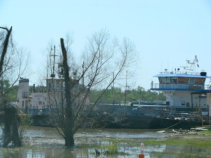
At first glance this ferry crossing would seem to be an anachronism. The bridge to New Orleans in less than ten miles away. However that would involve lots of driving through secondary streets with heavy traffic and numerous stoplights for the residents of this area, an arduous detour for people who simply want to cross from Belle Chasse to Scarsdale. The Mississippi River runs directly through Plaquemines Parish, cleaving it into two distinct and nearly equal portions. Were it not for the Belle Chasse Ferry and its counterpart further downriver at Pointe A la Hache, there would be no direct way to travel between the eastern and western sides of the parish.
Finding It
This is no romantic weekend tourist ferry, but a vital transportation transportation corridor both for the community and for commuters who live out in the country but work in the city. Employees of Plaquemines Parish, the school teachers, first responders, council members, all need to be able to get to parish offices and constituents on both sides of the river, and they use the ferry extensively. That’s probably why it’s not marked particularly well on the Belle Chasse side of the river. I suppose the operators figure it’s intended primarily for local use and the locals already know how to find it.
Just watch for the curve in the Belle Chasse Highway, and be sure to take Avenue “G” a couple of blocks down towards the wharf where queueing forms in two lines. It’s a much more obvious approach on the opposite, eastern, bank in Scarsdale. It’s extremely rural there and anyone can spot the road up the levee to the ferry landing, right near the intersection with the convenience store / gas station that exists to serve the passengers.
Crossing
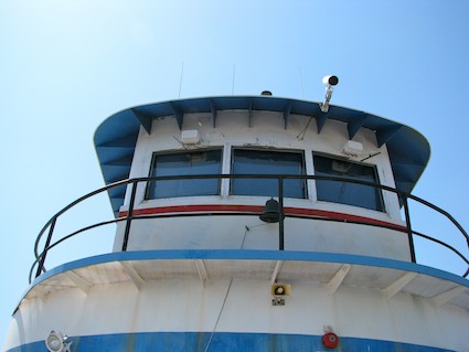
Several ships serve both the Belle Chasse ferry and its sister ferry further downstream, and travelers may find themselves on the Motor Vessel (M/V) Pointe a la Hache, Belle Chasse II, Louisiana or Plaquemines Pride. We loaded our car onto the M/V Pointe al la Hache on our trip across the Mississippi River that day. It’s hard to find a better bargain than the minimal fare. Where else can someone take a cruise for less than a cup of coffee? Regular riders can even buy a book of coupons and pay even less!
The cruise itself may actually be the shortest part of the journey lasting maybe a few minutes. It probably took even less time than loading all of the cars and trucks onto the ferry in the first place when we boarded on the Belle Chasse side of the river. It runs every half-hour during the middle of the day, at the top and the bottom of the hour on the west bank, and lines began to form well in advance. The deckhands chatted amiably with riders, obviously regulars, and we soon found ourselves on the opposite bank. There wasn’t even enough time to get out of the car and look around. We found ourselves docking in Scarsdale before we knew it.
Better Than a Bridge?
Three New Orleans-area ferries (Belle Chasse included) have a combined operating cost of around $7 million while generating less than $250 thousand in tolls according to the The Times-Picayune. So why not simply build a bridge? As large as those numbers sound, it’s still a lot cheaper to operate the ferries.
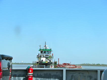
There are incredible amounts of freighter and barge traffic running past this point on their way to and from the Port of New Orleans. A bridge would have to be designed and constructed high enough to allow the frequent large ship traffic to pass. It would have to look something like the Crescent City Connection, and that would be horribly expensive and highly impractical given the population characteristics of the area. There simply are not enough people especially on the east bank to make it feasible.
It’s natural to wonder what happened to the ferry during Hurricane Katrina. I wondered that myself after leaving the ferry as I drove back towards Interstate 10 through St. Bernard Parish, noticing the storm damage that was still visible several years later. From what I could find, the area where the ferry operates seemed to have escaped the worst of the high winds and flooding, and the ferry went back into service soon after the hurricane. It will probably continue to serve as a vital link for many years to come.
Readers who have an interest in ferries might also want to check my Ferry Index page.
Leave a Reply