
Beaver Island, Michigan, USA (September 2000)
One small town existed on Beaver Island — St. James — and barely a couple hundred people lived there. The remaining several hundred residents spread broadly across the island. Essentially, almost every view involved a rural scene around here.
Hiking
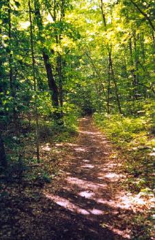
Miles of hiking trails literally covered Beaver Island. Many of them followed old logging roads and rail corridors. Nineteenth and early Twentieth Century residents used them to transport timber from remote corners of the island to St. James. Steamships docked to refuel there, purchasing logs to heat their boilers. Beaver Island’s location at the northern end of Lake Michigan made it a convenient stopping point for ships destined to and from ports such as Milwaukee and Chicago.
The Kuebler Trail followed an old railroad grade on the northwest side of the island, north of the airport (map). We began at the Protar’s Tomb trailhead. Feodor Protar had been a much-beloved local character and a bit of a recluse who always went out of his way to help everyone he could. His friends built a tomb for him after he passed away in 1925. The trailhead also included a memorial to a fatal 1908 logging train wreck that took place nearby.
From here the trail cut north through thick forest until it arrived at the coastline, upon a flat open plain called McCauley’s Point.
From the Past
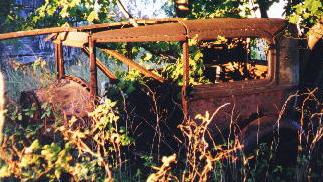
We stumbled onto all kinds of interesting items during our hikes around the island. As we prodded along Sloptown Road in the north central part of Beaver Island we came across an abandoned automobile rusting into the underbrush (map). I had no idea how to decipher the make and model, but it looked like a sedan out of a 1930’s gangster movie. I could almost imagine bootleggers firing from the windows with Tommy Guns, although I doubt anything that extreme ever happened here. More than likely a local farmer used it until it couldn’t be repaired any further and then ditched it in a remote corner out of sight.
In a sense it seemed logical to find abandoned automobiles, logging equipment, farm machinery and other large consumables in this remote location. It would be easier to leave something in the woods and let it return to nature rather than drag it all the way to a salvage yard on the mainland for a few dollars as scrap.
Farther Afield
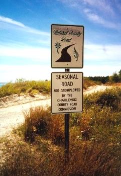
Beaver Island didn’t have a lot of residents, but it got increasingly empty as we traveled farther south from St. James. Iron Ore Bay sat at the island’s southern extremity and practically nobody lived there.
It’s not difficult to reach and it can be combined with a visit to the Beaver Head lighthouse and Fog Signal Station. The road was amazing. It was a dirt track, not gravel, cutting through dunes with unobstructed panoramic views of Lake Michigan. We found a public beach at Iron Ore Bay and stopped for a picnic (map). Maybe one or two cars passed through here during the entire time.
Readers who want to see more about Beaver Island can check my Beaver Island Index page.
Leave a Reply