
With niceties out of the way including a few hours at Niagara Falls, I could focus on the primary purpose. Three more New York counties needed my attention: Wyoming, Cattaraugus, and Allegany. Collectively they created a significant doughnut hole on my map. Obviously that wouldn’t do so I drafted the most efficient route to grab them.
Snagging New Counties
Fortunately I could draw something of a straight line between the three. Sure, the course involved a few back-roads but I’ve done plenty of that before.
I felt a tiny bit guilty because I just barely clipped Wyoming and Cattaraugus Counties. Those are the two intermediary waypoints on the embedded map, above. So that’s how it goes sometimes in the County Counting business. Some get an overnight stay and some get barely an afterthough. Also it’s always possible I could explore them more thoroughly in the future so there’s still hope. That’s happened before, too.
Bonus Brewery
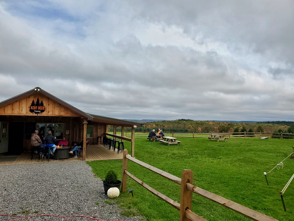
The drive down from Niagara Falls unfolded uneventfully. During my planning I noticed a small brewery near our intended overnight destination. Even so, I never added it to the list because I didn’t think we could get there before it closed.
Anyway, as we drove along my wife said, “you know, we could probably get there 15 minutes before last call if we don’t stop.” We were already running much lower on fuel than I prefer and I was starting to look for gas stations. But I did a quick mental calculation and I figured we could make it with a little room to spare.
We arrived at Kent Beer Company (map) at 4:45, just like Google Maps predicted and we had just enough time to split a small sampler. It was a gorgeous farm brewery, set among rolling autumn-colored hills. It also sat across the road from a large All-Terrain Vehicle park with a surprising amount of 4-wheeler traffic driving down the gravel road. This would be a great way to end the day if I ever rode an ATV. Which I don’t. Maybe in the next lifetime.
Hann Homestead
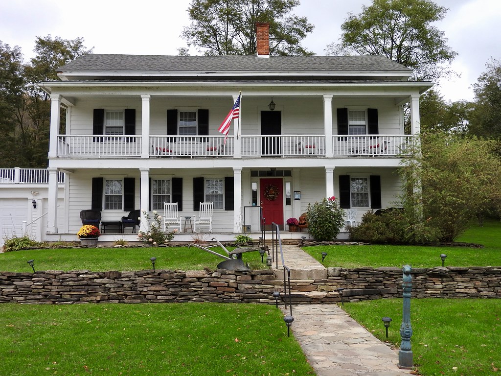
Many years ago, my wife (then fiancé) and I went on a tent camping trip through New England. However, once she got that wedding ring she announced she didn’t like camping anymore. From there on out we stayed primarily at Bed and Breakfast inns. Then came children and the primary requirement shifted to whatever chain hotel offered an indoor pool. Now, with one kid away at college and the other old enough not to care about a pool, we had a lot more options. After all those years a B&B sounded pretty nice again.
We stopped at the Hann Homestead Inn near Amherst, New York (map). It was just a mile from the brewery, so I call that a bonus. I also added Allegany County to my list, not simply as a new county visit but as a new overnight county. Hey, these things matter!
Quite the Welcome
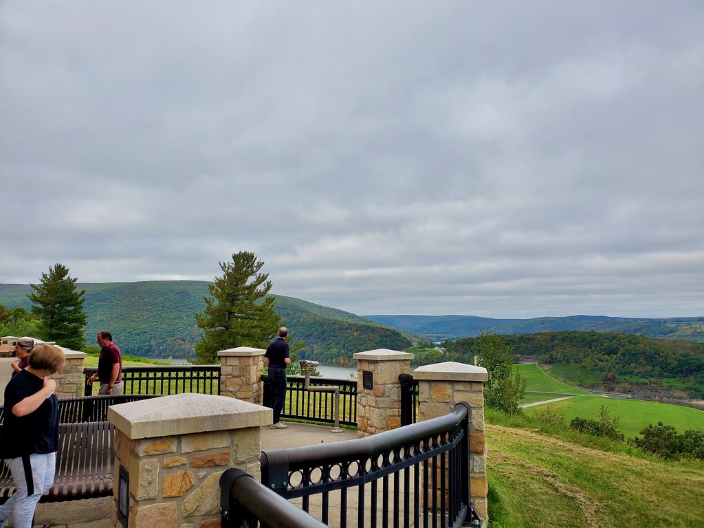
Only the drive home remained on Monday morning and we hit the road right after our B&B breakfast. We drove for awhile, crossed into Pennsylvania and stopped to stretch our legs. The rest stop at Tioga on Route 15 (map) seemed particularly nice, new and yes even scenic. It ran completely counter to the No More Rest phenomenon.
I think Pennsylvania built it in anticipation of this part of Route 15 joining Interstate 99 someday. Much of this segment already complies with interstate design standards. By the way, I-99 does not follow American Association of State Highway and Transportation Officials (AASHTO) numbering conventions. Its unusual numbering, and indeed its very existence traced back to a local congressman who wrote it into law as an ego project.
Heikes Covered Bridge
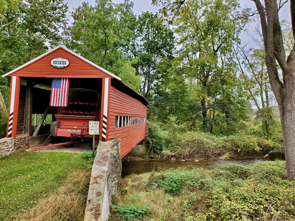
I wasn’t going to let a drive through Pennsylvania finish without visiting at least one covered bridge! So I did some homework ahead of time. Which bridge close to Route 15 could I visit with the least hassle? That turned out to be Heikes Covered Bridge between Harrisburg and Gettysburg (map). I don’t think it added more than about five minutes to our drive.
It crossed a local creek but the road network now bypasses it, leaving it stranded. So the bridge sits there as it has since 1892 although nobody uses it. Well, that’s not entirely true. The farmer who lives nearby converted it into a storage shed.
Detour
Everything worked so flawlessly that we were long overdue for a setback. Fortunately we anticipated that possibility. Traffic in the Washington, DC area is so bad that we always check conditions about an hour out. True to form, the most direct route down Interstate 270 from Frederick, Maryland wouldn’t do. Instead we remained on Route 15 down to Leesburg, Virginia and came in from the west. It seemed counterintuitive but it took less time, and more importantly the traffic moved.
Articles in the Niagara Weekend Series
See Also: The Complete Photo Album on Flickr.
Leave a Reply