
Only five of Pennsylvania’s sixty seven counties remained to be visited. They all aligned neatly to the west of our base in Clearfield. I felt pretty excited that morning. I knew I’d finish the statewide quest within the next few hours. Once again my older son decided to come along on the journey while the younger one preferred to hang out at the lake.
New counties encountered: Jefferson; Clarion; Venango; Armstrong; and Indiana.
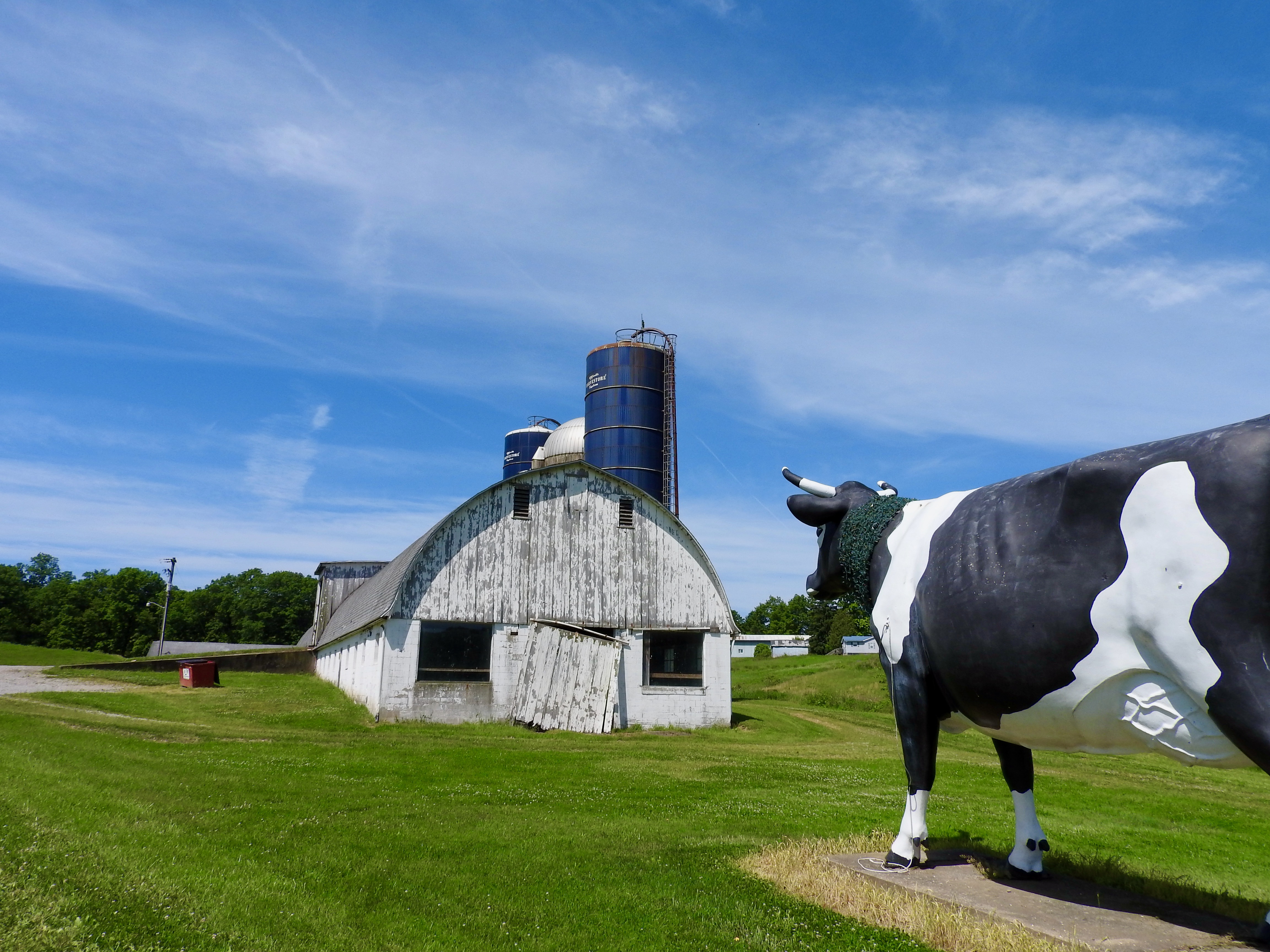
The Big Cow
We shot due west on Interstate 80, quickly capturing Jefferson and Clarion Counties. Then we exited at the town of Emlenton, clipping Venango County, and immediately crossed the Allegheny River briefly into Armstrong. I love Interstate counties! One hour of driving and now only Indiana County remained.
Not so fast! I still wanted to see a bunch of roadside attractions, the weirder the better. So the rest of the route wound back through those just-captured counties, meandering towards the last remaining one.
Back into Clarion County, the Big Cow beckoned near the town of Sligo (map). Literally, it was a big sculptured cow by the side of the road. A dairy farm commissioned the Big Cow in the 1970’s as an advertising gimmick. Unfortunately it must not have done its job because the dairy went out of business. Despite that, the Big Cow survived and continued to serve as a local landmark. It even had its own Facebook page. Visitors come from far and wide to pay homage. Actually I don’t know that. We altered our route ever-so-slightly to see it so I guess that counted.
Scripture Rocks
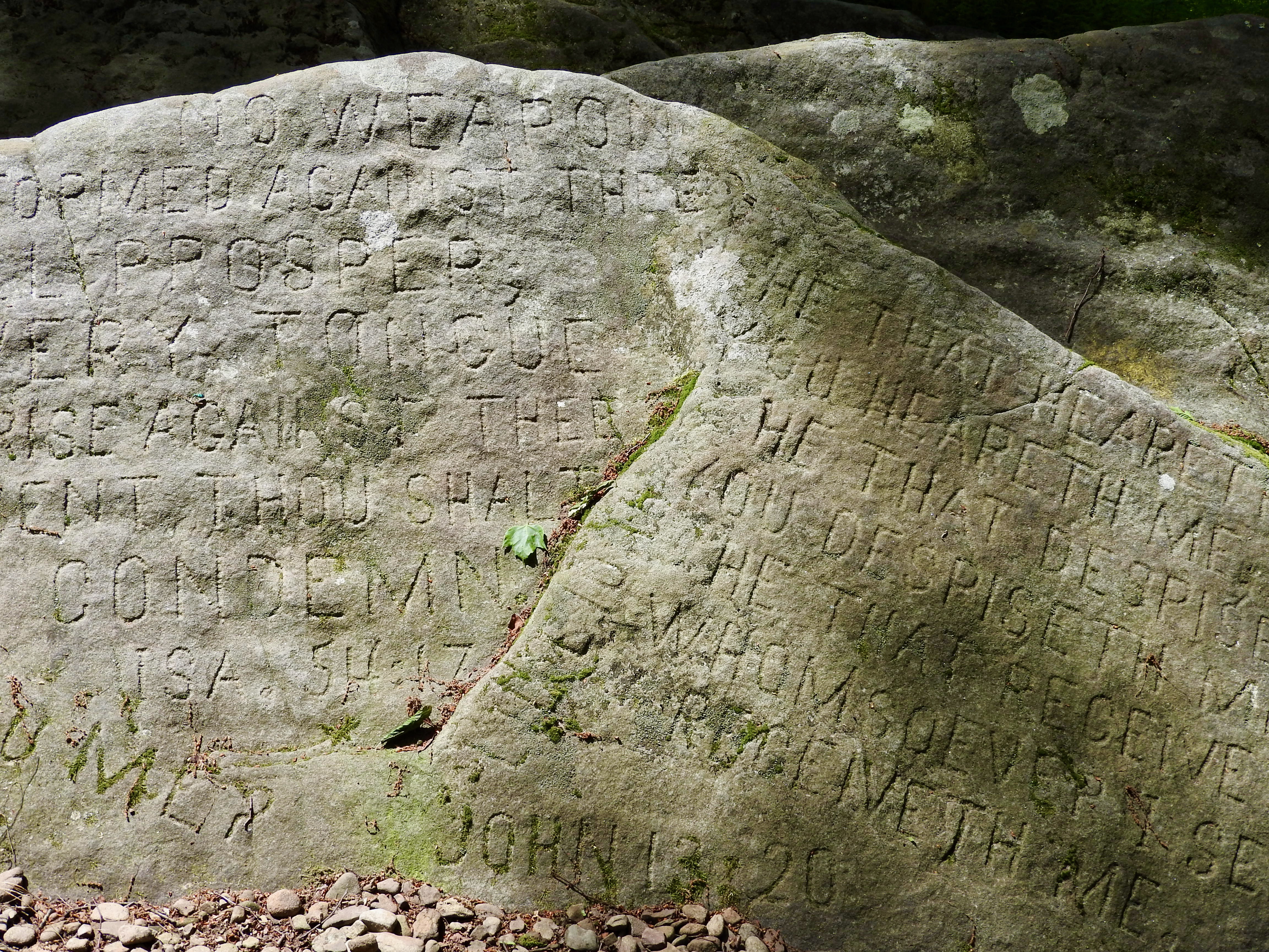
Carve graffiti onto every flat surface you can find and you might get into legal trouble. Do that in Jefferson County, Pennsylvania, and you might get an entire park dedicated to your works.
That served as the premise behind Scripture Rocks Heritage Park in Brookville (map). As usual, the actual story offered a more complicated truth. Douglas Monroe Stahlman carved biblical scripture along with religious commentary for several years of his life in the early 20th Century. He’d been involved in fringe religious movements and lost his wife to blood poisoning after trusting exclusively in faith healing. As a result, the government detained him briefly and took his children. He never quite recovered.
The majority of carvings appeared around 1911 – 1913, numbering several hundred in all. At one point he found a particularly picturesque jumble of stones and repurposed it into an outdoor chapel of sorts for his small group of adherents. The movement never really took hold. Stahlman lived much like a hermit by that time and he behaved strangely. Local authorities declared him insane and he spend the remaining two decades of his life in an asylum.
The park — a monument to a troubled man — preserved his works in an inspirational setting along forested paths.
Groundhog Day
We’d all heard the running pandemic gag, that being stuck at home day-after-day seemed like the premise behind the 1993 movie, Groundhog Day. What better place to visit during the present difficulties than the epicenter of Groundhog Day itself, Punxsutawney?
First I had to drive a couple miles south of town to capture Indiana County, though. With that, I tallied my final county and finished Pennsylvania. Now back to the groundhogs.
In Punxsutawney Proper

Punxsutawney seemed like such an odd name. Wikipedia said it came from the Unami language of the Lenape people, meaning “town of sandflies” or “town of mosquitoes” or perhaps “poison vine.” None of those sounded too appealing. I wonder what “town of groundhogs” would be in Unami?
Anyway, Punxsutawney knew where its fame came from and embraced it. Every available surface seemed to have groundhog artwork. Anthropomorphic statues of groundhogs in different outfits and poses graced downtown streets. We stopped at Phil’s Burrow (map), the home of the legendary weather prognosticator Punxsutawney Phil himself and showed our respects.
Out at Gobbler’s Knob

Then we ventured just outside of town to Gobbler’s Knob (map). This is the spot where Phil gets yanked into daylight every February 2. Winter will last another six weeks if he sees his shadow; otherwise an early spring will arrive. Never mind that his accuracy stinks. We care about tradition.
German immigrants brought their customs with them when they arrived in Pennsylvania in the late Nineteenth Century. Groundhog Day didn’t just appear, it had deep roots in a Christian festival, Candlemas. In Germany that came to be associated with badgers somehow. Pennsylvania didn’t have badgers so they improvised with groundhogs. I still don’t get the whole thing although it seemed harmless.
McGees Mills Covered Bridge
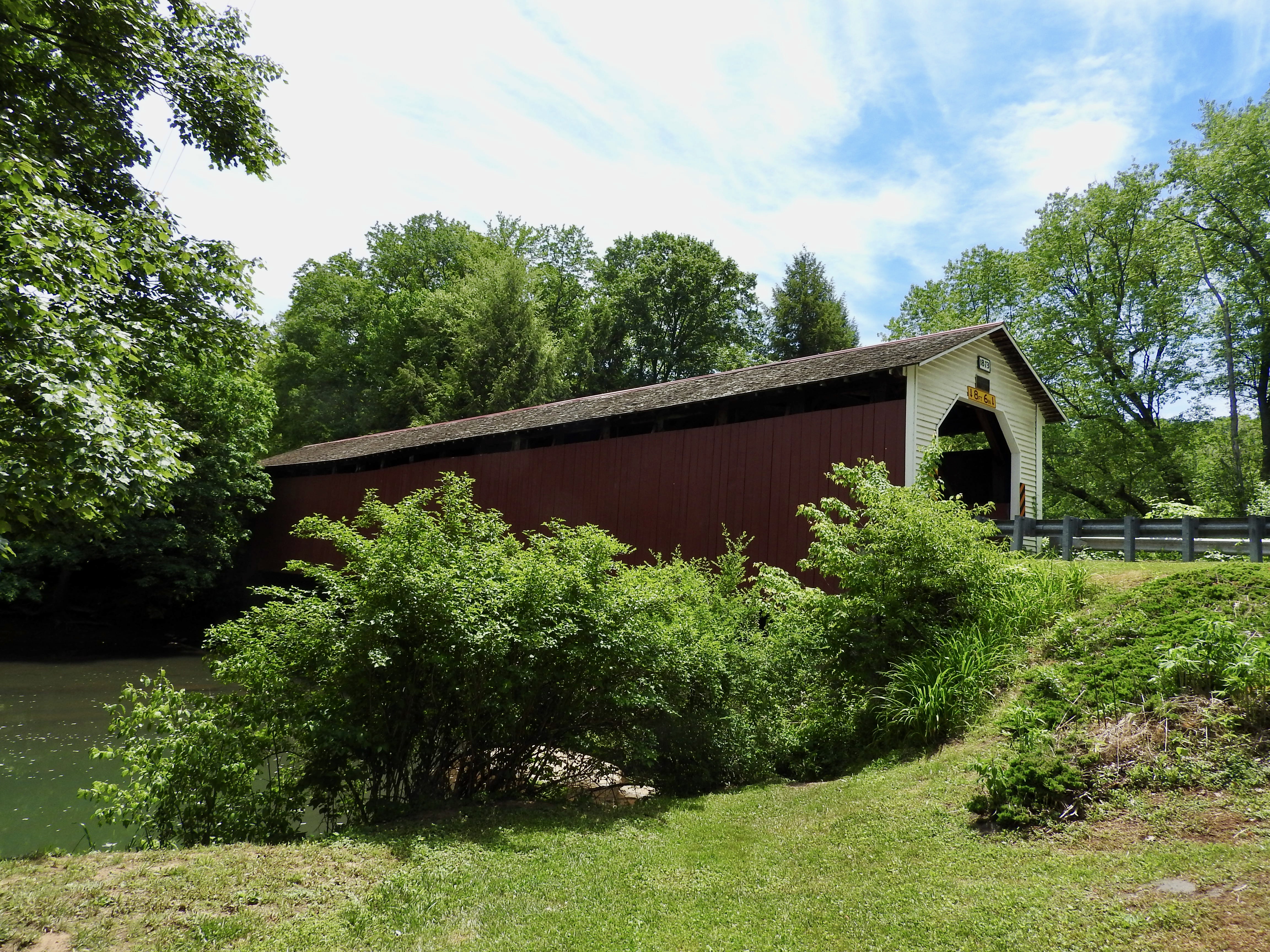
The final stop added to another one of my lists. Lots of covered bridges remained in Pennsylvania although not in this particular corner. In fact, I think McGees Mills Covered Bridge near Mahaffey (map) may have been the only one in any of the new counties I visited. It dated to 1873, a burr arch truss crossing the West Branch of the Susquehanna River. I drove across it a couple of times and headed back to our base.
I called the quest a success.
Articles in the Finishing Pennsylvania Series
See Also: The Complete Photo Album on Flickr
Leave a Reply