
There are 24 Counties in Maryland – “The Free State“
Also be sure to see my United States County Counting Page for the rest of the states.
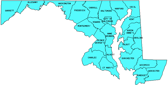
I have visited 24 Counties = 100% of Counties in Maryland
Counties visited are colored-in; counties still needing to be visited are blank. Map created using Mob Rule.
Twelve Mile Circle Articles Featuring Places in Maryland
Markers designate the Maryland locations featured in Twelve Mile Circle articles.
Interesting Maryland county trivia
- Washington County contains the narrowest point in Maryland. Here, the state practically pinches into two pieces with the distance across less than two miles at Hancock, where Interstate 70 and Interstate 68 join (map).
- The Town of Takoma Park used to be split between Montgomery and Prince George’s Counties. In 1997 the county border was moved to place all of Takoma Park within Montgomery County (map).
Counties in Maryland
Below are the 24 counties in Maryland. Although infrequent, counties sometimes do change so please let me know if any of this information is out of date and I will update it. Those counties that I have visited are highlighted in Red. Readers can also link to any articles manually in this section if the map isn’t working.
- Allegany: Uncle Tucker’s Brewhouse; Cumberland; Maryland Insterstate Adventure; Great Allegheny Passage; Savages; Frostburg Depot, WMSR; Mason & Dixon Line
- Anne Arundel: A Secret Revealed; DeKalb; Mistaken Identity; Chesapeake Bay Car Ferries; Reversible
- Baltimore: Simply Boring; Demolition Derby; Mistaken Identity
- Baltimore (Independent City): Double Duckpin; Last Place in the U.S.; Baltimore Brewing Company; Capitol City Brewing Company; Sisson’s / South Baltimore Brewing Co.; Wharf Rat; How Low Can it Go?; Vulnerable to Invasion; A Precious Tip; Where the Stadium Once Stood
- Calvert: Smallest county in Maryland (215 square miles); Calvert Marine Museum; Solomons Island; The Spots Not Covered
- Caroline
- Carroll
- Cecil
- Charles
- Dorchester
- Frederick: Largest county in Maryland (663 square miles); Frederick Keys; Brewer’s Alley Restaurant and Brewery; Frederick Brewing Co.; Point of Rocks Train Station; Journey Through Hallowed Ground; Canal Becomes Subway; Beltway Sniper Arrest; Utica Mills Bridge; Loys Station Bridge; Roddy Road Bridge; LeGore Bridge; South Mountain Welcome
- Garrett: Casselman River Bridge; Accident; Hoye-Crest
- Harford
- Howard: Delphia
- Kent: Smallest county population in Maryland (19,197 people in 2000 Census); Adjacent Counties, Same Name, Different States.
- Montgomery: Largest county population in Maryland (873,341 people in 2000 Census); Carderock to Georgetown; Gaithersburg Doughnut Hole; Growlers; Olde Towne Tavern & Brewing Co.; Summit Station; White’s Ferry; Poison Ivy Bench; Captains Less Prestigious; Playing Both Sides of the Street; The Degree Confluence Project; Bowls; Order in the Court; New Urbanism Viewed through Maps; International Latitude Observatories; Delphia; Duckpins!
- Prince George’s: Historic Fort Lincoln; A Secret Revealed
- Queen Anne’s: Chesapeake Bay Car Ferries; Reversible
- Somerset
- St. Mary’s: He Went Thata Way; Historic St. Mary’s City; Hollywood; I Call Bull Shark; Piney Point Lighthouse; Saint Marys River; Middling; Outside of California; Three Notches; Tippity Wichity
- Talbot
- Washington: Antietam Topography; Hagerstown; Hancock; Narrowest Point in Maryland; Sideling Hill; Williamsport; Wilson
- Wicomico: Evolution Craft Brewing Co.; Mardela to Delmar; Amazing Road Distances
- Worcester
Quick Facts About Maryland
- Location: Mid-Atlantic United States. See map above.
- Size(1): 9,707 square miles. Maryland is the 42nd largest state. The next larger state is West Virginia and the next smaller state is Vermont.
- Population(2): 6,042,718 people. Maryland is the 19th most populous state. The next more populous state is Missouri and the next less populous state is Wisconsin.
- Population Density: 622.5 people per square mile. Maryland is the 5th most densely populated state. The next more densely populated state is Connecticut and the next less densely populated state is Delaware.
- Bordering States: Maryland shares a border with 4 states: Delaware, Pennsylvania, West Virginia and Virginia.
- Admission to the Union: April 28, 1788. Maryland was the 7th state admitted to the Union, after Massachusetts and before New Hampshire.
- Capital: Annapolis.
- Highest Point: 3,360 feet at Hoye Crest on Backbone Mountain. See SummitPost’s Backbone Mountain page.
- Lowest Point: Sea Level at the Atlantic Ocean.
- Government website: maryland.gov.
- Official Tourism website: Visit Maryland.
- Still not enough? See Wikipedia’s Maryland page.
Sources:
(1) Wikipedia: List of U.S. states and territories by area. Land area only.
(2) Wikipedia: List of states and territories of the United States by population. Estimated population on July 1, 2019.
Leave a Reply