
There are 16 Counties in Maine – “The Pine Tree State“
Also be sure to see my United States County Counting Page for the rest of the states.
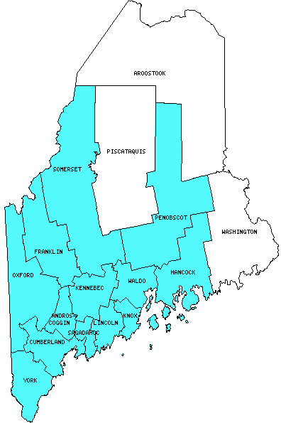
I have visited 13 Counties = 81.3% of Counties in Maine
Counties visited are colored-in; counties still needing to be visited are blank. Map created using Mob Rule.
Twelve Mile Circle Articles Featuring Places in Maine
Markers designate the Maine locations featured in Twelve Mile Circle articles.
Counties in Maine

Below are the 16 counties in Maine. Although infrequent, counties sometimes do change so please let me know if any of this information is out of date and I will update it. Those counties that I have visited are highlighted in Red. Readers can also link to any articles manually in this section if the map isn’t working.
- Androscoggin
- Aroostook: Largest county in Maine (6,672 square miles).
- Cumberland: Largest county population in Maine (265,612 people in 2000 Census); He Went Thata Way; Back to the Lines.
- Franklin: Rapid Transit in 1844; Mooselookmeguntic
- Hancock: Champlain Mountain; Sports Facilities I Never Imagined
- Kennebec
- Knox: Atlantic Puffin Colony; Franklin Island Light; Maine Lighthouse Museum; Marshall Point Lighthouse; Owls Head Light; Puffins, Seals and Lighthouses; Rockland Breakwater Light; Rockland-Vinalhaven Island Ferry; Birch Point Beach; Maine’s Rich Thai Heritage; Single Stone Across the Breakwater
- Lincoln: Eastern Egg Rock Puffin Colony; Geo-BREWities
- Oxford
- Penobscot
- Piscataquis: Smallest county population in Maine (17,235 people in 2000 Census); Appalachian Trail Counties.
- Sagadahoc: Smallest county in Maine (254 square miles).
- Somerset
- Waldo: Where’s Waldo?; Fort Knox State Historic Site; Fort Point Lighthouse; Fort Pownall; Penobscot Narrows Bridge & Observatory
- Washington: Infrequent Crossings
- York: Marginal Way; Isles of Shoals
Quick Facts About Maine
- Location: Northeast United States. See map above.
- Size(1): 30,843 square miles. Maine is the 39th largest state. The next larger state is Indiana and the next smaller state is South Carolina.
- Population(2): 1,338,404 people. Maine is the 42nd most populous state. The next more populous state is New Hampshire and the next less populous state is Montana.
- Population Density: 43.4 people per square mile. Maine is the 39th most densely populated state. The next more densely populated state is Oregon and the next less densely populated state is Utah.
- Bordering States: Maine shares a border with only 1 other state: New Hampshire.
- Admission to the Union: March 15, 1820. Maine was the 23rd state admitted to the Union, after Alabama and before Missouri.
- Capital: Augusta.
- Highest Point: 5,267 feet at Mount Katahdin. See SummitPost’s Katahdin page.
- Lowest Point: Sea Level at the Atlantic Ocean.
- Government website: Maine.gov.
- Official Tourism website: Visit Maine.
- Still not enough? See Wikipedia’s Maine page.
Sources:
(1) Wikipedia: List of U.S. states and territories by area. Land area only.
(2) Wikipedia: List of states and territories of the United States by population. Estimated population on July 1, 2019.
Leave a Reply