
There are 159 Counties in Georgia – “The Peach State“
Also be sure to see my United States County Counting Page for the rest of the states.
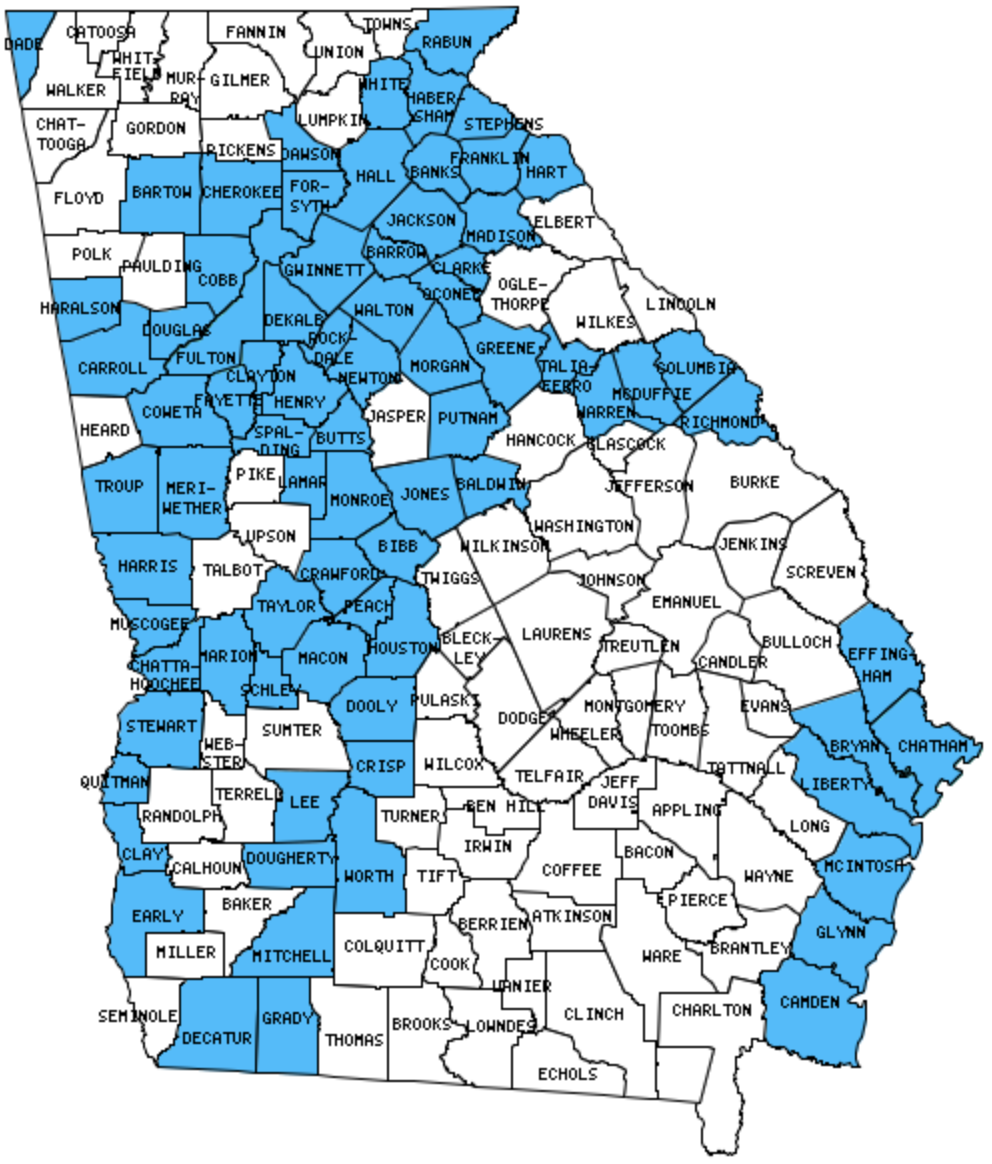
I have visited 78 Counties = 49.1% of Counties in Georgia
Counties visited are colored-in; counties still needing to be visited are blank. Map created using Mob Rule.
Twelve Mile Circle Articles Featuring Places in Georgia
Markers designate the Georgia locations featured in Twelve Mile Circle articles.
Counties in Georgia

Below are the 159 counties in Georgia. Although infrequent, counties sometimes do change so please let me know if any of this information is out of date and I will update it. Those counties that I have visited are highlighted in Red. Readers can also link to any articles manually in this section if the map isn’t working.
- Appling
- Atkinson: Georgia’s Enigma
- Bacon
- Baker
- Baldwin: Georgia Capitals
- Banks
- Barrow: Bought the Town; Quad County Towns
- Bartow
- Ben Hill: Full Names; Reconciliation
- Berrien: Georgia’s Enigma
- Bleckley
- Brantley
- Brooks
- Bryan
- Bulloch
- Burke: Mobley Swamp
- Butts
- Calhoun
- Camden: Saint Marys River
- Candler
- Carroll
- Catoosa
- Charlton
- Chatham: Fort Pulaski National Monument; Moon River Brewing Company; Nimby Lane; Savannah; Tybee Island Light Station; Savannah Globe Mural
- Chattahoochee
- Chattooga
- Cherokee
- Clarke: Smallest county in Georgia (121 square miles), Tree That Owns Itself
- Clay: Frontier Village
- Clayton
- Clinch: Ampersand
- Cobb: The Impossible 5K
- Coffee
- Colquitt
- Columbia
- Cook: State Nickname Streets
- Coweta
- Crawford: Cut the Corner
- Crisp: Titan I Missile
- Dade: Georgia-Tennessee Boundary Dispute; It Enters then Exits
- Dawson
- De Kalb: Stone Mountain; The Long Drive
- Decatur
- Dodge
- Dooly
- Dougherty: Radioactive
- Douglas
- Early: Coheelee Creek Covered Bridge; Kolomoki Mounds
- Echols
- Effingham: Jasper and Newton
- Elbert
- Emanuel
- Evans
- Fanin: Springer Mountain
- Fayette
- Floyd: Misplaced Romans
- Forsyth
- Franklin: Cromer’s Mill Covered Bridge
- Fulton: Largest county population in Georgia (816,006 people in 2000 Census); Zero Mile Post; Fourth Ward Skatepark; Krog Street Tunnel; Martin Luther King, Jr. National Historical Park; Pick a Lane. Any Lane; Ponce Street Market; Where the Stadium Once Stood; Zoo Atlanta
- Gilmer: Springer Mountain
- Glascock: Triple Letter
- Glynn
- Gordon
- Grady
- Greene
- Gwinnett: Bought the Town; Quad County Towns
- Habersham: Young Lick Knob; Tallulah Gorge
- Hall: Bought the Town; Quad County Towns; Smokey and the Bandit Route; Dipsy the Cow
- Hancock
- Haralson
- Harris
- Hart
- Heard
- Henry
- Houston
- Irwin: Vanishing South Georgia
- Jackson: Literal Roads to Nowhere; Bought the Town; Quad County Towns
- Jasper
- Jeff Davis: Jeff Davis
- Jefferson: Georgia Capitals
- Jenkins
- Johnson
- Jones
- Lamar
- Lanier
- Laurens
- Lee
- Liberty
- Lincoln
- Long
- Lowndes: Mmm… Doughnut
- Lumpkin
- Macon: Brought Home from the Mexican War
- Macon-Bibb: Bibb-Monroe Border War in Georgia; Bibb-Monroe Revisited; No, It’s Not There; Ocmulgee Mounds; Bass Pro
- Madison
- Marion
- McDuffie: Dueling Waffle Houses
- McIntosh
- Meriwether
- Miller
- Mitchell
- Monroe: Bibb-Monroe Border War in Georgia; Bibb-Monroe Revisited; Bass Pro
- Montgomery
- Morgan
- Murray
- Muscogee: Label Me Elmo; Kadie the Cow; RiverWalk; National Civil War Naval Museum
- Newton: The Chunk That Got Away
- Oconee: County Counter Extraordinaire
- Oglethorpe: County Counter Extraordinaire
- Paulding
- Peach
- Pickens
- Pierce
- Pike
- Polk
- Pulaski
- Putnam: Uncle Remus Museum
- Quitman
- Rabun: Lickety-Split; Foxfire Museum; Goats On The Roof; Tallulah Gorge
- Randolph
- Richmond: Finding the Original Purpose
- Rockdale
- Schley
- Screven: Shaped Like it Sounds
- Seminole
- Spalding
- Stephens
- Stewart: Providence Canyon
- Sumter: Victory
- Talbot
- Taliaferro: Smallest county population in Georgia (2,077 people in 2000 Census).
- Tattnall
- Taylor
- Telfair
- Terrell
- Thomas: First Name, Surname Symmetry
- Tift
- Toombs
- Towns: Lickety-Split
- Treutlen
- Troup
- Turner
- Twiggs
- Union
- Upson: What the?
- Walker: Goin’ Down to Garland
- Walton: Flip-Flopping; Life is Hard; The Chunk That Got Away
- Ware: Largest county in Georgia (903 square miles).
- Warren
- Washington
- Wayne
- Webster
- Wheeler
- White
- Whitfield
- Wilcox
- Wilkes
- Wilkinson
- Worth
Quick Facts About Georgia
- Location: Southeast United States. See map above.
- Size(1): 57,513 square miles. Georgia is the 21st largest state. The next larger state is Washington and the next smaller state is Michigan.
- Population(2): 10,519,475 people. Georgia is the 8th most populous state. The next more populous state is Ohio and the next less populous state is North Carolina.
- Population Density: 156.68 people per square mile. Georgia is the 17th most densely populated state. The next more densely populated state is Indiana and the next less densely populated state is South Carolina.
- Bordering States: Georgia shares a border with 5 states: South Carolina, North Carolina, Tennessee, Alabama and Florida.
- Admission to the Union: January 2, 1788. Georgia was the 4th state admitted to the Union, after New Jersey and before Connecticut.
- Capital: Atlanta.
- Highest Point: 4,784 feet at Brasstown Bald. See SummitPost’s Brasstown Bald page.
- Lowest Point: Sea Level at the Gulf of Mexico.
- Government website: georgia.gov – Online access to Georgia government.
- Official Tourism website: Explore Georgia.
- Still not enough? See Wikipedia’s Georgia page.
Sources:
(1) Wikipedia: List of U.S. states and territories by area. Land area only.
(2) Wikipedia: List of states and territories of the United States by population. Estimated population on July 1, 2019.
Leave a Reply