
I enjoy visiting lighthouses . They’re also one of those things I like to count and track. Of course I researched the most promising locations long before I ever got to the New Jersey coastline. This shore seemed particularly attractive so I sifted through a bunch of options and planned my strategy.
I found several possibilities although I also discovered that many of them wouldn’t be open during mid-April at least according to their websites. I thought I’d go there anyway and at least take some exterior shots. Fortunately, the situation differed in a happy way for once. Every single lighthouse was open that week. We were able to climb a bunch of spiral staircases and gaze upon the Atlantic Ocean like keepers of yore.
Navesink Twin Lights

We knew the Navesink Twin Lights in Highlands Borough would be open, one of the few accurately depicting its status ahead of time (map). I’d never seen a facility quite like this one though with two towers flanking a large keepers quarters. The solid stone construction and imposing footprint made the exterior seem more like a prison with watchtowers.
They allowed visitors to climb the north tower to experience sweeping views across New York Harbor with Manhattan skyscrapers visible in the distance (photo). Such a busy port required something as distinctive as these dual lights, guiding ships past hazards since its construction in 1862.
Sandy Hook Lighthouse

We fully expected the Sandy Hook Lighthouse to be closed that day (map). We showed up anyway, just as a park ranger walked from the keepers quarters and unlocked the door to the tower. He’d been escorting a small tour group and he asked if we wanted to join them. Of course we did! So we got to climb the light while learning about the history of the site.
This tower actually predated the United States. It began shining in 1764 and held the record as the oldest working lighthouse on U.S. soil. British troops occupied the light during much of the Revolutionary War. The rebellious Continental Army tried and failed to destroy the tower, so it survived the conflict intact.
It occupied a spot practically at the tip of Sandy Point when first constructed. However, sand continued to accumulate along the shoreline over the last couple of centuries and now the tower sits about a mile and a half from the current point.
Barnegat Light

The Barnegat Light proved so iconic that the surrounding town adopted its name, having originally been called Brownsville. It took some driving to get all the way out to the tip of Long Beach Island (map) and that added to its appeal. Historically, the lighthouse provided a particularly important aid to navigation. It marked a dangerous shoal where ships had to change course on an otherwise straight-line track between New Jersey and New York.
This one had an interesting background too. A U.S. Army engineer designed the light and construction wrapped-up in 1859. The designer happened to be George G. Meade, who later became a Major General for the Union army during the Civil War. He defeated Confederate General Robert E. Lee at the Battle of Gettysburg. I’m not sure how a lighthouse designer became a commanding general in such a significant battle. Clearly he had multiple talents.
Our visit took place on an extremely windy day. The tower’s extra elevation only added to that effect. We were perfectly safe although it felt like we might get blown out to sea.
Absecon Lighthouse

George Meade designed the Absecon Lighthouse in Atlantic City, too (map). In fact his success at Absecon led to the assignment for Barnegat. He saw Absecon rise in 1857.
This one is now the tallest lighthouse in New Jersey and the third tallest in the United States (171 feet / 42 metres). I can vouch that I definitely felt every foot of elevation gain as we climbed each successive step to the top.
Once the tallest structure in Atlantic City, any number of casinos now dwarfed it. Those were a little farther away from the tower so it still offered some nice views. Well, parts of the view seemed nice, like the beaches and the ocean and the boardwalk. That contrasted with the elevated gaze onto crumbling row houses, empty weed-strewn lots, and urban blight. I did my best to ignore that part.
Cape May Lighthouse
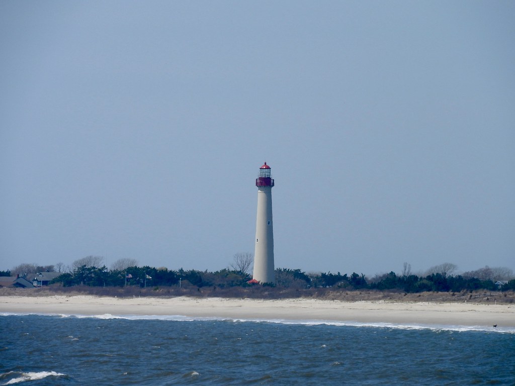
Another wonderful light appeared at the far southern tip of New Jersey. The Cape May Lighthouse began operations in 1859 and continues to serve as an active navigational aid today (map). Two predecessor lighthouses sat at unfortunate locations nearby. Actually, those sites no longer existed, having been swallowed by the sea.
The current structure fared much better though, placed a little farther back from the shoreline and constructed to withstand the strongest hurricanes. We saw more tourists here than at any of the other lights. It didn’t surprise me. We stopped by on a warm afternoon with perfect weather.
Bonus!
We even found a couple of unexpected lighthouses as we rode the ferry across the mouth of Delaware Bay. We couldn’t stop at either one them of course, although we did get close enough for some pictures.

No natural harbors existed near the entrance to Delaware Bay so a series of breakwaters were constructed in the vicinity of Lewes, Delaware during the second half of the nineteenth century. These collectively came to be known as the National Harbor of Refuge. Ships heading up or down the Atlantic coast or over to the port of Philadelphia that encountered stormy conditions could stop at the refuge for safety. Lighthouses were used as beacons to mark the breakwaters. The Harbor of Refuge light became a primary focal point.
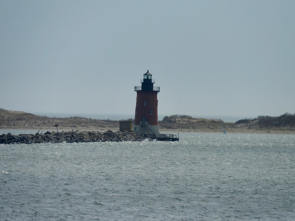
The Delaware Breakwater East End Light served in conjunction with the Harbor of Refuge Light to guide those ships to safety.
Articles in the Jersey Shore Series:
See Also: The Complete Photo Album on Flickr
Leave a Reply