
New Zealand anchored the southwestern end of the Ring of Fire, a long strand of seismic and volcanic activity on the outer edges of the Pacific Ocean. Here the earth’s tectonic plates collided, with results particularly apparent on the nation’s North Island. No active volcanoes currently threatened although cracks and fissures hissed angrily in numerous places. One such spot happened in and around the town of Rotorua in the north-central part of the island. We headed inland to Rotorua for a couple of days of geothermal exploration (map).
Lake Rotorua
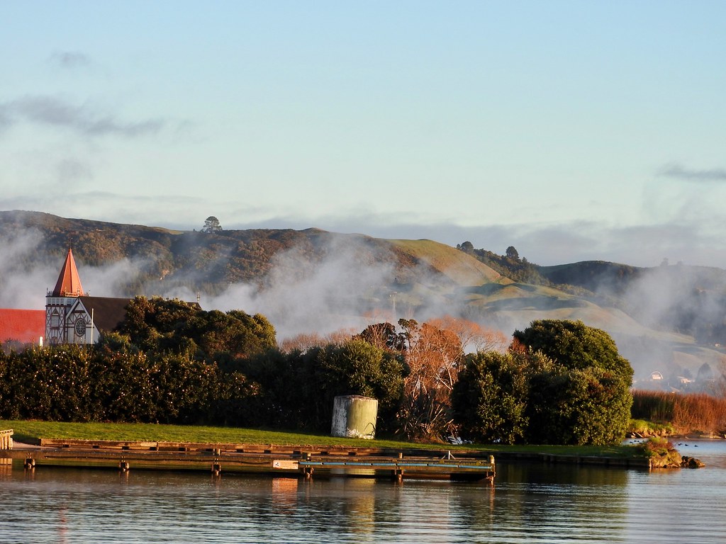
Rotorua hugged the shores of a lake with the same name, all part of the larger Rotorua Caldera. A large volcano erupted here about 250,000 years ago. This caused the surrounding land to collapse and fill with water over time. However, the volcano remained active and many millennia later, Maori people settled along the lake in a valley blanketed by steam. Europeans arrived in the Nineteenth Century and transformed Rotorua into a spa destination by the 1880’s. Neither group likely understood that they’d selected their home inside of an active volcano.
What looked like low-lying clouds in the photograph I captured along the banks of Lake Rotorua deceived the eye. This “fog” actually came from deep within the earth and escaped through fissures. A light odor permeated the town, consistently noticeable although not overpowering, the telltale rotten egg smell of sulfur. Some people found the smell unpleasant and jokingly considered that the “rot” in Rotorua. It didn’t bother me too much though.
Kuirau Park

An early morning walk through Rotorua seemed otherworldly. Steam hissed from cracks throughout the town forming a haziness across roadsides, in the middle of residents’ yards, and even up from random storm drains. A crisp winter chill only punctuated the effect. I took the opportunity to route my stroll through Kuirau Park (map). Here, I could experience geothermal activity more personally.
Paths and boardwalks crossed bubbling mudpots and boiling pools in an otherwise typical municipal park. The convenience couldn’t be beat, just a short stroll from city centre and a few blocks away from the house we rented. I’d see larger and more impressive geothermal sites later in the trip although Kuirau Park presented nice features at a bargain price. Anyone could walk through Kuirau for free. That made it a perfect introduction to this land of fire.
Wai-O-Tapu

Our older son and I drove down to Wai-O-Tapu about a half-hour south of Rotorua. It was just the two of us. My wife stayed behind with our younger son who somehow caught a nasty cold the first day he arrived in New Zealand and needed a rest day. The drive included us circling around the same roundabout a few times trying to catch the right exit. That was due to driver error not the signage. All those Maori place names confused me. Thankfully, I selected the right path eventually and the rest of the journey passed uneventfully (map).
This place dwarfed Kuirau Park in terms of size, presentation and variety of geothermal features. It took a couple of hours to complete the full set of trails through the park. Wai-O-Tapu included large boiling lakes, sulfur encrusted fissures, iridescent pools, mudpots galore, lush vegetation and even a boiling waterfall. I think I’d count Wai-O-Tapu as the best geothermal site of the trip, though not to diminish the impressiveness of others but to highlight the sheer natural wonder of that magical spot.
Te Puia

We then returned to Rotorua to see the Te Puia Centre for Maori Culture and Geothermal Wonders on the edge of town (map). This included many of the same things we’d seen at the other places with one big addition: a massive geyser. Te Puia fell within the Whakarewarewa Thermal Valley and several geysers could be seen there. The largest one, Pohutu Geyser, erupted several times a day. Our guide could predict when that might happen and she made sure we arrived just in time for a close-up view of the big event. Sure enough, steaming water shot 30 metres (100 feet) in a powerful jet for several minutes as we watched in awe.
That seemed like a perfect way to cap-off our full day amongst the volcanoes.
Articles in the Australasian Adventures Series:
- Preparations and Arrival
- On the Waterfront
- Vistas
- Geothermal
- Heading Inland
- The Hunter Region
- Wild Animal Encounters
- Captive Animal Encounters
- Epic Runs
- Breweries
- Lists
- Changes
See Also: The Complete Photo Album on Flickr
Leave a Reply