
The recent Prince George Exclave article explored Virginia’s unusual laws and how they created an unexpected result geographically. It didn’t end there. I reexamined the borders of each of the states’ independent cities for additional anomalies. The intersection between complicated annexation procedures and disparate city-county interests created some rather dysfunctional situations.
All base maps and boundaries came from the excellent Mob Rule website, and its “county lines imposed on Google maps” option. I added labels and arrows for clarity.
Colonial Heights Avoidance
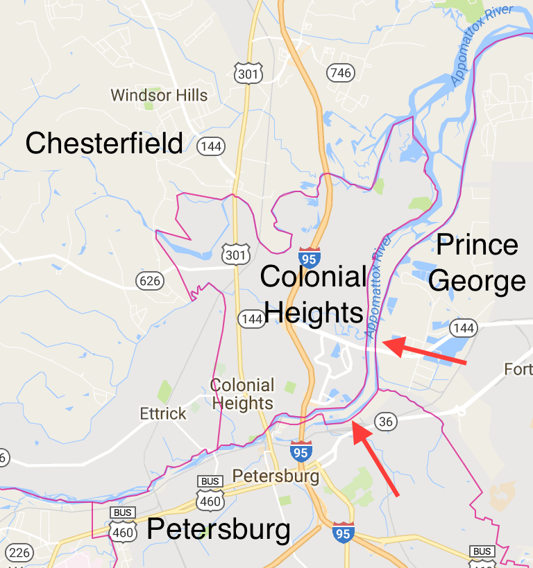
Presumably independent cities submitted annexation proposals because they wanted something attractive, like adjacent parcels with favorable businesses and residential density. Conversely, they would also want to avoid certain pieces of land. That seemed to be the case with the Prince George exclave where the City of Hopewell didn’t want to use its own tax receipts to maintain the Route 10 bridge. I think something similar may have happened when the city of Colonial Heights gained independence in 1961.
For whatever reason, Colonial Heights didn’t seem to want to deal with the Appomattox River. Maybe road and bridge maintenance figured into this, or maybe the city viewed owning a bunch of uninhabited river islands as inconvenient. Who knows. Regardless, Chesterfield County’s original border on the eastern side of the river remained in place. The judicial panel that granted this annexation approved Colonial Heights’ border on the western side of the river. That created a long, narrow tendril of Chesterfield wrapping around the eastern and southern flanks of Colonial Heights. It also prevented Colonial Heights from ever sharing a border with Prince George County, separated by only a tenth of a mile at one place along Route 144, Temple Avenue.
Also unbeknownst to me, I never knew that I’d driven through a tiny sliver of Chesterfield while traveling between Colonial Heights and Petersburg on Interstate 95. I’ve taken that route probably a hundred times over the years. Google Street View images revealed no highway signage for that anomaly. It’s no wonder I hadn’t figured it out until now.
James City Boundary Cross
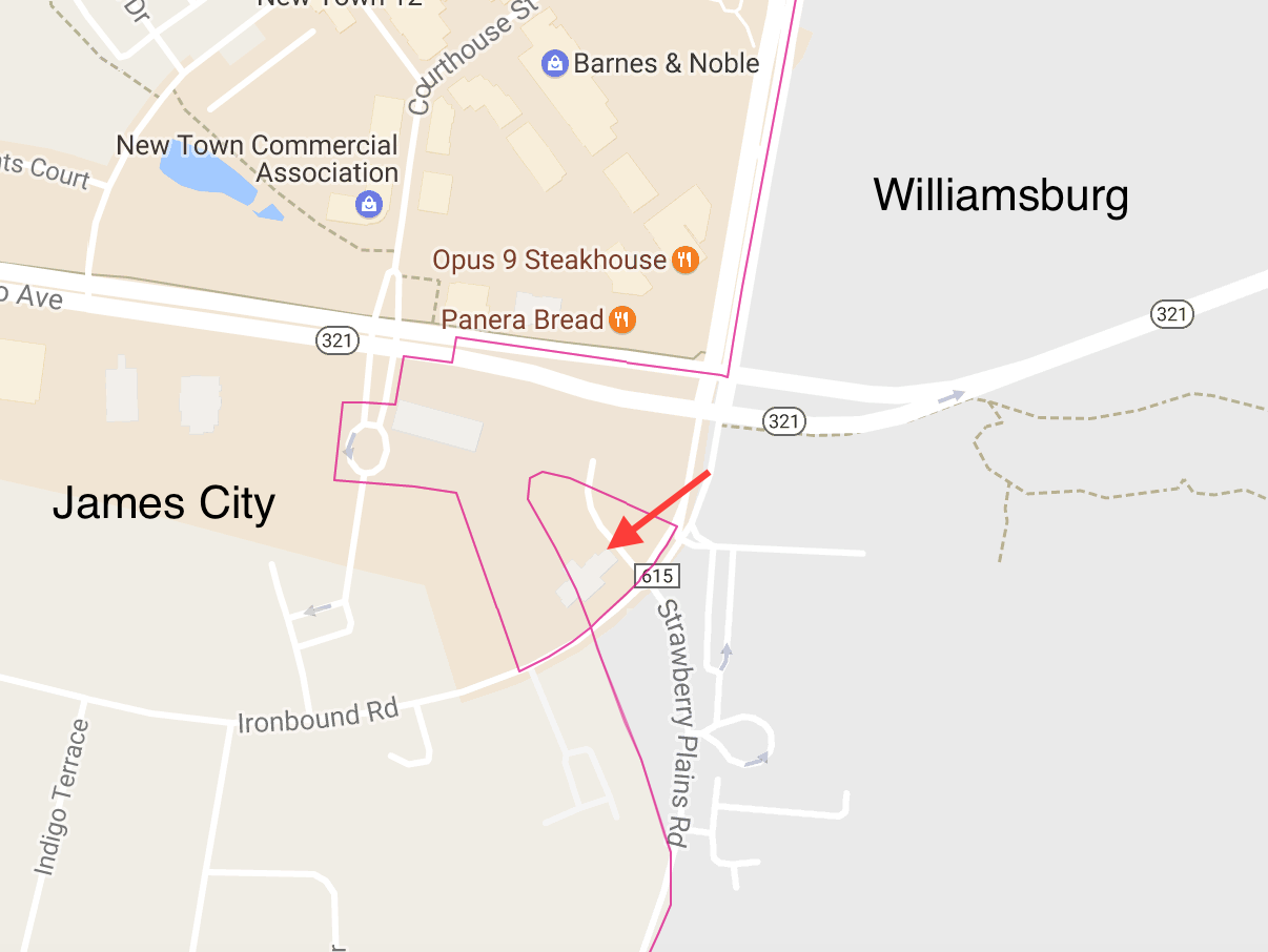
Quadripoints can be a lot fun. I certainly enjoyed my trip to the Four Corners marker in the southwestern United States a number of years ago. However there existed an even stranger version of this phenomenon, the elusive quadripoint boundary cross. These occur when a section of a territory — national, provincial, county, etc. — connects to its affiliated territory by only a single point. Twelve Mile Circle featured a trio of such international quadripoint boundary crosses in its earliest days (Jungholz, Baarle-Hertog, and the since-eliminated Cooch Behar situation).
However, I found it difficult to describe the phenomenon. Maybe the image above conveyed the situation better. Notice the border between James City County and the independent city of Williamsburg. A chunk of James City, almost completely surrounded by Williamsburg, connected to the remainder of James City only at the boundary cross.
Also the name bothered me. James City County sounded a bit schizophrenic. Did it want to be a city or a county? Make a choice, James. They might be forgiven though. The name went all the way back to the original colonial James City Shire established in 1634. Government officials simply carried its historical designation forward. Either way, it was definitely a county and not an independent city despite the name.
Nonetheless, there seemed to be no compelling reason for this nearly disconnected chunk of James City County. A parking lot and part of a medical center occupied most of its space (Street View). I had visions of city and county attorneys battling back-and-forth during the annexation hearing. Maybe this reflected the results of a heated negotiation. James City County managed to hold onto that little corner.
Bristol Boundary Cross
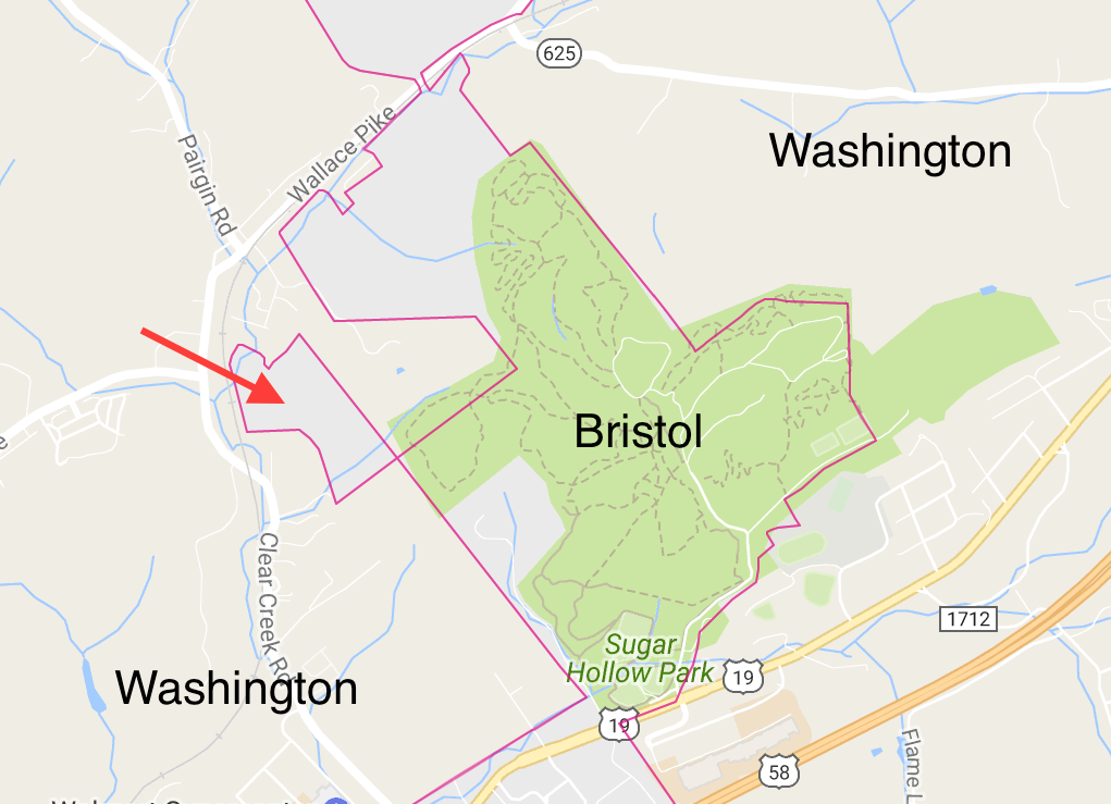
Additionally, a similar situation existed at the northern edge of the independent city of Bristol. Washington County surrounded Bristol everywhere except on the southern side where the state of North Carolina Tennessee bumped up against it. Bristol’s northern appendage seemed to be bolted-on to the remainder of the city, somewhat haphazardly. The initial nub contained public space, the Sugar Hollow Park. I supposed every city deserved a good park and this one featured camping, sports fields, picnic pavilions, bike trails and a pool. That was a logical annexation. Nicely done, Bristol.
The next nub farther up surrounded a reservoir built in 1965, Clear Creek Lake. A golf course hugged its eastern shore. Kudos again to Bristol for its strategic annexation, even if the space attached to the rest of the city by only a hundred-foot neck.
However, the Sugar Hollow Park nub also connected to an even smaller parcel of Bristol through a quadripoint boundary cross. This parcel accommodated a single house on several acres of forested land. I dug a little deeper and found its address: 13174 Topeka Drive. According to Zillow this 1939 home had 2 bedrooms, 1 bath, and 1,034 square feet of livable space. The estimated value was $89,101. Someday I’d love to know the sequence of events and special reasons that led to this single home becoming a part of Bristol. Did the mayor live there or something? It made no sense.
The independent city oddities continued although I got tired of typing. So, Part 2 will explore enclaves within the cities and pinches that came close to creating the same.
Leave a Reply