
Which two national capitals are located closest together? This is another one of those tricky trivia questions designed to fool people into overlooking the obvious. Doubtless they probably think about places where countries pack tightly together, maybe Western Europe maybe Central America, perhaps forgetting about all the tiny micro-nations because those tend to fade into the woodwork, and of course that’s the key to solving many of these little puzzles.
I’ve seen enough of these that I’ve conditioned myself to guess reflexively that either Vatican City or Alaska will somehow turn up among the answers depending on the context. My standard, unthinking answer to this question would be to focus on Vatican City since Alaska isn’t a nation (yet). Regular readers of the Twelve Mile Circle may take similar approaches because we’ve all encountered geo-trivia for ages. But we’re a special bunch. We’re all 180 degrees out-of-synch with the rest of the world and we take pride in our geo-geekiness.
Rome and Vatican City
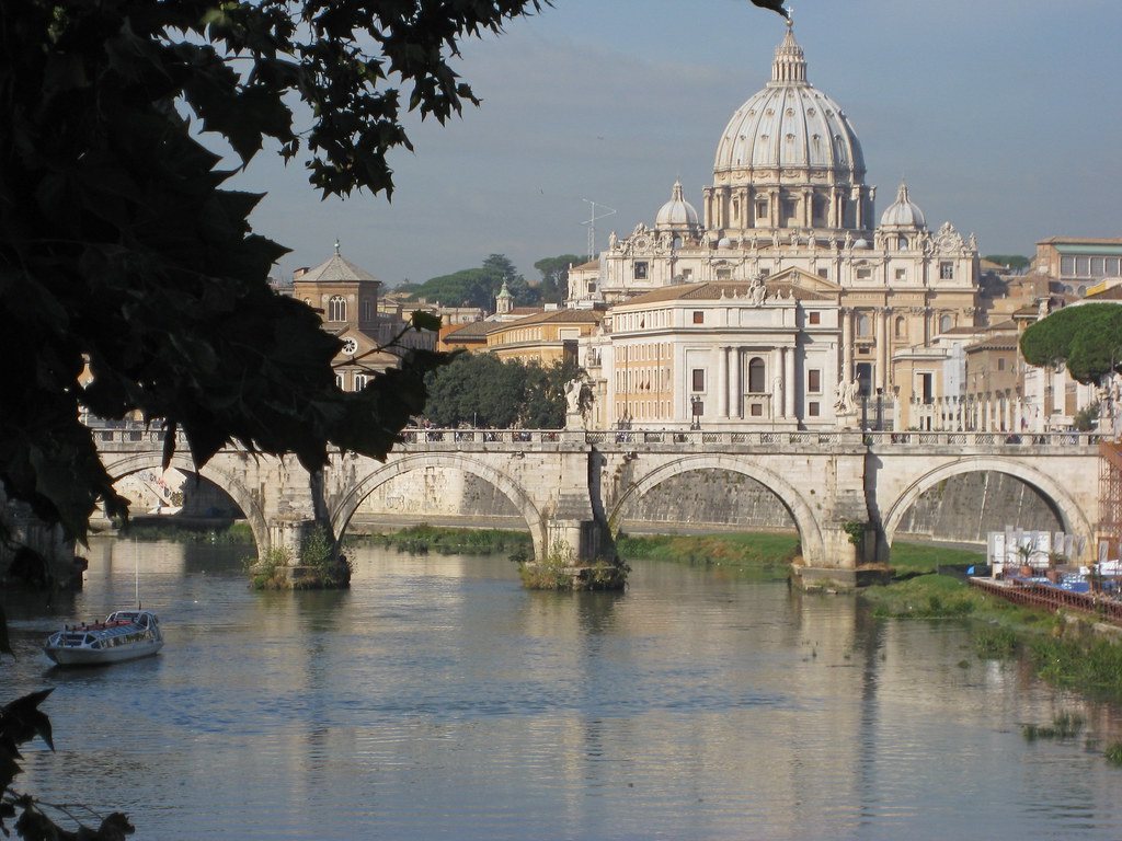
Indeed, the two national capitals closest together are Rome, Italy and Vatican City. Rome completely envelopes Vatican City. It’s hard to get any closer than that. Sure, some may quibble that Vatican City is really a sovereign city-state that doesn’t have a defined “capital” per se. It’s hard to argue against that from a purely technical perspective, however focusing on hairsplitting takes all the joy out of these silly questions. The answer for 99.95% of the population is that Rome and Vatican City are the two national capitals closest together.
OK, job done for today. Everyone can go home now.
Nothing is ever that simple on this blog
Honestly, the Rome-Vatican City answer doesn’t interest me at all. Another answer is much more interesting and much less obvious. So throw that earlier answer out the window and let’s ask the question again: Other than Rome and Vatican City, what two national capitals are located closest together?

Answer: Brazzaville, Republic of the Congo and Kinshasa, Democratic Republic of the Congo . To mitigate the name confusion recall that the Democratic Republic of the Congo used to be Zaire until recently. Others differentiate the nations by referring to them as Congo-Kinshasa and Congo-Brazzaville.
The two national capitals sit on opposite sides of the Congo River within clear site of each other. Thus, the physical distance between the two equals the width of the river. However, but back to splitting hairs, they probably share a common border somewhere in the middle of that river. So maybe we can consider that contiguous. It’s as good an answer as Rome-Vatican City in my book.
What surprised me, and I admit that this is a blindspot due to my western- and euro-centric upbringing, is the sheer enormity of this greater metropolitan area. This is a home to nine million people, an absolute megalopolis of epic size and yet the answer didn’t come leaping off the screen at me. That population is on the order of Chicago for the sake of comparison. I’ve got to become smarter on the geography of this area.
Additional Contenders
I also came up with some “also-rans” as I poured through maps in search of answers. Doubtless you came up with some too. I dropped a few of them into the Google Maps great circle distance calculator:
- Vienna, Austria and Bratislava, Slovakia (54 kilometers/34 miles/31,928 smoots)
- Jerusalem, Israel and Amman, Jordan (74km/46mi/43,438sm) – I do realize that listing Jerusalem as a capital city may be controversial in some quarters, and I’m not trying to make a geopolitical statement here. Just drawing some lines on a map.
- Helsinki, Finland and Tallinn, Estonia (78km/47mi/46,001sm) – across water.
- Damascus, Syria and Beirut, Lebanon (86km/53mi/50,547sm)
- Castries, Saint Lucia and Kingstown, Saint Vincent and the Grenadines (91 km/56 mi/53,286 sm) – between islands.
- Seoul, South Korea and Pyongyang, North Korea (195km/121mi/114,834sm) – this one is really scary.
I’m frequently impressed, quite pleasantly as a matter of fact, with the vast collective knowledge of the regular readers here, so please feel free to add to the list or make corrections.
One More Item of Interest
[Editor’s Note: the situation described below was true when the article was written in 2009. Now, however, the situation is completely different]
I notice one other interesting point as I was pondering this question and preparing this article. I put together this nice little map showing the capital cities mentioned in the Middle East: Damascus; Beirut, Amman and Jerusalem.
Notice anything unusual?
No roads display for Israel. The entire country is a big empty splotch devoid of any road network or identifying feature whatsoever. Given the political situation I could understand if this were the case for all Google Map images of Israel but it applies only to map images embedded on external websites. Thus, the information is readily available on Google but blocked elsewhere. Truly odd.
Leave a Reply