
I thought I’d written an article about Africa’s Lake Chad a long time ago. Naturally I was surprised to see it still listed on my potential topics spreadsheet when I culled it recently. A quick search of the 12MC WordPress database found minor references to Lake Chad and little else. So I guess I should address that oversight.
The basin feeding into the lake is endorheic. That means water falling here doesn’t have an outlet to the sea. Rather, liquid drains to the lowest point of elevation in the typical manner. In this this case it’s a depression in the earth caused by tectonic forces, resulting in the creation of Lake Chad.
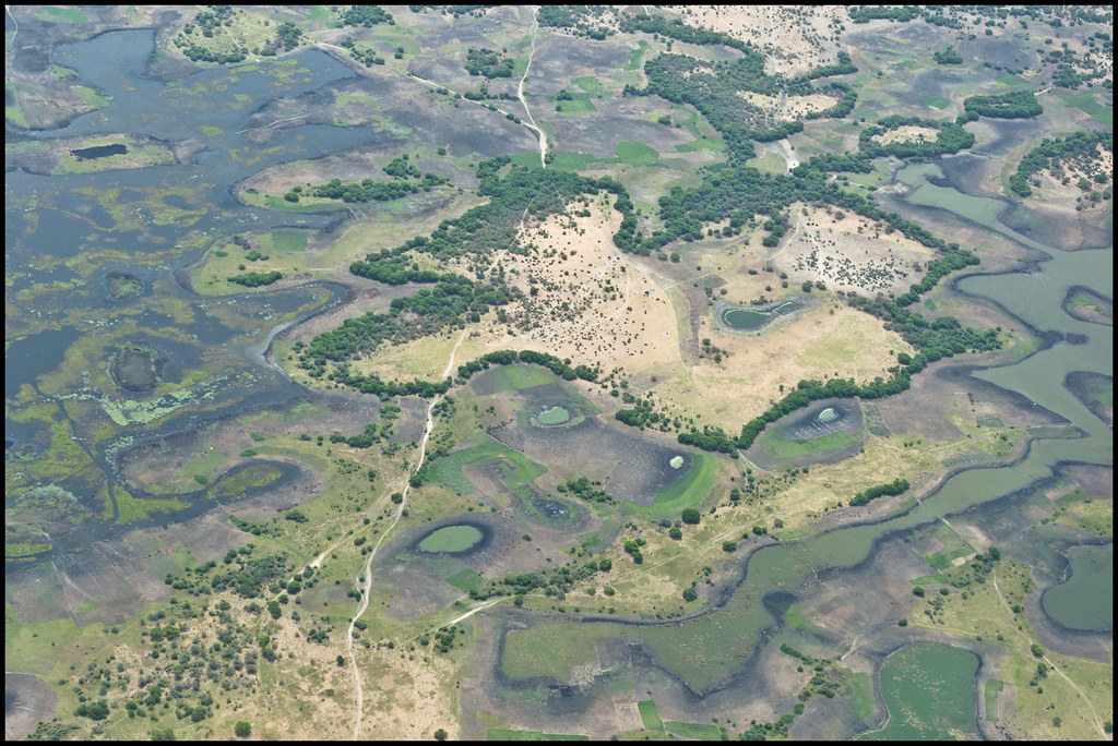
However, calling it a lake might be a bit misleading. The lake includes a mixture of smaller lakes and ponds and pools and marshes and mud. Lake Chad grows and contracts as rain falls or it doesn’t. It follows an annual cycle of wet and dry seasons, through times of abundance and times of drought. Also, this is a very shallow lake, only 10.5 metres (34 feet) at its deepest point. Thus, expansion or contraction can be quite dramatic even within a single year during the interplay between evaporation and replenishment.
The Lake is Dying
The Lake Chad Basin Commission proposed three Lake Chads. This represented a set of variations noted as small, medium and large Lake Chad.
“Lake Chad covers less than 10% of the area it occupied in 1960… The current Lake Chad is an ordinary ‘small Lake Chad’, as it has been several times in the past. It has hardly witnessed any major changes since the beginning of the Sahelian drought of 70 years, except for minor seasonal and interannual fluctuations which are typical of its normal functioning.”
Other sources sounded considerably less optimistic. The United Nations’ AfricaRenewal described it as “one of the most important agricultural heritage sites in the world, providing a lifeline to nearly 30 million people”. However, it noted “The UN Food and Agriculture Organization (FAO) has called the situation an ‘ecological catastrophe,’ predicting that the lake could disappear this century”. Whether natural cycle or permanent situation, this dwindling freshwater reservoir contributes to international tensions.
Drawing Lines
European colonial powers all wanted a piece of the lake. After all, it was an unusually large source of water near the southern rim of the Sahara Desert. Of course, colonial powers relinquished control eventually. They left behind four nations sharing the lake; Nigeria, Niger, Chad (or Tchad) and Cameroon. Also this created two different tripoints within the lake: a Nigeria, Niger, Chad tripoint; and a Chad, Cameroon, Nigeria tripoint. Two of the nations do not share a border. Niger and Cameroon are separated by about 85 kilometres (53 miles).
An Odd Appendage
I wondered about the unusual northern appendage of Cameroon that extended up to Lake Chad like a sipping straw. This traced back to European control too. It was an artifact of German possession of “Kamerun” for several decades prior to the First World War.
Meanwhile, the United Kingdom grabbed a corner of the lake in the formation of Nigeria. France behaved similarly with respect to Niger and Chad. Thus, three European powers near the turn of the Twentieth Century coveted these waters. They carved the land into colonies, and set the stage for its current international configuration.
That northern notch of Cameroon carried an appropriate name, the Région de l’Extrême-Nord. It meant Extreme North Region or Far North Region when converted into English (both are used). The northernmost department of this region was Logone-et-Chari. The department also had a northernmost settlement, Blangoua, along the Chari River. It fell near the point where it emptied into Lake Chad itself. That was the end of the road, as extremely north as one could settle in the extreme north of Cameroon. I found a YouTube video about this isolated Cameroonian outpost, or at least I think that’s what I found because it was in French. Regardless, the imagery provided a fascinating window on the people who lived along the lake.
Implications
Four nations sharing a valuable resource had to find a way to cooperate. This led to the creation of the Lake Chad Basin Commission:
“The mandate of the Commission is to sustainably and equitably manage the Lake Chad and other shared water resources of the Lake Chad Basin, to preserve the ecosystems of the Lake Chad Conventional Basin, to promote regional integration, peace and security across the Basin.”
Nonetheless peace and security have been at risk in the last several years because of the rise of Boko Haram in northern Nigeria. This included the Lake Chad border area. As noted by Cameroon Info.Net [link no longer works]
“Using porous borders with Chad, Niger and Cameroon in the desolate scrubland around Lake Chad, they are smuggling bigger weapons, staging cross-border raids, killing and kidnapping in an escalation of violence that could further draw Nigeria’s neighbours into its counter-insurgency fight, security officials say.”
Reuters reported that Cameroon was sending 700 soldiers into the Extreme North in March 2014. This would be “as part of a regional force to tackle armed groups in an area where Nigerian Islamist militant group Boko Haram operates.”
The future looked pretty scary in the Lake Chad region.
Leave a Reply