
The visit to the Alaska’s Kenai Peninsula is winding down. Unfortunately I will be making my way back home over the next couple of days. Those of you who follow Twelve Mile Circle for its odd geography can rejoice. I’ll return to a regular schedule of useless trivia that only we enjoy. Well, unless something totally unusual happens over the coming hours. Those of you who enjoy the travelogues, well, there’s always the next trip.
Crazy Tides

I know someone asked me about the amazing tides in coastal Alaska. I seem to have misplaced the message so please accept my apologies, anonymous reader whoever you may be, for the outstanding tip. It made for an interesting visit to Captain Cook State Recreation Area. That’s also as far northwest as one can travel on the Kenai Peninsula using paved roads. The City of Anchorage is just up the inlet from here where Turnagain Arm splits away. Someone standing here in 1778 would have seen Captain James Cook sailing past on his third expedition as he searched for the famed Northwest Passage. Now it’s known as Cook Inlet.
I took this photograph at nearly low tide. Notice that the tidal area extends nearly to the outer edge of the image. This entire muddy flat filled with water only a few hours later. According to the National Oceanic and Atmospheric Administration: “The highest tides in the world can be found in Canada at the Bay of Fundy, which separates New Brunswick from Nova Scotia… Anchorage, Alaska, comes in at a close second with tidal ranges up to 12.2 meters (40 feet).”
I’ll have to content myself with “second best” which is still rather impressive.
Westernmost Highway. Maybe.

A town has to stake its fame on anything imaginable in these rural lands. It’s all about differentiation. Everyone seems to be searching for that magic hook that might bring a few more tourist dollars during tough economic times. I get a sense that tourism is way down here. It’s the height of summer, the salmon are running, and vacancies still abound. Yes, Anchor Point plays the game too. They bill themselves as the westernmost point of the United States and/or North American highway system (map).
Well, it might be true.
I guess it depends on how one defines “highway.” Does the Alaska Marine Highway, an extensive system of ferries extending all the way to the Aleutian Islands count? If so, extend that westernmost claim to Unalaska/Dutch Harbor. If the claim requires pavement I guess Anchor Point is a good as any other claimant. Well, at least until Alaska builds a long-planned route to Nome.
I saw a number of photos on the Intertubes of a marker that commemorates the spot in Anchor Point. I couldn’t find that marker anywhere. However, I also didn’t look very hard as I drove through town, passing in the blink of an eye. Nonetheless if one wants to see the actual spot, it’s really a couple of miles north of town. I created a waypoint on my GPS prior to the journey. Then I took my photo when I hit the appropriate point while driving along.
Homer Spit

The Homer Spit provides another prominent geographic feature. “Homer Spit” sounds like something out of the Simpsons. Actually it’s a sandbar jutting more than four miles into Kachemak Bay. Wikipedia claims that “the Spit features the longest road into ocean waters in the entire world, taking up to 10–15 minutes to cover by car”. I don’t know if it’s actually true. Nonetheless I’ll concede that it’s definitely an odd site to be set below the otherwise hilly terrain.
It seemed out of place for other reasons too. The large concentration of beach shacks hawking t-shirts, beachwear, alcohol, sugary snacks and such seemed more reminiscent of the familiar boardwalk scene down in the Lower 48 than the wilds of Alaska. There was even an entire shop devoted to selling every item that could be imprinted with the logo of the Time Bandit, one of the ships featured on the Deadliest Catch television reality show. Apparently, Time Bandit uses Homer as its home port. Well, I certainly can’t fault the captain for trying to make a few bucks during his 15 minutes. It’s a lot easier than pulling crabs during harsh winter storms.
If someone stuck a Ferris Wheel at the tip of the spit it would become a miniature version of Santa Monica or maybe coastal New Jersey. It didn’t seem like Alaska to me. So I didn’t spent a lot of time there despite my fascination with the extended sandbar as a geographic oddity.
Mile Zero
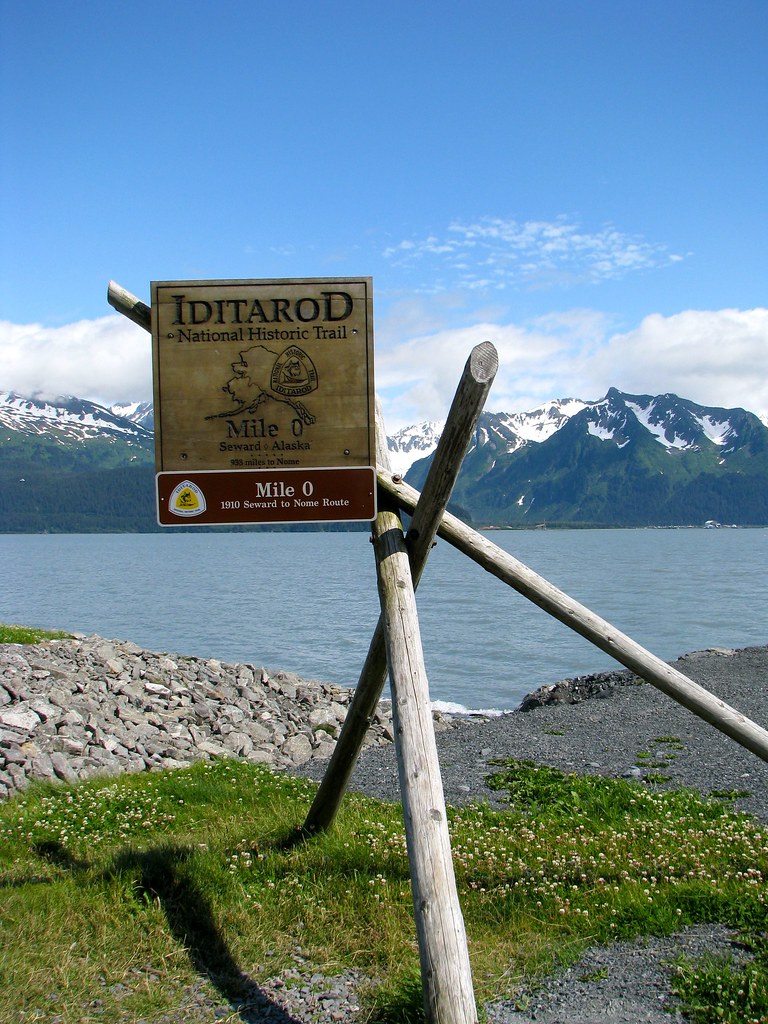
The Iditarod is more than an annual dogsled race. It’s also more than the heroic delivery of Diphtheria serum to Nome in 1925, the event commemorated by the modern Iditarod. The Iditarod is actually an historic trail used to transport goods into the remote Alaskan interior. Seward is one of the northernmost ice free ports in North America and is a natural starting point for supply routes. Mile Zero of the Iditarod, the 1910 Seward to Nome Route, began here and extended for 938 miles to Nome. It didn’t last long. Airplanes replaced it within a couple of decades.
But did it really begin here? Well, it actually started about fifty miles north. The railroad did began in Seward and the trailhead extended from there. See what I mean about grabbing any hook?
Leave a Reply