
A previous article in this series noted the abundance of farmland with little else to be seen during my Heartland excursion. That didn’t provide a completely accurate picture. Variations appeared in unexpected ways although I needed to travel to the margins to find them. We charted our course purposefully. It allowed us to experience a few geological features that maybe didn’t fit cleanly into notional images of the American Midwest. Not everything out there fell within endless fields to the horizon.
Lots of Farmland, Of Course

Even the endless farmland offered scenic beauty although its prevalence sometimes made me wish for something else. I began to take it for granted. At some point towards the end of the trip I realized I hadn’t done much to capture its simple elegance. Then I had trouble finding a good subject. Suddenly this barn appeared along a quiet rural byway. It embodied what I’d been sensing all along in thousands of different places throughout the journey.
The architecture seemed peculiar to eastern Iowa where I spotted it, and to adjoining western Illinois. The barn itself appeared fairly standard. However I couldn’t recall seeing a similar cupola — or whatever one might call it — quite like it in other parts of the country. I guessed it helped lift hay bales into the loft.
The Beach

Our journey reminded me once again of the magnificent sand dunes on the eastern and southern flanks of Lake Michigan. I recounted the geology last summer when I explored outside of Grand Rapids. Essentially, glaciers melting at the end of the last Ice Age left a lot of debris behind. Winds and waves pushed glacial drift eastward, forming those wonderful sandy beaches of Indiana and Michigan.
Back home, I would never try to drive to the beach on Memorial Day weekend even though the Atlantic Ocean beckoned only a couple of hours away. I’d pick a more obscure day to miss the crowds and traffic. Somehow, even though I should have known better, I failed to grasp that Lake Michigan served a similar purpose for ten million people living in the Chicago metropolitan area. The lake, with its massive size, looked a lot like an ocean with smaller waves and fresh water. Throw in sand dunes and pristine beaches, and it completed the illusion. Feel free to insert sarcastic remarks about Easterners and their ignorance of places beyond their noses if you like.
Thank goodness for Waze. It took us around the worst of the traffic heading into Michigan City, Indiana and saved us at least an hour. I still carried my trusty paper map as a backup although technology certainly saved the day this time. It allowed us to visit the beach at Washington Park (map).
Lighthouses
Actually, I targeted Michigan City for its lighthouses. The combination of Indiana and lighthouses seemed odd, and yet a few lighthouses actually existed along its Lake Michigan shoreline. I collect lighthouse visits, another one of those things I counted compulsively, so it led us in that direction. Michigan City included two lighthouses, one a museum and one a functioning navigational aid. The beach was just a nice bonus.
Michigan City Lighthouse
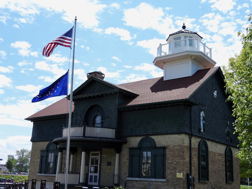
A land speculator wanted to create Indiana’s first harbor in the 1830’s. So he purchased a site where Trail Creek fed into the lake and he platted a town there. A proper harbor needed a lighthouse to guide ships into its port so he set aside room for that too. The first one didn’t work out as planned and another one came along in 1858 (map) and it came to be known as the Michigan City Lighthouse.
“As shipping in Michigan City increased, primarily grain and lumber, a brighter light was needed to guide ships into the busy port. In 1858, the U.S. Government constructed a lighthouse using Joliet stone for the foundation and Milwaukee or ‘Cream City’ bricks for the superstructure.”
That’s the one in the photograph, above, the current home of the Michigan City Historical Society’s Old Lighthouse Museum.
East Pierhead Lighthouse

Then came the East Pierhead Lighthouse (map), also known as the Michigan City Breakwater lighthouse, built in 1904. The lens and lantern moved from the old lighthouse to the new one at that time, too. Lighthouse keepers continued to live in the earlier structure while tending the light at the end of the pier. Sometimes ferocious storms pummeled the lake. Imagine what it must have been like trying to scoot along that narrow catwalk from shore to tower as icy waves crashed across the pier. We visited on a day with a light chop and even then a little water pushed onto the concrete.
Canyons
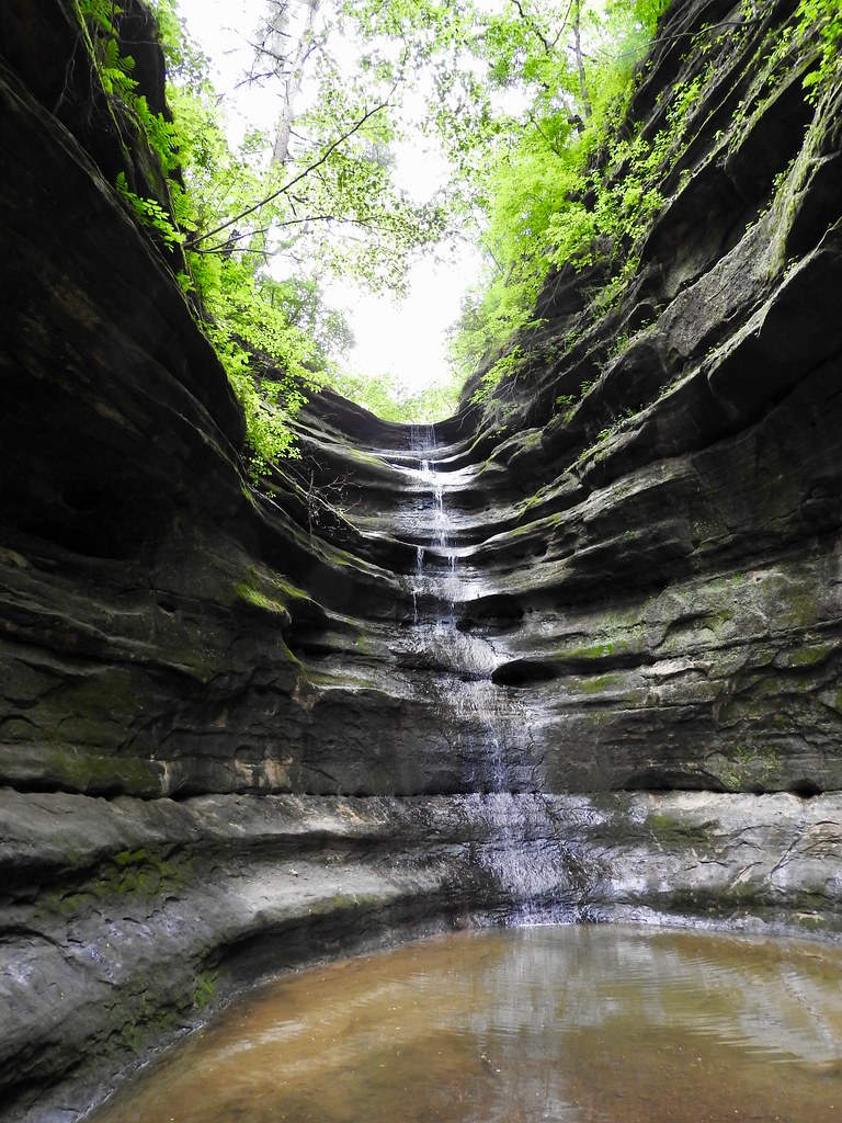
Canyons seemed unlikely as we drove across the flatness of central Illinois. Yet, Starved Rock State Park included them with abundance. Many features resulted from a cataclysmic event and an unusual geology.
The Illinois River ran along the park’s northern edge. A great flood tore through there sometime around 15,000 years ago, an event called the Kankakee Torrent. Melting glaciers formed a lake and it burst, scouring limestone along the riverbank. It carved huge bluffs in a matter of days. Wonderful scenic vistas crowned those same bluffs today (photo).
The park got its name from one of those bluffs. The explanation tied back to a legend, probably untrue although the story persisted. Supposedly, in some sort of dispute, a tribe of Native Americans besieged members of the Illini tribe who then sought refuge on a bluff. Surrounded, and unwilling to surrender, they died of starvation. The place became Starved Rock.
The park also contained several canyons behind the bluffs. Small streams carved into the limestone in wonderful terraces accompanied by waterfalls. French Canyon, named for the early European explorers of this area, became its most iconic feature (map). That’s the one in the photograph, above. Lots of people traveled to the park just to see that one attraction. It wasn’t much more than an hour away from Chicago, making Starved Rock the most visited state park in Illinois. Two million visitors come here every year.
Mighty Rivers

Of course I couldn’t fail to mention the Mississippi River… and the Illinois River was pretty impressive too. I’ve visited the Mississippi several different times in recent years including just a little farther downstream in April. I won’t bother to elaborate on its power again although I’ll note that I’ve always enjoy gazing upon it. Two of our races happened along the river on opposite banks. On one day the course went along a levee in Fulton, Illinois and the next day it did the same in Clinton, Iowa. I took this photo from the Illinois side (map).
Articles in the Heartland Series
See Also: The Complete Photo Album on Flickr
Leave a Reply