
Twelve Mile Circle receives a fair amount of reader mail and suggestions. Usually it leads to pleasant surprises and sometimes even an article. That happened recently with a map generated by Steve Spivey who graciously granted permission for me to share it with the 12MC audience.
Steve had been combing through the very earliest days of the site and came across Remote Southwestern Virginia, an article first published in November 2007. It demonstrated that Lee County in Virginia, the southwesternmost corner of the state, was closer to eight state capital cities (and possibly nine depending on measurement) than it was to its own state capital of Richmond. This also fascinated me at the time and spawned the Worst State Capital Location along with various other capital-related articles.
Voronoi Diagram
However Steve took a completely different angle by creating a Voronoi diagram(¹) with each state capitol building serving as a generating point. What if we reshuffled states based upon the closest existing state capital? Forget about geographical barriers, history, culture, politics and maybe hundreds of other practical considerations by reducing the problem to a purely mathematical process.
As an example, the 12MC headquarters is based in Arlington, Virginia. It’s 106 miles (170 km) from Richmond and only 39 miles (63 km) from Maryland’s capital in Annapolis. Mathematically a reconstituted Maryland might be a better state for me if distance was the only consideration and nothing else mattered.
Let’s take a look at the resulting Voronoi diagram, and of course feel free to open the image in another tab to experience the effect in full-sized glory.
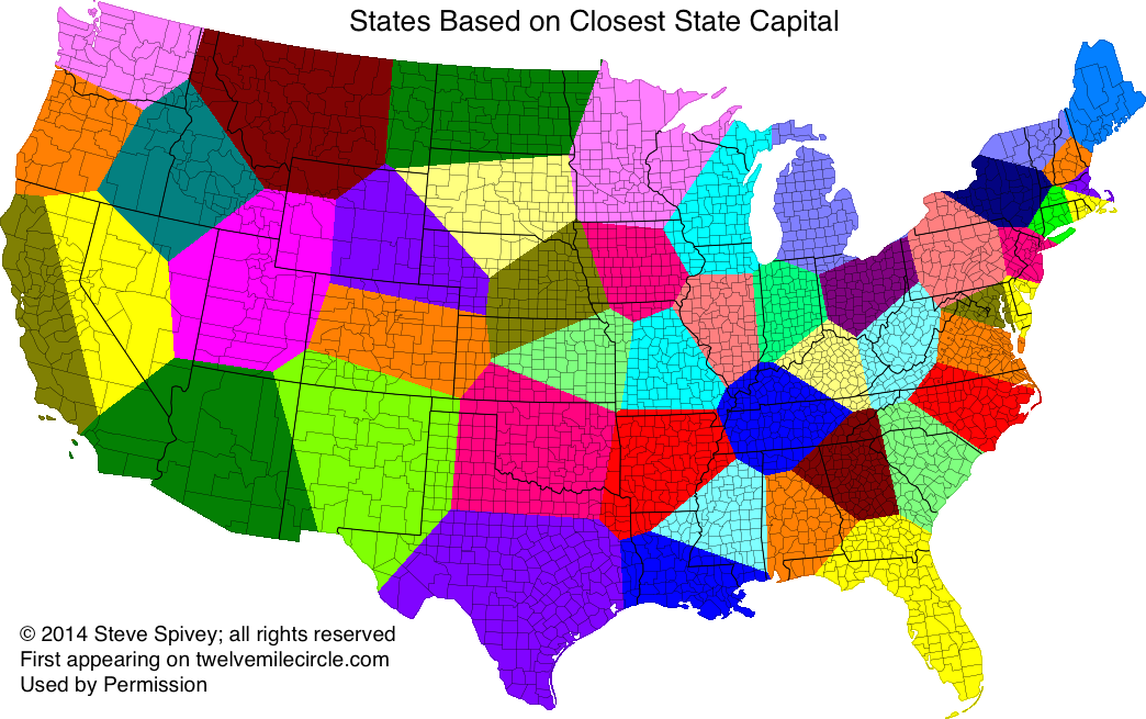
Reshuffling
Some states would become winners, other losers and some like Maine and Washington would remain largely unchanged. Alaska and Hawaii would stay the same because of their remoteness so I excluded them. Chicago would join Wisconsin, New York City would move into New Jersey, and the Los Angeles metropolitan area would split between California and Arizona. Parts of Texas would split into four neighboring states.
The smallest states, Rhode Island and Delaware, would become major beneficiaries. They would retain their existing geographic integrity while picking-up surrounding territory. Rhode Island and Connecticut would encroach on Massachusetts to such an extreme that Massachusetts would transform into the new Rhode Island (i.e., the new smallest state). Virginia would diminish considerably although why would I care? I’d live in Maryland. Meanwhile, neighboring West Virginia would grow to become the unquestionable king of Appalachia.
Many of the states farther west would continue as territorial behemoths although their familiar shapes might soften or erode entirely. North Dakota would maintain it familiar rectangle although larger. Idaho, on the other hand, would transform into an unrecognizable diamond.
Anyway it was a fun diversion although otherwise kind-of meaningless. That made it a perfect balance of intellectual silliness that sent me along a mental tangent for awhile. I loved examining the map, each time finding something different as I imagined the new world order.
Another Consideration
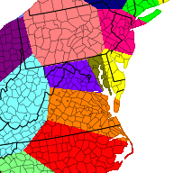
Steve took the game one step farther. What if we considered the District of Columbia as a state-equivalent and included it within the calculation? That of course would require us to set aside even more practical considerations including an obvious Constitutional question(²) although none of those mattered for this exercise. It would impact only the Mid-Atlantic region as pictured above. My residence would become part of the new, larger Washington, DC, while Maryland would reduce to a narrow strip hugging the rim of the northern Chesapeake Bay anchored by Baltimore.
Steve was thinking about producing similar maps for Canadian provinces as well as a worldwide version. We should encourage him in those pursuits. Thanks Steve!
12MC Loves Footnotes!
(¹) A Voronoi Diagram is “The partitioning of a plane with n points into convex polygons such that each polygon contains exactly one generating point and every point in a given polygon is closer to its generating point than to any other. A Voronoi diagram is sometimes also known as a Dirichlet tessellation. The cells are called Dirichlet regions, Thiessen polytopes, or Voronoi polygons.“
(²) Article I Section 8 of the U.S. Constitution specifies that the District shall “not exceed ten Miles square. So we’d need to amend the Constitution. No problem.
Leave a Reply