
Kilmartin Glen, Argyll, Scotland (January 2000)
There are few places in Scotland with such an incredible collection of archaeological sites as Kilmartin Glen. There are hundreds of monuments, fortresses, cairns, standing stones and carvings between Lochgilphead and Kilmartin (map). They range from the prehistoric all the way to the early days of the original Scottish kings. We discovered that we could easily reach most of these sites by driving up from the southern edge of the valley.
Duns, or forts, are some of the more remarkable sights along the roadside because of their grand dimensions. Archeologists have excavated some of them over the years. However many still remain untouched, and there may be at least a hundred in Argyll alone.
It was within Kilmartin Glen where the Dál Riata based their kingdom of Alba. As context, this became the precursor and foundation of modern Scotland. We gained an increasing awareness and appreciation of the archaeological and historical significance of this area as we absorbed each new artifact along the trail.
Dál Riata
The Dál Riata — sometimes known as the Dalriada or Dalriata — were a Gaelic people who probably came to Argyll from Ireland by 500 AD. Here they formed a kingdom spanning from northern Ireland and across open water to western Scotland. Kilmartin Glen became their principal base of power, centered on a high hillside crowned by their fortress Dunadd (map).
A dun is simply another name for a fort. This one happened to be located along the river Add, just a few miles from the sea. Logically the name became Dunadd (not Dunaad or Dunnad or other common misspellings).
They ruled their territory for a couple of centuries. Then their power faded and they fell under the control of Northumbria and the Picts. Nonetheless the Dál Riata became the first people known as Scots. They served as the progenitors of the Gaelic culture that characterizes Scotland today. So that counted for something pretty remarkable.
Strategic Placement
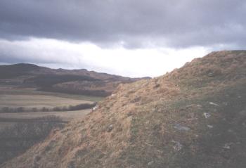
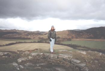
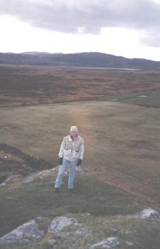
Dunadd rested atop the natural stone outcropping shown in this series of photographs. It sat well above the surrounding boggy plains in an easily defensible position. Thus they could spot approaching enemies miles before they arrived at Dunadd, providing plenty of warning to inhabitants. Upon arrival, aggressors would then have to push their way up steep terrain. Then they would have to overwhelm the stone walls of Dunadd itself. Unfortunately, little of the fort remained today. We saw a few earthworks and stones that may have once formed part of the floor and walls.
Also, in this part of Scotland, ancient historical sites coexisted routinely with the modern world. At Dunadd, the car park sat directly next to a private residence. So visitors had to take a trail practically through someone’s back yard to get to the site.
A Royal Domain
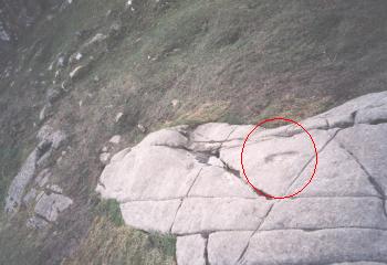
A stone shelf high atop Dunadd once served as part of the fortress floor. It contained a carving in the approximate shape and depth of a human foot which may have been used in a corronation ceremony for Dál Riata royalty. Rulers signified their physical connection to their surrounding domain by placing a foot within the carved rock. We placed our feet in the depression but it did nothing to raise us to royal status. Too bad. Even though we remained peasants, we enjoy the amazing views and solitude high atop Dunadd. Nobody else visited during the entire time of our hilltop expedition on this glorious winter afternoon.
Leave a Reply