
There are 33 Counties in New Mexico – “Land of Enchantment“
Also be sure to see my United States County Counting Page for the rest of the states.
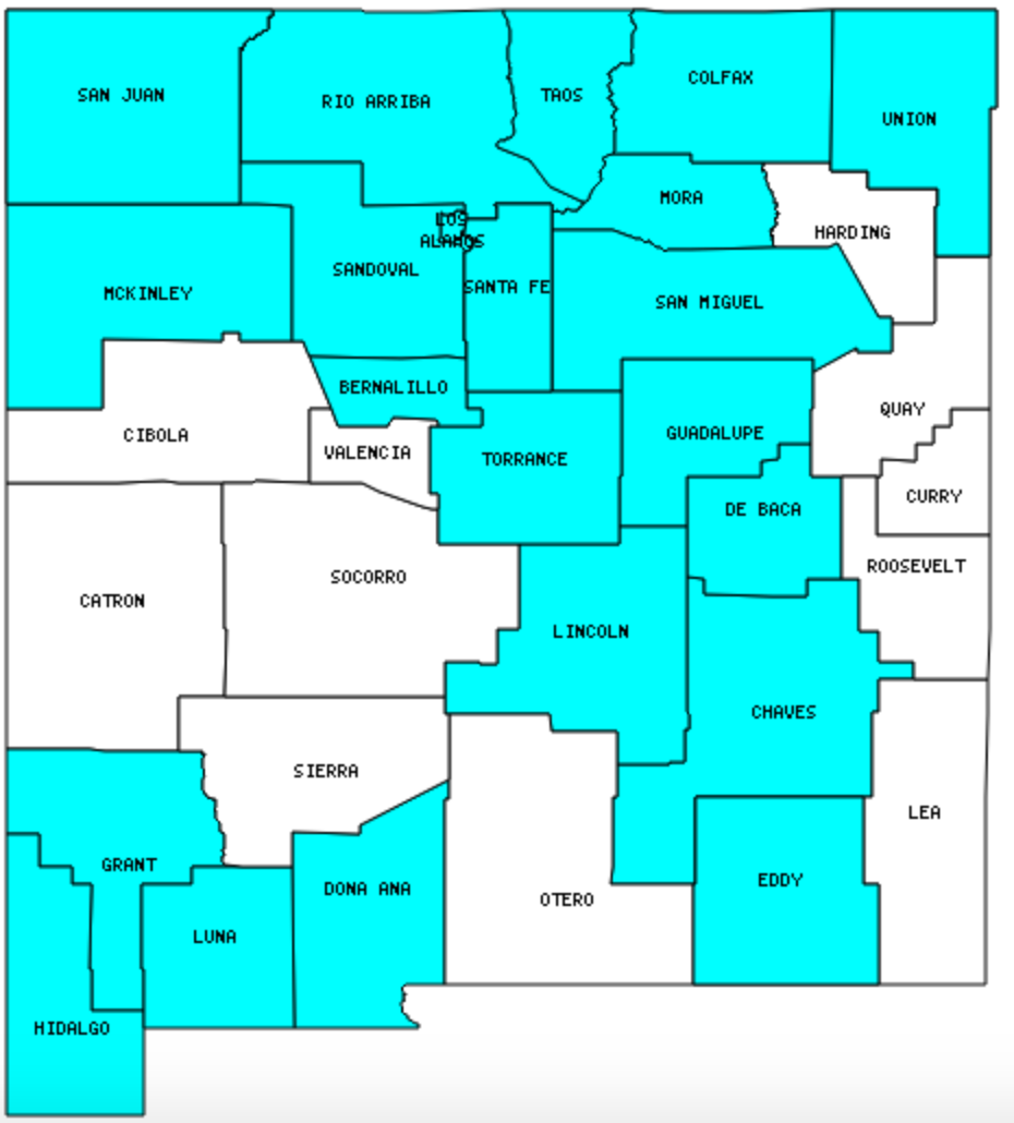
I have visited 22 Counties = 66.7% of Counties in New Mexico
Counties visited are colored-in; counties still needing to be visited are blank. Map created using Mob Rule.
Twelve Mile Circle Articles Featuring Places in New Mexico
Markers designate the New Mexico locations featured in Twelve Mile Circle articles.
Interesting New Mexico county trivia
San Juan County is New Mexico’s contribution to the Four Corners phenomenon, the only place where four states come together at a single point.
Counties in New Mexico

Below are the 67 counties in New Mexico. Although infrequent, counties sometimes do change so please let me know if any of this information is out of date and I will update it. Those counties that I have visited are highlighted in Red. Readers can also link to any articles manually in this section if the map isn’t working.
- Bernalillo: Largest county population in New Mexico (556,678 people in 2000 Census); Assets Grille & Brewing Company; Looney Tunes Geography; Pre-Nazi Swastikas; Pueblo Deco
- Catron: Largest county in New Mexico (6,928 square miles); Bat Cave Well
- Chaves
- Cibola
- Colfax: Comanche Creek Brewing; Agua Fria Peak
- Curry
- Debaca
- Doña Ana: Officially Tilde; Radioactive; Leap Year Capital of the World; Bordersplit; Fountain Theater
- Eddy: Carlsbad Caverns National Park
- Grant: Sensing Senses
- Guadalupe
- Harding: Smallest county population in New Mexico (810 people in 2000 Census); Last Presidential Counties
- Hidalgo: Brought Home from the Mexican War
- Lea
- Lincoln: Roswell Crash Site
- Los Alamos: Smallest county in New Mexico (109 square miles); Bathtub Row; The Sandoval Exclave (extends into Los Alamos County)
- Luna: Vulnerable to Invasion
- McKinley: Devil’s Highway
- Mora
- Otero: Comparison Nicknames
- Quay
- Rio Arriba
- Roosevelt
- San Juan: Pueblo Alto Trail; Four Corners Reflections; Chaco Culture National Historical Park; Adjacent Counties, Same Name, Different States; Four Corners – USA; Footloose; Gray vs. Grey; Loneliest Road in the USA
- San Miguel: Pecos National Historical Park
- Sandoval: Bandelier National Monument; The Sandoval Exclave
- Santa Fe: Tsankawi Trail; The Plaza; Not the Usual Capitol Building
- Sierra: Truth or Consequences
- Socorro
- Taos: Taos Pueblo; Greater World Earthship Community; Rio Grande Gorge Bridge
- Torrance
- Union: Capulin Volcano; Dinosaur Tracks; Thelma and Louise Spot; NM-OK-TX Tripoint; Mainly Marathons
- Valencia
Quick Facts About New Mexico
- Location: Mountain West United States. See map above.
- Size(1): 121,298 square miles. New Mexico is the 5th largest state. The next larger state is Montana and the next smaller state is Arizona.
- Population(2): 2,095,428 people. New Mexico is the 36th most populous state. The next more populous state is Kansas and the next less populous state is Nebraska.
- Population Density: 17.3 people per square mile. New Mexico is the 45th most densely populated state. The next more densely populated state is Idaho and the next less densely populated state is South Dakota.
- Bordering States: New Mexico shares a border with 5 states: Colorado; Utah; Arizona; Texas and Oklahoma.
- Admission to the Union: January 6, 1912. New Mexico was the 47th state admitted to the Union, after Oklahoma and before Arizona.
- Capital: Santa Fe.
- Highest Point: 13,161 feet at Wheeler Peak. See SummitPost’s Wheeler Peak page.
- Lowest Point: 2,842 feet at the Red Bluff Reservation in Eddy County.
- Government website: State of New Mexico.
- Official Tourism website: New Mexico Land of Enchantment.
- Still not enough? See Wikipedia’s New Mexico
Sources:
(1) Wikipedia: List of U.S. states and territories by area. Land area only.
(2) Wikipedia: List of states and territories of the United States by population. Estimated population on July 1, 2019.
Leave a Reply