
There are 99 Counties in Iowa – “The Hawkeye State“
Also be sure to see my United States County Counting Page for the rest of the states.
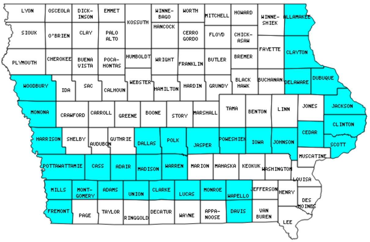
I have visited 32 Counties = 32.3% of Counties in Iowa
Counties visited are colored-in; counties still needing to be visited are blank. Map created using Mob Rule.
Twelve Mile Circle Articles Featuring Places in Iowa
Markers designate the Iowa locations featured in Twelve Mile Circle articles.
Counties in Iowa
Below are the 99 counties in Iowa. Although infrequent, counties sometimes do change so please let me know if any of this information is out of date and I will update it. Those counties that I have visited are highlighted in Red. Readers can also link to any articles manually in this section if the map isn’t working.
- Adair
- Adams: Smallest county population in Iowa (4,482 people in 2000 Census).
- Allamakee: Effigy Mounds National Monument; Quad County Towns
- Appanoose: Center of Power
- Audubon: For the Birds
- Benton: What State U
- Black Hawk
- Boone: Boone Scraps
- Bremer
- Buchanan
- Buena Vista
- Butler
- Calhoun
- Carroll
- Cass
- Cedar
- Cerro Gordo
- Cherokee
- Chickasaw
- Clarke
- Clay
- Clayton: Cassville Ferry; Old Man River Restaurant & Brewery; Quad County Towns
- Clinton: Clinton
- Crawford
- Dallas: X Marks the Spot
- Davis
- Decatur
- Delaware
- Des Moines
- Dickinson: Smallest county in Iowa (381 square miles).
- Dubuque: All In a Name
- Emmet
- Fayette
- Floyd
- Franklin
- Fremont
- Greene
- Grundy
- Guthrie
- Hamilton
- Hancock
- Hardin
- Harrison: Loess
- Henry
- Howard
- Humboldt: Throw the Dart
- Ida
- Iowa: Iowa-Iowa-Iowa
- Jackson
- Jasper
- Jefferson
- Johnson
- Jones: More Than Just a State
- Keokuk
- Kossuth: Largest county in Iowa (973 square miles); The Odd Case of Iowa’s Largest County; Can’t Get Enough of Kossuth
- Lee
- Linn: Potomac in Iowa; Résumé Bait and Switch; Nearly Nothing Named for Nixon
- Louisa
- Lucas: Last Chance
- Lyon
- Madison
- Mahaska
- Marion
- Marshall
- Mills
- Mitchell
- Monona
- Monroe
- Montgomery
- Muscatine
- O’Brien
- Osceola
- Page
- Palo Alto
- Plymouth
- Pocahontas
- Polk: Largest county population in Iowa (374,601 people in 2000 Census); Court Avenue Brewing Co.; Saint’s Brewing Company; Geo-BrEWities
- Pottawattamie: Carter Lake; Impressive Pedestrian Bridges
- Poweshiek
- Ringgold
- Sac
- Scott: Buffalo Bill Homestead; American Pickers; Great Scott
- Shelby: King of Portmanteau
- Sioux
- Story
- Tama
- Taylor: Natural Forces: Gravitation
- Union: Twelve Mile Mormons
- Van Buren
- Wapello
- Warren
- Washington
- Wayne
- Webster
- Winnebago
- Winneshiek
- Woodbury: Three Letter Oddities
- Worth: Directional Surname Frequency; Even More Manly Places
- Wright
Quick Facts About Iowa
- Location: West North Central United States. See map above.
- Size(1): 55,857 square miles. Iowa is the 23rd largest state. The next larger state is Michigan and the next smaller state is Illinois.
- Population(2): 3,156,145 people. Iowa is the 31st most populous state. The next more populous state is Utah and the next less populous state is Nevada.
- Population Density: 56.5 people per square mile. Iowa is the 36th most densely populated state. The next more densely populated state is Oklahoma and the next less densely populated state is Colorado.
- Bordering States: Iowa shares a border with 6 states: Minnesota; South Dakota; Nebraska; Missouri; Illinois and Wisconsin.
- Admission to the Union: December 28, 1846. Iowa was the 29th state admitted to the Union, after Texas and before Wisconsin.
- Capital: Des Moines.
- Highest Point: 1,670 feet at Hawkeye Point. See SummitPost’s Hawkeye Point page.
- Lowest Point: 480 feet at the Mississippi River in Lee County.
- Government website: iowa.gov.
- Official Tourism website: Travel Iowa.
- Still not enough? See Wikipedia’s Iowa page.
Sources:
(1) Wikipedia: List of U.S. states and territories by area. Land area only.
(2) Wikipedia: List of states and territories of the United States by population. Estimated population on July 1, 2019.
Leave a Reply