
Fenwick Island, Delaware, USA (2008)
A lighthouse rose above remote Fenwick Island in 1859. It filled a critical 60-mile gap between Cape Henlopen and Assateague Island (map). The structure housed a third order Fresnel lens with an 83 foot focal plane in its slender white tower. Amazingly the same Fresnel lens operates today. This stands in stark contrast to so many other lighthouses. Most original lenses have been moved to museums, having long since been replaced by modern strobe lights. The source of light has certainly evolved over the years though. Lard oil, kerosene and finally electricity all served that purpose.
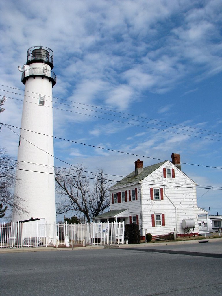
This free-standing pinnacle was composed of a conical brick tower encasing an 8.5 foot diameter interior brick cylinder. This formed a solid double-walled structure. The interior cylinder hosts a cast-iron spiral staircase that climbs to the lantern high above. The government built a separate two-story lighthouse keeper’s dwelling at the same time. Then they added a second residence in the 1880’s. Both structures are now privately owned. Additional technical information about the lighthouse and its outbuildings can be obtained through the Lighthouse Friends website.
A Second Chance
The Coast Guard deactivated the light in 1978. However, by then it was such a Fenck Island landmark that residents protested the decision and demanded its relighting. As a result the Coast Guard transferred ownership to the State of Delaware who in turn leased it to a nonprofit organization. The light returned in 1982. The New Friends of the Fenwick Island Lighthouse continues to lease and maintain the structure, and their efforts have kept it lit every since. Their website is located at fenwickislandlighthouse.org. Today the Fenwick Island Lighthouse is both a museum and a private aid to navigation.
Readers who have an interest in lighthouses might also want to check my Lighthouse Index page.
The Transpeninsular Line

A waist-high stone marker sits directly in front of the Fenwick Island Lighthouse. It juts from the brick sidewalk just steps away from the curb on the north side of Ocean City’s 146th Street. This signifies the border between the states of Maryland and Delaware. It also marks the eastern terminus of the Transpeninsular Line. Surveyors marked that line between 1750 and 1751 to settle part of a long-standing, conflicting land grant dispute between the Calverts and the Penns.
The Calvert family controlled the colony of Maryland through a 1629 charter granted by King Charles I to George Calvert, 1st Lord Baltimore. The Penns controlled Delaware (the “lower counties,”) separate from Pennsylvania starting in 1682. Early colonial boundaries, unfortunately, were not exact and royal grants sometimes overlapped. This led to conflicts as the colonies began to grow and prosper.
Surveying a Boundary
John Watson and William Parsons of Pennsylvania and John Emory and Thomas Jones of Maryland were commissioned to survey a straight line directly across the Delmarva Peninsula as part of an official demarcation. The Calverts, the Penns and then eventually the English crown all accepted the eastern half of the line as a border between Maryland and Delaware. Further details can be found on Wikipedia’s Transpeninsular Line page.
The Transpeninsular Line is not part of the more famous Mason-Dixon line which resolved the majority and the remainder of the contradictory land claims between the Calverts and the Penns. The Transpeninsular Line had already been established and accepted before Charles Mason and Jeremiah Dixon began their legendary boundary survey between Pennsylvania/Delaware and Maryland in 1763. The two lines do touch at a single point, however, with the southern terminus of the Mason-Dixon Line joining the Transpeninsular Line at its approximate midpoint. The joining of the two lines forms modern Delaware’s southwestern corner. This perhaps can be better understood on the rough map I’ve added immediately above by clicking either the red line, blue line or blue marker.
The photograph of the marker above is taken in Maryland, facing north into Delaware. The symbol carved into the uppers section of the stone displays George Calvert’s coat of arms and signifies that anything on that side of the stone belonged in Maryland. The same symbol forms the basis of the modern Maryland State Flag.
Still Standing

The Town of Fenwick Island claims that this marker is “the oldest standing man-made object on the coast between Indian River and Ocean City.” It likely survived because the surveyors had sufficient foresight to place it about a quarter mile inland so that it would not be swept away by tide or storm. More than 250 years later it’s still there and it’s in remarkable shape for its age. This view shows the Delaware side of the marker, facing into Maryland. The bar with the three circles is a detail from the coat of arms of William Penn, so anything on this side of the marker belonged to Delaware.
Leave a Reply