
Today’s post serves no useful, practical purpose. Check back in a couple of days if you want something more intellectually challenging. Feel free to hang out if you’re still nursing the after-effects of your New Years Eve revelries. I’m fine either way.
Regular readers know that I sometimes find topics by combing through search terms that visitors use to find this website. Lately I saw a recurring query that seems to boil down to something like this: “What is the fewest number of states necessary to cross the width of the United States?”
I’m not sure why this matters. Maybe these people harbor irrational fears of “Welcome to [insert state name here]” signs. More likely, some middle school teacher put this question on a take-home project over the Holidays. The kids would rather consult the Great Google than pull out a map. Lazy brats. Nonetheless, and in a sense of decency, fairness and generosity, I’ll provide an answer for the masses.[1]
SEVEN.
Getting There
First, some ground rules. The route must go from ocean to ocean. It cannot leave the Lower 48 and return. No fair cutting up to Vancouver and heading towards Toronto. Colluding with Canada must be prohibited. Sneaky Canadians.
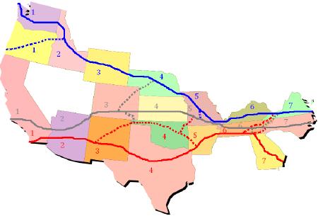
The number of states in the solution didn’t surprise me. However, the variety of feasible paths really did. We could take a northern route (WA, ID, WY, NE, MO, KY, VA). Likewise I found a southern route (CA, AZ, NM, TX, AR, TN, GA). Finally, how about a middle route (CA, AZ, CO, KS, MO, TN, NC)?
All sorts of variations, mixes-and-matches, and permutations existed that accomplish the same thing. The answer always remained SEVEN. I think my favorite one involves the Arizona-Colorado route because it squeezes through a single point. This path would have to be done on foot and would require some dexterity to avoid Utah and New Mexico, not to mention some wandering through the desert.

Number of Solutions
How many paths provide this solution? A lot. Remember back in school when they gave you that drawing of nested squares and you had to count all the squares and you always forgot to count the one that went all the way around the border? Right. I hated that one too. That’s how I felt when I was trying to figure out the number of paths.
Feel free to count them up and post the answer in a comment if “a lot” doesn’t meet your definition of precision. My deductive reasoning skills are a little lacking this morning. I’m sure the Christmas beers last night had nothing to do with it.
Alignment
The other aspect I found interesting was the way the numbers lined up vertically. The individual states feature various widths and yet they stacked so neatly. The natural inclination would be to leverage a really fat state like Texas to get that 850 mile swing from El Paso to Beaumont, and yet it provides no advantage for this exercise.
On the other hand it makes a huge difference in the eastern half of the country dominated by smaller states. The deep south (except Georgia), New England and much of the Midwest must be avoided. Likewise the Great Basin provides no outlet to the sea — just like the real thing — with Utah and Nevada vanishing from the map.
That involved way more virtual ink than this topic deserved.
12MC Loves Footnotes!
[1] Or what passes for masses on the Twelve Mile Circle. Face it, there aren’t too many of us who enjoy these little oddities. We’ve all been there — dragging uninterested family members to these geo-quirks and catching all sorts of grief for it. Oh, the indignities we endure.
Leave a Reply