
New technologies impact established disciplines in profound and pleasantly surprising ways. The Global Position System (GPS) provides obvious and well-known benefits for drivers and hikers alike. However, it has ready applications to many other activities too. As an example, handheld GPS devices continue to revolutionize field research conducted by personal historians and genealogists.
The Power of GPS
Without a doubt, libraries, courthouses and Internet resources contribute greatly to family tree discoveries. Nevertheless, a serious researcher will need to walk in the literal footsteps of his or her ancestors eventually to truly understand and absorb the greater context.
GPS is particularly powerful because genealogists are a generous bunch who want to share their discoveries with “cousins” whether alive today or born a hundred years from now. Addresses change, roads move, houses fall, and tombstones sink below the dirt. Yet longitude and latitude transcend time.
A coordinate recorded in the field on a handheld GPS today will locate a valuable waypoint next week or next century. Family historians can record their findings in near perpetuity when GPS coordinates are combined with resources like the Internet Archive.
Practical Examples
I will demonstrate how GPS overlays geography and mapping atop genealogical research with a trio of simple examples. This is intended to offer some promising possibilities. My personal interest happens to be genealogy but these same methods could extend easily to other interests or hobbies.
The Old Howder Homestead
The first example highlights a place, in this case a homestead. Various Nineteenth Century census records identified the George Howder family in Cambria Township, Niagara County, New York. Archived township maps outlined property boundaries.
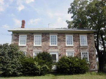
So I used a GPS device in the field to record the exact location of the circa 1839 house. Now any researcher can enter the coordinates into readily available mapping software. Then he or she could retrieve door-to-door driving directions, and travel directly to the Old Howder Homestead.
And here it is at 43.183639,-78.773806.
The Witte Outhouse
The second example is also an object, but perhaps a bit more colorful. It is a three-holed outhouse or privy. Each hole fit a particular family member. Without getting too descriptive, a hole might meet the needs of dad, mom or the kids. Our ancestors did not have flush toilets in this sparsely settled agrarian community on the nineteenth century American frontier. Outhouse served a necessary function. Nonetheless, few of these structures survived, having met with obsolescence, embarrassment or decay with the advent of indoor plumbing.

The Witte Outhouse dated to about 1873-1880. My wife’s extended family donated it to Old World Wisconsin,a living history museum in the southeast corner of the state. Imagine trying to find this one small building set obscurely upon the several hundred acres of a sprawling outdoor museum in the summertime heat. I can because I did. It was a difficult task even though I knew I should look somewhere in the German section of the facility.
Now imagine how much easier it would be to preloaded 42.866083,-88.497472 into a handheld GPS device. Today that is possible because I recorded the coordinates and released them to the public domain.
Sylvester Family Cemetery Plot
Finally I’ll highlight the classic example: grave location. Many genealogists like to record the exact location of their ancestors’ burial plots. I’m not exactly sure why we do this but it’s very common. I’ve certainly spent my fair share of hours wandering through cemetery fields in search of specific stones. This can be a daunting task.
Large cemeteries often have offices that will provide a paper map or at least a plot number to help narrow down the search. Smaller cemeteries generally do not, and researchers have no choice but to zig and zag down each row individually looking at every tombstone until reaching the right one. We could avoid all of this inconvenience if a previous visitor simply records a longitude and latitude.
A waypoint displayed on a handheld GPS will locate a tombstone to within a few feet. In the illustration above, the map clearly shows where I’ve marked the Sylvester Family Plot at 44.169333,-92.173778. This isn’t just a cemetery in rural Plainview, Minnesota, but a specific spot within that cemetery with an accuracy of about 15 feet.
Leave a Reply