
Germany (August 1999)
Many years ago we got an opportunity to drive from Belgium to Luxembourg to Germany. The Germany portion cut through the state of Rhineland-Palatinate, from the Luxembourg border to the Rhine River.
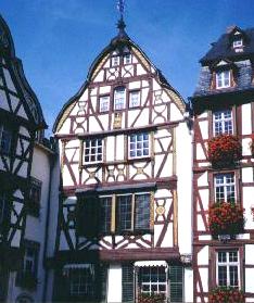
The Marktplatz at Bernkastel-Kues
We drove up from Trier along the spectacular Moselweinstraße (Mosel River wine road). The route crossed back and forth along the meandering Mosel from one small town to another. Lush vineyards climbed skyward from the valley on both sides of the river for fifty miles or more. Each hamlet seemed to have its own little wine festival proudly advertised with banners at its entrance.
By mid-day we reached the dual towns of Bernkastel-Keus set astride opposite banks of the Mosel (map). We concentrated on Bernkastel and its lovely Marketplatz. Bernkastel has done an excellent job of preserving its past. Many of the building looked as historic and well-preserved as the one pictured above. Much of the town was reserved solely for pedestrian traffic since some of the roads were only a few feet across!
Dining in Sankt Goar
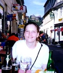
Next we cut across to the middle Rhine region, using St. Goar as our base for the next few days (map). Burg (“castle”) Rheinfels, now a ruin, towered over the bluff and once controlled the river in ancient times. We enjoyed leisurely strolls throughout St. Goar, Burg Rheinfels and along the riverbank. We dined at restaurants with outdoor tables set along the main shopping street.
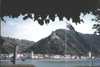
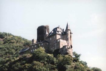
Burg Katz in St. Goarshausen
Burg Katz clung to a rocky ledge high above the town of St. Goarshausen along the eastern bank of the Rhine River, where joined by the Hasenbach Valley (map).
A Commanding Location
The full name of this citadel is actually “Neukatzenelnbogen” in deference to the Count von Katzenelnbogen who built the castle at this spot in the later half of the 14th Century. The English translation equates roughly to the “new castle of Katzenelnbogen.” Whether English or German this is a mouthful. Local residents shortened the name more reasonably to Burg Katz. This translates to Castle Cat so it’s indelibly tied another local castle, Burg Maus, which means Castle Mouse.
Burg Katz originally served both economic and military purposes. Then as now, the Rhine provided a transportation corridor through the German countryside. This was an ideal spot to extract fees from merchants moving along the river or tolls from passengers wanting to cross between St. Goarshausen on the eastern bank and St. Goar on the west. Militarily, this was a commanding location on a well-protected niche upon a steep rock wall. It also contributed to a key defensive perimeter when combined with other nearby fortifications.
But Also an Attractive Target
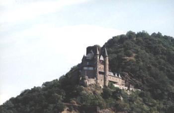
Well protected or not, this was an attractive target. Spaniards conducted a siege in 1626, and the French tried to capture it in 1684 and again in 1692. In 1795 the castle passed from the house of Hesse-Nassau to Hesse-Kassel, and then to the French in 1801. Napoleon chose to blow it up in 1806 and it remained in disrepair well into the late 19th Century when popular interest in castles grew among members of the upper class. It is obvious from these photographs that the “restoration” was intended to meet an idealized definition of how a castle should appear rather than an accurate rendition of the original 14th Century structure.
Hiking Up
A hiking trail led up from the back of St. Goarshausen, a hamlet occupying a narrow plain between the Rhine and the valley wall it carved from solid stone over eons. The steep, shaded path climbed hillsides and curled through switchbacks, eventually terminating on a flatter plateau above the Rhine River valley. Burg Katz had been built into the same steep hillside. We found increasingly closer views of the castle as we climbed upward. At one point we crossed the driveway that led into the castle but we continued towards the summit.
Awesome Vista
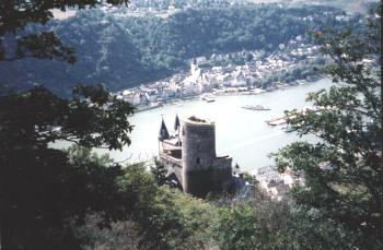
We were rewarded with incredible views of the Rhine upon arriving at the hilltop. Burg Katz appeared in the foreground, perched on its precarious rock ledge high above St. Goarshausen and the river. We watched barges move their cargo slowly along this watery highway as a ferry darted to St. Goar on the opposite bank. We rode that ferry only an hour earlier and it was odd to see this same sight from high above. We had the trail totally to ourselves during our entire climb and descent, and never once saw another person until we returned to St. Goarshausen.
Leave a Reply