
There are 77 Counties in Oklahoma – “The Sooner State“
Also be sure to see my United States County Counting Page for the rest of the states.
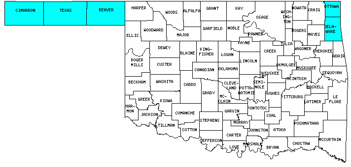
I have visited 5 Counties = 6.5% of Counties in Oklahoma
Counties visited are colored-in; counties still needing to be visited are blank. Map created using Mob Rule.
Twelve Mile Circle Articles Featuring Places in Oklahoma
Markers designate the Oklahoma locations featured in Twelve Mile Circle articles.
Counties in Oklahoma

Below are the 77 counties in Oklahoma. Although infrequent, counties sometimes do change so please let me know if any of this information is out of date and I will update it. Those counties that I have visited are highlighted in Red. Readers can also link to any articles manually in this section if the map isn’t working.
- Adair
- Alfalfa
- Atoka
- Beaver: 100th Meridian Counties
- Beckham
- Blaine
- Bryan
- Caddo: Middle of Nowhere
- Canadian: Random Canadian
- Carter: Town of County Line
- Cherokee
- Choctaw
- Cimarron: Smallest county population in Oklahoma (3,148 people in 2000 Census); CO-KS-OK Tripoint; Oklahoma Highpoint Trailhead; Highpoint, Not Summit; Cimmy the Dinosaur; NM-OK-TX Tripoint; Thelma and Louise Route Map
- Cleveland
- Coal
- Comanche
- Cotton
- Craig
- Creek
- Custer: Weatherford Art Thou?
- Delaware: Jay, OK; County with (Another) State’s Name;
- Dewey
- Ellis
- Garfield
- Garvin
- Grady
- Grant
- Greer: Going Postal; Old Greer County
- Harmon
- Harper
- Haskel
- Hughes
- Jackson
- Jefferson
- Johnston
- Kay
- Kingfisher
- Kiowa
- Latimer
- Le Flore
- Lincoln
- Logan: Orlando (not that one)
- Love
- Major
- Marshall: Smallest county in Oklahoma (371 square miles).
- Mayes
- McClain
- McCurtain: Red River Border
- McIntosh
- Murray
- Muskogee
- Noble
- Nowata
- Okfuskee: Last Chance; Triple Letter
- Oklahoma: Largest county population in Oklahoma (660,448 people in 2000 Census); Oklahoma City National Memorial; Woodlawn Park; Thelma and Louise Route Map; Black Gold; Longest Distance – Simplest Directions; Mmm… Doughnut
- Okmulgee
- Osage: Largest county in Oklahoma (2,251 square miles); Osage Nation; Black Gold
- Ottawa: The Death of the Town of Picher; The Smallest Tribe; Hornet Spook Light
- Pawnee
- Payne: Pipeline Crossroads of the World
- Pittsburg
- Pontotoc
- Pottawatomie: Quad County Towns
- Pushmataha
- Roger Mills
- Rogers
- Seminole
- Sequoyah
- Stephens: Town of County Line
- Texas: Mainly Marathons
- Tillman
- Tulsa: Follow the Letter; Seriously Broken
- Wagoner
- Washington: More Presidential County Sorting
- Washita
- Woods
- Woodward
Quick Facts About Oklahoma
- Location: West South Central United States. See map above.
- Size(1): 68,595 square miles. Oklahoma is the 19th largest state. The next larger state is Missouri and the next smaller state is Washington.
- Population(2): 3,960,079 people. Oklahoma is the 28th most populous state. The next more populous state is Oregon and the next less populous state is Connecticut.
- Population Density: 57.7 people per square mile. Oklahoma is the 35th most densely populated state. The next more densely populated state is Arkansas and the next less densely populated state is Iowa.
- Bordering States: Oklahoma shares a border with 6 states: Kansas; Colorado; New Mexico; Texas; Arkansas and Missouri.
- Admission to the Union: November 16, 1907. Oklahoma was the 46th state admitted to the Union, after Utah and before New Mexico.
- Capital: Oklahoma City.
- Highest Point: 4,975 feet at Black Mesa. See SummitPost’s Black Mesa page.
- Lowest Point: 289 feet at the Little River in McCurtain Co.
- Government website: Welcome to Oklahoma’s Official Web Site.
- Official Tourism website: TravelOK.com: Official Oklahoma Tourism Info. Site.
- Still not enough? See Wikipedia’s Oklahoma page.
Sources:
(1) Wikipedia: List of U.S. states and territories by area. Land area only.
(2) Wikipedia: List of states and territories of the United States by population. Estimated population on July 1, 2019.
Leave a Reply