
The final article of 2015 felt like an appropriate time to reflect upon my personal geographic sightseeing adventures during the past year. I accomplished a lot in 2015, more than typical, and I recalled my travels fondly. Plus I figured that readership always dropped way off during the slow week between Christmas and New Years. So it didn’t really matter what I published. This seemed as good a time as any for a clip show. I can take a little mental break while offering an opportunity to wax nostalgic and share a few favorite photos. All images in this article were my own for once.
Great Allegheny Passage
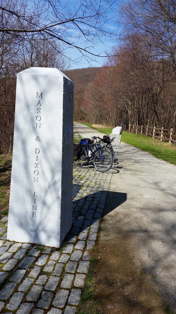
It seemed like ages ago when I climbed atop my bicycle and set off on a 150 mile ride (240 kilometres) from Pittsburgh, Pennsylvania to Cumberland, Maryland with a couple of friends. I kept reminding myself that it was only last April. The quest seemed daunting although we spread it over multiple days, and we pedaled a nice, easy pace.
The Great Allegheny Passage trail followed rivers for the most part. We got to know the Monongahela, Youghiogheny and Casselman, pushing through mountainous valleys and woodlands. The passage also crossed a couple of notable geographic features. This included the Mason & Dixon Line at the border between Pennsylvania and Maryland. We also crossed the Eastern Continental Divide (photo) where water flowed either to the Atlantic Ocean or to the Gulf of Mexico.
Cape Cod and Nearby

Geo-oddities weren’t a primary objective of my adventures along Cape Cod and Nearby. Anyway, I suppose the closest object that fit the definition might have been Plymouth Rock. I’ve talked before about its dubious historical claim and its underwhelming presence. Still, it was Plymouth Rock for cryin’ out loud. That counted for something.
A large glacial erratic known as Doan Rock (photo), perhaps the largest Ice Age wanderer on Cape Cod, actually impressed me more. The trip wasn’t a total geographic bust by any means. I did manage to snag several new counties including two requiring ferries (Nantucket and Dukes). Additionally, I finished the remaining counties in Rhode Island.
Oh, and I also experienced a lot of great stuff that had nothing to do with geography.
Western North Carolina

Some journeys seemed to lend themselves better to collecting notable geographic peculiarities. For me, that wonderful confluence of events happened naturally during July’s trip to western North Carolina. I captured two new state highpoints, Mount Mitchell in North Carolina and Clingmans Dome in Tennessee. Neither required anything special beyond minimal “climbing” from parking lots near their respective summits. That was a real bonus for someone of my sluggish tendencies. I also ate lunch at Famous Louise’s Rock House Restaurant. It may or may not actually straddled three county lines simultaneously (photo).
Yes, of course I realized I strayed across the border into Tennessee so it wasn’t technically a trip dedicated solely to western North Carolina. In my defense, the boundary between the states cut directly through the summit of Clingmans Dome. The mountain was tall enough to be Tennessee’s highpoint although not for North Carolina. Mount Mitchell reached 41 feet (12 metres) higher than Clingmans Dome and it was also the highest peak east of the Mississippi River. I needed to visit both of them.
Really? I didn’t actually need to visit both of them, and I probably wouldn’t have if they’d been more troublesome.
Center of the Nation

Naturally I’d expected something particularly significant from a Mainly Marathons event named specifically for a geographic feature. The Center of the Nation adventure didn’t disappoint. Indeed, I was able to experience one of the more notable “centers of the nation” in South Dakota which tend to vary depending on how one defined center. I also saw a completely false center established at a more accessible location a few miles away at a park in the town of Belle Fourche (photo) just for good luck. If that weren’t enough I then drove through the nation’s smallest county seat of Amidon, North Dakota (photo). In reality, it had been eclipsed recently by an even smaller county seat in Nebraska.
County Counting

I had a banner year for County Counting in 2015. I don’t recall exactly how many new counties I added and I’m too lazy to figure it out. Even so, a quick scan led me to believe it was probably somewhere around fifty. My travels were good enough to bring my lifetime total up to 1,302, or 41.4% of counties in the United States.
The final capture of the year happened only a few days ago. I had to get out of the house for a couple of hours while visiting the in-laws in Wisconsin. I actually have great in-laws — that wasn’t the problem — I still needed to wander somewhere after sitting around the house for five days. You know how that goes. I drove just far enough to cross the border into a doughnut hole county that had been tormenting me for several years. Green Lake County, you were mine!
Skellig Michael

The final geographic moment actually didn’t happen this year, it happened in 2014 when I visited Ireland. However it made its screen debut in December 2015 so I counted it as an achievement for the current year.
We’d traveled to remote Skellig Michael (map). That’s a rocky islet jutting from the sea a few kilometres from the southwestern edge of the Irish mainland. A filming crew for Star Wars VII: The Force Awakens visited that same spot coincidentally a few weeks later. Skellig Michael appeared in the movie at its release a year and a half later.
I won’t provide any spoilers for the one or two 12MC readers who may not have seen the movie. However, I will note that Skellig Michael served as the setting for the very final scene at the end of the movie. Also, it will likely appear again at the beginning of its sequel.
I marveled at how the crew managed film around thousands of puffins that made the island home because those birds were literally everywhere. Viewers can see scattered puffins flying around on a few shots in the distant background of the movie. I swear I spotted at least one puffin burrow that the editors somehow missed although I couldn’t be sure. I’ll have to look more carefully the next time I watch it.
Leave a Reply