My Travel Box

It struck me that I’d gone really north and really west when I went to Alaska, perhaps the farthest I’d ever been in either direction. That made me wonder about the most extreme latitudes (north/south) and longitudes (east/west) I’d visited during my lifetime. I was wrong on both counts by the way; Alaska was neither greater north nor west than other places I’d visited before, but I still enjoyed figuring it out.

I calculated the four extremities to create what I call my “travel box.” It demonstrates graphically that I have to work harder if I want to travel to greater extremes in latitude or longitude.

My extreme latitudes and longitudes of travel; created using Google Maps
My Latitude and Longitude Extremes

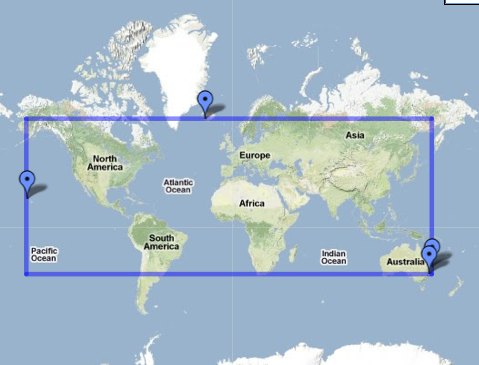
This is a screen print, not the usual interactive Google Map. I tried, but Google had trouble displaying it properly. You can try it out yourself if you like. I grew frustrated with it after attempting to get it to embed correctly for about an hour.

You’ll notice four push-pens on the map. Those are anchors representing my four extreme points. North and South have the most meaning to me. East and West are arbitrary because it’s based on the Prime Meridian which is an artificial construct. People living in England are going to have a hard time scoring well on east-west differences, but that’s what they get for stealing the Prime Meridian. I call it payback. Just kidding. On the other hand, people at the tail end of the Aleutian Islands have it made.


North

Tjörnin, Reykjavík, Iceland. Photo by howderfamily.com; (CC BY-NC-SA 2.0)
Tjörnin in Reykjavík, Iceland

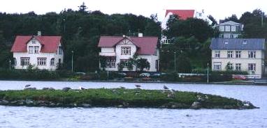
The farthest that I’ve ventured North is Reykjavík, Iceland at 64.14° N.

Talkeetna, Alaska. Photo by howderfamily.com; (CC BY-NC-SA 2.0)
Forty Miles from Denali in Alaska

As I mentioned, it was not Alaska. I got only as far as 62.27° N. on the southern edge of Denali State Park. Forty miles from the highest point of North America? Hmm… you tell me. This vantage was supposed to provide an awesome view of the mighty peak but all I saw of Denali (Mt. McKinley) was a great white wall of clouds. It could have been as flat as a pancake for all I know.


South

Taronga Zoo, Australia. Photo by howderfamily.com; (CC BY-NC-SA 2.0)
Sydney viewed from the Taronga Zoo

I have no problem figuring out my most extreme southern travel. It was Sydney, Australia. I encountered a little surprise when I calculated the exact spot. It’s a runway at Sydney Airport, at 33.97° S. This is the most feeble of my extremities. I live in the northern hemisphere so I’m at a natural disadvantage on this one. Our readers in Australia and South Africa, and there are several of you, have a good start on this one simply by birthright.


East

Cape Byron, Australia. Photo by howderfamily.com; (CC BY-NC-SA 2.0)
Lighthouse at Cape Bryon

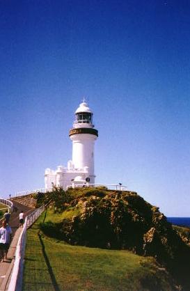
Wow, I’m back in Australia again. This example is a little better than the airport runway though. It’s a genuine geo-oddity, the easternmost point on mainland Australia: Cape Byron in New South Wales. The lighthouse located on the cape extends to 153.64° E. Australians have a good start on this game especially if they live in southeastern corner of the country. New Zealand has it even better.


West

Kauai, Hawaii. Photo by howderfamily.com; (CC BY-NC-SA 2.0)

Finally, looking west, my most extreme location is Koke’e State Park on the island of Kauai, Hawaii, USA, which equates to 159.68° W. It wasn’t the Alaskan geo-oddity at Anchor Point that I covered in a previous article, and that was too bad, but it was another dis-attached part of the United States so I’m fine with it.

Anchor Point, Alaska. Photo by howderfamily.com; (CC BY-NC-SA 2.0)
Anchor Point on the Kenai Peninsula, Alaska

Latitudes range from 0° at the equator to 90° at the poles, a total of 180. Mine is 64.14 + 33.97 = 98.11, or 55%. I have lots of room for improvement here.

Longitudes ranges from 180° on both sides of the Prime Meridian, a total of 360. Mine is 153.64 + 159.68 = 313.32 = 87%. That’s quite a bit better.

How did you do? How big is your travel box?


Posted

in

, ,

by

Comments

8 responses to “My Travel Box”

  1. Mark Sundstrom Avatar

    A favorite topic of mine. I have different sets depending on the criteria.
    Overall extremes:
    North – Skagway, Alaska N59.5
    South – Costa Rica N8.5
    East – Sweden E13d 55m
    West – Kekaha, Kauai, Hawaii – W159d 45m

    Extremes in North America:
    North and West – Skagway N59.5 W135.3
    South – Costa Rica N8.5
    East – it was Barbados, W59.5, but I got pretty close in Nova Scotia last year at N59.9

    Extremes in the 48 states:
    North – Canadian border at N49
    South – Key Largo, Florida N25
    West – Cape Blanco, Oregon W124d 33.84m
    East – Calais, Maine W67.3

    And I flew over Iceland (N65) on a flight from Copenhagen to Chicago, but I don’t really count that.
    –Mark

    1. Twelve Mile Circle Avatar

      Your mention of Iceland reminds me of my "trip" to Greenland. 🙂

  2. Hamish Avatar
    Hamish

    I think your point about east/west screwing people in England is a fair one. Simply living on the west coast I will get a wider East/West score than someone living in France – judging on basic travel patterns. I think it would be more valid to use your own residence as your own prime meridian. I would use 77 02 west as your base (that’s DC right) and that puts both your east and west points in “your” western hemisphere.

    1. Twelve Mile Circle Avatar

      That’s totally fair. I’m going to redo my analysis except in a universe where the American Meridian — which ran directly through Washington, DC — had been adopted as an international standard rather than the Prime Meridian in Greenwich, England. Stay tuned! This should be fun.

  3. Scott Z Avatar
    Scott Z

    Good to see I’m not the only one doing this. I’ve kept track of my travel extremities (among other travel-related things) for years. I’ve been using hand-drawn lines on a printed outline map of the world to depict the extremity points. Ironically, I’m a professional cartographer.

    -Scott

  4. Colin Avatar
    Colin

    My most northerly travels were to Helsinki (60N), my southerly most was to Hobart (43S). I’ve been to Auckland as my easterly point (175E), and Haida Gwaii as my westerly point (132W) (I have gotten off of a plane into the airport in Hawaii, but I don’t count that). My N/S range is 103 degrees or 57%, and my east/west range is 85%.
    I live in Port Hedland (119E), in Western Australia. My antipodes longitude is 61W, which passes pretty close to Halifax. The closest I’ve gotten on either side of that is New York (74W) and Tralee (10W). On that scale I’ve only covered 82%. Still, not bad.

  5. Anton Sherwood Avatar

    My nerdy preference is to consider the convex hull of my travels. (You get to call yourself a world traveler if your convex hull contains the Core. That’s not likely to happen for me.)

  6. Simmon Clark Avatar
    Simmon Clark

    Cool! I simply loved the description you have provided of all the four corners of the world. I am particularly keep to go to Iceland. I really wanna see what it is like… We hear about many countries for good and bad things but Iceland never comes up with either terrorism or a film festival or a fashion week….

Leave a Reply

Your email address will not be published. Required fields are marked *

Latest Comments

  1. Technically it’s not always correct to say EST/CST, etc…. but just an indication that I’m changing time zone is enough,…

  2. In general, I wonder why navigating from the Atlantic Ocean to the Black Sea doesn’t count as inland navigation.

  3. Re: East/West Carroll parishes, you’re close, but the real reason for the split was more political than demographic or cultural.…