
If one ponders a map of the United State’s and focuses on one of its four Commonwealths, specifically Pennsylvania, one will notice something a bit odd with its borders. The northern, southern and western borders all form straight lines of exact longitude or latitude. However there’s an exception, a little notch at the far northwestern corner. That is the Erie Triangle, which I’ve marked in blue on the map, below.
The reason is the obvious, and exactly as one would expect. Pennsylvania wouldn’t have a seacoast (OK, technically a “lakecoast”) without it.
Initially Blocked
When the United States gained its independence, Pennsylvania was a very large and powerful entity. However, it had a problem. As this detail from a 1789 map shows (below), Pennsylvania did not include an outlet to Lake Erie.
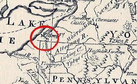
This might harm the Commonwealth’s long-term economic and political power. During this era, waterways provided the most reliable means of transportation and trade. A weak Pennsylvania would not benefit the new Nation either. Pennsylvania needed a port city to the west but direct access to the Great Lakes wasn’t possible. Settlements had already begun to move westward towards the continental interior. The state needed a connection to the freshwater coasts of the Great Lakes.
A Geographic Problem
New York’s original charter established its western border at 20 miles east of Lake Erie’s Presque Isle Peninsula. Pennsylvania’s northern border had also been established by charter, and it ran along the 42nd Parallel. This created an anomaly at the dawn of the new nation, a no-man’s-land aside Lake Erie known as the Triangle Lands. It belonged to neither New York nor Pennsylvania. Thus it fell within the United States but outside of any specific state.
New York would seem to be the most obvious claimant. Just extend its western border another twenty miles to the shores of Lake Erie. However, Massachusetts and Connecticut countered that they also had legitimate claims to the area. Their colonial era charters granted lands forever westward, from sea-to-sea. Rightfully, lands not specifically carved out for New York should belong to them, or so they claimed. Draw a line of latitude due west from the Massachusetts/Connecticut border and guess where it goes? You guessed it, right through the Erie Triangle.
The Solution
What was a new government to do? Multiple states felt they either deserved or required the Triangle Lands. However only one of those states was landlocked, and it would be detrimental for Keystone State to become economically isolated. The fledgling government exerted its persuasive authority and pressed all four states to relinquish their claims to the Erie Triangle. Thus, the Federal government and no individual State became its rightful owner. It then turned straight around and sold the land to Pennsylvania for a little more than $150,000 (quite a bargain at 75 cents an acre!) in 1792. Pennsylvania got its freshwater port and named it Erie.

I’ve been lucky enough to visit this geographic anomaly. A few years ago I traveled through the area and recorded my visit to Presque Isle State Park, the peninsula that juts out into Lake Erie from the Triangle Lands. It’s actually quite lovely and serves a remarkable contrast to the nearby industrial port city.
One doesn’t normally equate Pennsylvania with sandy beaches and lighthouses. Nonetheless, the historic events of the Erie Triangle made this possible.
Leave a Reply