
A random Twelve Mile Circle reader became an unwitting inspiration for this article simply because of where he or she lived. The little dot within Idaho on my Google Analytics dashboard mentioned State Line. That seemed too good to be true. I’ve done plenty of articles about border towns although I’d never noticed that one before. It sounded like a good excuse to peel things back a layer and take a closer look.
State Line, Idaho
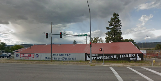
State Line didn’t cover much of area and only 38 people lived there (map). It seemed an odd situation until I uncovered a bit of history in an old newspaper article. This creation sprang to life in 1947 and existed for a very specific reason. Quite simply, “the town was incorporated so it could sell liquor and have slot machines.” End of story.
Those who incorporated the town leveraged the adjacent state border, just enough over the line to fall outside of the laws of Washington State. Residents of the region’s dominant city — Spokane, Washington — needed only a short drive to take advantage of the more liberal drinking and gambling rules of Idaho.
Apparently incorporated towns in Idaho had some legal leeway to provide these services so State Line filled that niche. The town didn’t have to worry about do-gooders interfering with its business either; it carefully corralled a sympathetic population. I’ve explored similar themes before, e.g., in Right Up to the Line.
A lot of separate sins packed into that tiny package, too. I drove down Seltice Way, the main road through State Line, vicariously using Google Street View. From the border heading into Idaho I noticed a smokeshop, a liquor store, several taverns including a biker bar, and a building with no windows advertising “Show Girls.” I wonder what could possibly be going on inside there? This is a family-friendly website so I’ll leave it at that. I also found the residential area consisting of a small trailer park. Maybe the show girls lived there? If so then one of them visited 12MC and landed on the Thelma and Louise Route Map. Maybe someone was planning a weekend getaway?
Stateline, Nevada
Idaho didn’t contain the only town with that familiar name. Stateline existed in Nevada, too. I talked about that one briefly in the Loneliest Road in the USA and it appeared in reader comments from time-to-time as well.
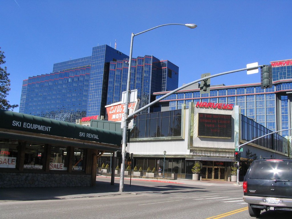
South Lake Tahoe, on the California side, seemed like an average ski resort town. A gondola led up the slopes within the Heavenly Mountain Resort. However, Nevada beckoned just down the street. Five humongous casinos rose starkly from the pavement barely inches onto the Nevada side of the border. This grouping represented the same basic premise as its Idaho counterpart, bringing convenient “sinful” businesses closer to the masses.
Additionally, a morbid geo-oddity of sorts existed in Stateline. The ski resort included trails on both sides of the border. So skiers crossed the state border on several of the runs. That was a worthwhile oddity by itself of course, although that wasn’t the morbid part. Something awful happened there in 1998. That’s when Sonny Bono, the lesser-known half of Sonny and Cher, slammed into a tree on the Orion slope (map). Bono died in Stateline on a border-crossing trail.
Stateline, Kansas
Stateline also existed as one of thirteen townships in Sherman County, Kansas. The name went back historically to the 19th Century and simply represented its geographic placement next to Colorado. Stateline didn’t exist to entice people across the border and only 344 people lived there in the most recent Census. The township contained only one settlement of any size, Kanorado (map), the home of about half of Stateline’s residents. That still made it large enough to serve as Sherman County’s second largest town.
My attention automatically focused on that spot because, as longtime readers know, I love a good portmanteau. The name combined and shortened Kansas and Colorado into Kanorado. It’s website noted that someone originally called it Lamborn. I preferred Kanorado. Excellent choice.
This one existed within a bit of a geo-oddity. Only four counties recognized Kansas Mountain Time, including Sherman County. Of course that also included Stateline Township and the village of Kanorado. From my experience driving directly through there on Interstate 70 several years ago, I couldn’t determine why the area felt more aligned to Mountain Time. It seemed really remote, regardless. Either zone should be fine. Nonetheless residents apparently felt otherwise and aligned chronologically with Colorado.
Actually, as I thought about it more, Stateline should probably exist on the Colorado side instead. Colorado seemed to feature more sins than Kansas, particularly cannabis and perhaps alcohol too. The current Stateline alignment represented lost economic opportunities.
Others Even More Obscure
I found other State Lines and Statelines. For instance, check out State Line Pond in Connecticut. It also had its own website, believe it or not. From its description,
“State Line Pond is an approximately 75 acre lake in Stafford Springs, Connecticut on the Massachusetts border at Monson, MA. The lake was formed when a stream running through a meadow was intentionally flooded approximately 150 years ago. For many years, the Stafford Ice House ‘harvested’ ice by horse from the lake during the winter and delivered it to restaurants, homes and businesses as far away as Boston.”
Even more obscure places existed in the form of State Line, Mississippi and State Line, Indiana. I couldn’t find much about either place other than their existence.
Leave a Reply