
Loyal reader Scott sent me a message recently related to towns studded with enclaves outside of their jurisdiction. That specific topic sometimes generates discussion on Twelve Mile Circle (e.g., Mmm… Doughnut and the Gaithersburg Doughnut Hole). So he wished to bring an even more interesting situation to my attention.
He referenced the concept of Strip Annexation as practiced in Arizona. Towns rushed to create thin ribbons of land snaking through the desert that looped back upon themselves. This resulted in towns with massive county enclaves embedded within them.
Scott thought this might be a good story idea for 12MC. I did too but I wondered if I would be able to compile enough information to do it justice. Fortunately I stumbled upon “Border Wars: Tax Revenues, Annexation, and Urban Growth in Phoenix” by Carol E. Heim of the University of Massachusetts – Amherst, Department of Economics. The article first appeared in the International Journal of Urban and Regional Research in 2006, and is available online now. It’s a fascinating account of boundary changes in the Phoenix metropolitan area including the strip annexation phenomenon.
The Concept
Look at a map today and the Phoenix area appears nicely built-out as it marches into the desert. Infill development is a recent phenomenon. Growth and expansion began in earnest in the 1950’s, as detailed by Heim. Expanding towns started bumping into each by the 1960’s as they grew and jostled for position. Things turned ugly in the 1970’s, an era marked by a hostile strategy of “Preemptive Strip Annexation.”
Urban and suburban planners use strip annexation as a tool to support growth. Literally, a town or city claims a narrow ribbon of land that connects the main body of a municipality to an otherwise non-contiguous area considered economically desirable. The strip can be extremely narrow, even as slim as the width of a single road. Sometimes it’s also called flagpole annexation with the target area appearing as the flag waving on its shoestring pole. It’s not always pretty. The town can develop an odd octopus shape with tendrils twisting and extending into the countryside when done repeatedly.
Courts generally uphold the practice where it’s not explicitly discouraged or prohibited by local law. Of course that assumes it establishes a contiguous strip. The practice isn’t unique to Arizona either. For example, Chicago and Denver used it to connect their airports to the city. However, what makes it noteworthy near Phoenix is the severely dysfunctional form it took as the metropolitan area evolved.
Population Growth in Arizona
Residents continued to pour into Arizona during the latter half of the 20th Century. Many of them settled in Maricopa County and the Valley of the Sun. As a result, Phoenix expanded its borders frequently to harness that growth. Then the little towns around it began to shudder. They faced a genuine possibility of either being sucked into Phoenix or being so completely surrounded and constricted that they would wither on the vine.
The Loophole
So the laws of the time provided a novel loophole. One town couldn’t leapfrog over the area of another town, no matter how small the jump. As a result, municipalities could effectively block the territorial aspirations of their neighbors with the thinnest strips of land imaginable since annexations had to be contiguous.
That’s exactly what happened. It became like a giant game of chess with moves and counter-moves by towns to gain and block. Towns created narrow protective strips completely around themselves to stave off their enemies and preserve enclaves for their own future expansion. Borders went miles into the desert like moats surrounding castles.
Advantage Municipalities
It was a great bargain for the municipalities. They didn’t have to provide government services to the people trapped inside a county enclave created by strip annexation. At the same time they could and did incorporate parcels for development within their exclusive buffers over time.
They gained the ability to cherry pick. Maricopa County got stuck with the bill for providing road infrastructure, police and fire protection, and all the services required of widely-scattered citizens in the county islands. Meanwhile towns could incorporate any attractive parcels within the island at a later date as affluent subdivisions and shopping centers emerged (while ignoring the less-affluent), then reap resulting residential and sales tax windfalls. As with many things in life, it was about the money, in this case tax revenues.
Phenomenal Growth
Heim provided some excellent maps and tables explaining the growth in much greater detail. From Table 1 of that source, consider some of the following increases in square mileage between 1950 and 2005. These figures also include any county islands created by strip annexation.
- Phoenix: 16.09 to 515.10
- Mesa: 5.82 to 131.07
- Buckeye: 0.83 to 239.79
- Goodyear: 0.31 to 118.42
- Scottsdale: 0.00 to 184.43
- Peoria: 0.00 to 177.58
The Case of Gilbert
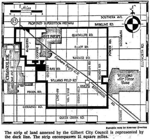
It reached a point of complete ridiculousness. Gilbert finally brought the practice to the forefront when it strip annexed a sizable territory as a preemptive check on Chandler in 1974. That’s not to say that Gilbert did anything different than several other towns in the Valley of the Sun. It simply served as a catalyst for an eventual demise of the practice. It was the largest preemptive strip annexation up until that time. Thus it became a proverbial straw that broke the camel’s back.
One would never realize that Gilbert sparked the demise of strip annexation in Arizona through its particularly brazen maneuver from the revisionist history presented on its website though:
“Gilbert began to take its current shape during the 1970s when the Town Council approved a strip annexation that encompassed 53 square miles of county land. Although the population was only 1,971 in 1970 the Council realized that Gilbert would eventually grow and develop much like the neighboring communities of Tempe, Mesa, and Chandler. This proved to be a farsighted decision as Gilbert positioned itself for growth in the 1980s and beyond.”
A Closer Look
A noble farsighted decision, then? Notice the 1975 map from the Arizona Republic reproduced above. Consider the strip was between 20 and 50 feet wide with a few select nodules of significant acreage. The largest nob filled most of the area bound by W. Warner, S. Gilbert, W. Ray and S. Cooper Streets. Lets take a closer look at that area today:
An interesting name appears as one compares the Arizona Republic Map with the current Google Map. The predominance of the shaded area is filled today by Dave Brown Millett Ranch, Dave Brown Country Estates and Dave Brown Lamoreaux Farms. That’s certainly not a coincidence.
The Arizona law at the time said that owners representing at least 51% of the assessed land value had to consent to the annexation. Gilbert’s strip encompassed knobs of supporters. However it extending narrow lines through land owned by non-supporters to effectively dilute their lack of consent. I will speculate but do not have evidence that the developer(s) of Dave Brown’s properties likely benefited handsomely when their desert lands suddenly became part of Gilbert.
Opposition
Two couples owned land bisected by the strip and opposed its annexation. This lead to a landmark legal case Glick v. Town of Gilbert heard by the Court of Appeals of Arizona in 1979. Here the owners raised a number of issued pertaining to fairness. These included the underhanded method used to determine consent and the unfavorable situation of owners stuck in the county island now encircled by the narrow annexation.
However, the Court of Appeals affirmed the judgement of a trial court. It ruled, “the alleged deficiencies raised by appellants to be insufficient to affect the validity of the ordinance.” In other words, the actions of the Town of Gilbert may have been greedy and deceitful but they were perfectly legal.
Legislation
Gilbert won the case but it became a glaring example of overreach that contributed to new legislation. Arizona prohibited strip annexation the following year, 1980. The State legislated further reforms that complicated future annexation in general in 1986. That didn’t halt annexation by Arizona towns but it slowed them down and prevented the more glaring instances.
Legacy
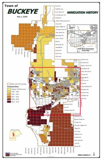
The legacy of strip annexation remains visible in numerous Phoenix-area towns today even though the practice has been abandoned for more than thirty years. Past annexations remained valid and towns slowly filled the county islands they created in the 1970’s. The Town of Buckeye provides an interesting case in point as it selectively incorporated parcels throughout the 1990’s and early 2000’s. This left Buckeye and similar towns shaped by strip annexation as if they were more akin to Swiss Cheese.
Thanks again to Scott for the great idea. I can’t always guarantee I’ll find enough information to create an article, but I always enjoy hearing suggestions from readers.
Totally Unrelated
Greater Greater Washington featured a video of all 50 state-named avenues as visited by bicycle. It’s a fun little video — check it out!
Leave a Reply