
Time moves forward, an unstoppable force. We all must face that awful truth as we age. On a happier thought, that allowed me to revisit a Twelve Mile Circle article from nearly five years ago. Maybe the conditions changed, or maybe not. Let’s find out.
In February 2010 I wrote Streetview Beats a Deadhorse. Back then I concluded that the northernmost Google Street View image correlated to a spot at 70.242777 degrees north latitude in the North Slope Borough of Alaska. The Dalton Highway went no farther, terminating at a restricted checkpoint of the Prudhoe Bay oil fields.
Forward to today, the final day of meteorological summer for the northern hemisphere 2014. Had the honor shifted? I established simple rules and expanded the search to all four cardinal directions. The site must have been visited by the actual Street View automobile. Someone aboard a ship or carrying a camera backpack wouldn’t count. That eliminated Antarctica, Svalbard and various isolated South Pacific islands.
Nordkapp, Norway
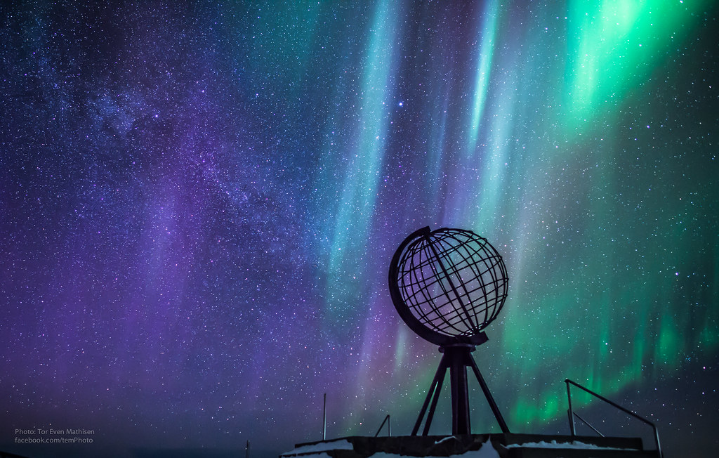
The northernmost crown had been stolen! It now shifted to 71.169475 degrees north, where the Street View car reached Nordkapp, Norway. All end-of-the–line Street View images were rather boring so I posted photos from Flickr instead. I still included a link for each entry for curious 12MC audience members though (for example, Street View).
Apparently lots of people consider Nordkapp a tourist attraction. They come because they consider it the northernmost point in Europe. I wouldn’t have the heart to tell them they’re all wrong.
Maybe it’s as far north in Europe as anyone can conveniently drive a car. European route E69 provides a well-maintained road right up to the the Nordkapp doorstep. Then tourists can disembark at a newly refurbished visitors center and snap lots of photos memorializing their accomplishment.
Interestingly, “Nordkapp is a Norwegianized form of the English language name North Cape.” A 16th century English explorer searching for a safe route through the Northeast Passage named it. Somehow the designation stuck.
Cochrane, Chile

Cochrane, Chile, extended to -47.258816 degrees south and claimed the southernmost image title (Street View). I fully expect that position to change some day. It’s only a matter of time before Street View arrives in Ushuaia, Argentina or Cabo de Hornos, Chile along the Beagle Channel of Tierra del Fuego (map). For today at least, Cochrane held the title.
Cochrane also seemed an odd choice for a place named in a Spanish-speaking area. Like Nordkapp, it demonstrated that British ship captains sailed far and wide across the planet. Cochrane referred to Thomas Cochrane, 10th Earl of Dundonald, from Scotland. He sailed relentlessly during the first part of the 19th century, experiencing one adventure after another. He also got into and out of trouble repeatedly. Think of him as an archetype of the swashbuckler. Numerous authors drew upon Cochrane as inspiration for their fictional characters forever thereafter.
Cochrane, the town, honored its namesake’s role as Admiral of the Chilean Navy, a position he also filled later for Brazil and Greece in addition to his years of service in the British Navy. The guy got around.
We should be thankful that the Street View car made it down to Cochrane. The Chilean southern highway (Carretera Austral) didn’t connect Cochrane and other southern towns to the larger road network until 1988. Even today it subjects drivers to curves, gravel and sometimes terrible weather.
The biggest tourist attraction — other than the abundant natural scenery of various large parks in the area — seemed to be the oddly-shaped Casa Mate.
East Cape, New Zealand

Easternmost and westernmost didn’t have the same appeal during my review because of the arbitrary nature of a prime meridian. I won’t spend as much time discussing them. A prime meridian could exist anywhere. Once again British sea power influenced events and Greenwich became a worldwide standard. Nonetheless I examined the situation anyway for the sake of completeness.
East Cape served as the easternmost point of New Zealand’s primary islands. It included Street View coverage up to the farthest point an automobile could travel (Street View). It would be difficult to ever improve upon 178.544347 degrees east. These images extended all the way to a car park where visitors could hike to the actual point.
“A 22km, mostly unsealed, no-exit road from Te Araroa takes you to the most Easterly point on mainland New Zealand. The historic East Cape lighthouse stands 154 metres above sea level and is accessed by a walking track of some 700 steps – worth it for the views at the top.”
Mana Point, Kauai, Hawaii, USA

Street View provided extensive coverage of the Hawaiian islands so it was only a matter of finding the westernmost image on the westernmost major island, Kauai. I also noted images from minor outlying islands along the archipelago. However, those didn’t involve automobiles or road networks so I discarded them. I settled on Mana Point on Kauai at 159.779397 degrees west (Street View).
The area was known for two things: surfing and missiles. It was the site of Pacific Missile Range Facility Barking Sands:
“…the world’s largest instrumented multi-environmental range capable of supported surface, subsurface, air, and space operations simultaneously. There are over 1,100 square miles of instrumented underwater range and over 42,000 square miles of controlled airspace.”
The updated Street View extremes delivered viewers to some interesting places. I wonder where they will lead another five years from now?
Leave a Reply