
I love it when categories collide and take me in entirely unanticipated directions. That’s what happened today. I noticed an interesting external search that bounced against my site: “What 2 state capitals are within 20 miles of a time zone boundary?” I’ve featured time zones many different times. I’ve also focused on the peculiarities of states. However I’ve never linked the two together so I decided to investigate this query further.
This should be pretty straightforward, I thought. Mapquest displays time zone markers and Google Maps provides a Great Circle distance utility. It shouldn’t take much effort to find the answers by toggling between the two.
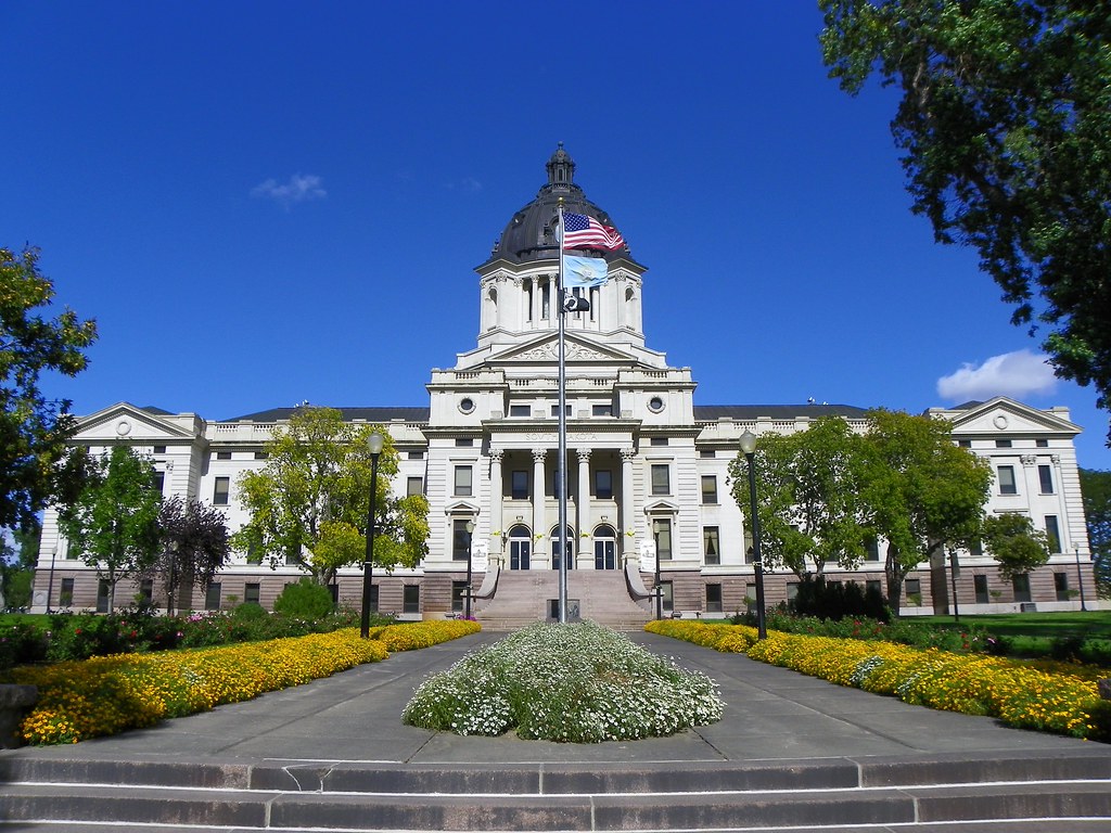
Pierre, South Dakota
Pierre, the capital city of South Dakota is the obvious initial choice that jumps right out (map).
I can’t find a handy map with the proper licensing to embed here. Fortunately, many examples can be found all over the Intertubes with your favorite search engine.
Pierre falls in Central Time. But a bridge over the Missouri River is all that separates it from Western Time. Perhaps the town on the western bank, Ft. Pierre follows Central Time informally (don’t know that for a fact but such affinity recognition is fairly common). Even it that’s the case it’s hard to imagine a scenario where Pierre doesn’t falls within 20 miles of a time zone boundary both formally and informally.
Juneau, Alaska
The second state capital is a bit more problematic. However, I think it’s supposed to be a trick question with the answer being Juneau, Alaska. Usually people tend to overlook Alaska and Hawaii in these types of trivia questions. So they are an obvious choice for early consideration. [UPDATE: it does indeed seem to be Juneau. See the comment provided by a knowledgeable reader below]
Again, understand how time runs here. In this case it happens to follow an international border, separating Juneau in the Alaskan Time Zone from British Columbia and Yukon in Canada, both following Pacific Time. There’s only one problem though: the distance is about 35 miles.
Maybe the person looking for the information got the question wrong? Perhaps that’s the case, but then consider that Bismarck, North Dakota is about the same distance from a time zone boundary or maybe even a little bit closer (about 32 miles – hard to tell). I never realized it before but there are other state capital cities located fairly close to time zone boundaries too. Examples include Tallahassee, Florida at about 42 miles and Atlanta, Georgia at about 57 miles.
So Pierre, SD is a no-brainer. The second part of the answer is either Juneau, AK, or Bismarck, ND. Or perhaps some other state capital that I’ve overlooked. Nonetheless it was a fun exercise and I hope our searcher finds his or her answer.
Down the Rabbit Hole We Go
I mentioned at the beginning that Google Maps has a utility that provides Great Circle “as the crow flies” distances between two points. It’s a useful tool, and in case you haven’t seen it before you can find it easily enough from their front page by following these links in succession:
- My Maps
- Featured Content
- Distance Measurement Tool
I guess I’ve been feeling a little more curious than usual lately and I happened to spot the “I’m feeling geeky” option. Well, I’m often feeling geeky so I gave it a shot. There are a whole lot of units of measurement available that one can use to describe the distance from Juneau, AK to the Canadian border, whether useful, sublime, obsolete, or bizarre. 1145.28 Olympic Swimming Pool lengths, anyone?
- 35.5823 English Miles
- 57.2641 Kilometers
- 521.874 American Football Fields
- 1.62957e+8 American Printer’s Points
- 5.72641e+14 Ångströms
- 106001 Black Cubits
- 3.82787e-7 Astronomical Units
- 115423 Cubits of Lagash
- 128251 Babylonian trade Cubits
- 68318.0 California Varas
- 36455.4 Canas
- 1.52310e+8 Didot Points
- 109307 Egyptian Old Royal Cubits
- 127525 Egyptian Old Trade Cubits
- 154584 Egyptian Remen
- 108209 Egyptian Royal Cubits
- 31312.4 Fathoms
- 187875 Feet
- 284.658 Furlongs
- 123654 Greek Kyrenaika Cubits
- 120769 Greek Metrikos Cubits
- 103056 Ammatu Rabitu
- 2846.58 Gunter’s Chains
- 284658 Gunter’s Links
- 88060.6 Hashimi Cubits
- 2.25449e+6 Inches
- 133763 Jewish 1st Temple Cubits
- 128828 Jewish 2nd Temple Cubits
- 130860 Jewish 2nd Temple Sacred Cubits
- 10.3067 Leagues
- 114.528 Li
- 6.05283e-12 Light Years
- 57264.1 Meters
- 107350 Mesopotamian Nil-Cubits
- 30.9202 Nautical Miles
- 1145.28 Olympic Swimming Pools
- 1.85580e-12 Parsecs
- 109933 Pergamon cubits
- 114507 Persian Cubits
- 3.54304e+39 Planck Lengths
- 2.53006e+7 Potrzebies
- 1878.75 Ramsden’s Chains
- 11386.3 Rods
- 128820 Roman Cubits
- 38692.0 Roman Double-Paces
- 53.6784 Russian Verst
- 118314 Salamis Cubits
- 33645.2 Smoots
- 68506.0 Spanish Varas
- 110417 Sumarian Nippur cubits
- 67634.8 Texas Varas
- 2126.14 Vara chains
- 62624.8 Yards
Leave a Reply