
The second part of my quick southern trip moved west. We began in St. Augustine, Florida a couple of days earlier and now it was time to move on to family on the Mississippi Gulf Coast. This transformed into an exercise in county counting. My completion map of Florida counties changed dramatically for the better as we proceeded farther west along Interstate 10.

I grabbed an entire northern tier of Florida counties crossed by I-10, capturing new ones from Baker to Okaloosa. This added a dozen to my list: Baker, Columbia, Suwannee, Madison, Jefferson, Leon, Gadsden, Jackson, Washington, Holmes, Walton and Okaloosa.
I’d also visited one additional Florida county a couple of days earlier. I got out of bed at 5 a.m. one morning and snagged Clay County since it was only about a thirty minute round-trip. I returned to the hotel before anyone else in the family even woke up. They were never the wiser. That made the complete collection of new counties a nice Lucky 13 for the trip.
The northern tier of Florida felt unlike any of my earlier Florida experiences. It was a lot more hilly than I expected; the hills weren’t large although the terrain had a definite roll. Also pine trees dominated the landscape instead of palm trees, and of course there were no ocean views. Few people lived along the route except for those near Tallahassee and Pensacola. I put the car on cruise control and piled on the miles. It took most of a day just to get out of Florida before hitting Alabama briefly and then crossing into Mississippi.
I’ve been to Southern Mississippi many times. The challenge of writing this article would be avoiding places I’ve discussed before, or at least finding a new angle.
John C. Stennis Space Center

Anyone traveling through Mississippi on I-10 will drive right through the buffer zone of the National Aeronautics and Space Administration (NASA) John C. Stennis Space Center. NASA designated 125,000 acres (195 square miles / 500 square kilometres) around the Center as a noise abatement area to dampen the deafening sounds of rocket engine testing. Private citizens still own land there and can have access to it although they cannot build homes upon it. The base itself is considerably smaller, 13,500 acres (21 mi2 / 55 km2). NASA tightly controls that space and requires access through guarded gates.
I’ve watched the security evolve over the years. Anyone could drive onto the base and visit the StenniSphere, NASA’s visitor center, without any special permission prior to September 11, 2001. Of course the world changed after 9-11. NASA moved its visitor staging area to a nearby rest stop adjacent to Interstate 10. From there, tourists caught a shuttle bus which brought them onto the base and unloaded them at the StenniSphere.
I guess that wasn’t secure enough or maybe it was simply an interim measure. Now, probably within the last few months, NASA opened a new visitor center next to the rest stop. It was completely outside of the base in a public area that they’ve named the INFINITY Science Center (map). Tourists can still hop on a shuttle bus for a driving tour of the large rocket testing platforms although they don’t have quite the level of freedom to roam around as before.
I’ve never been lucky enough to visit Stennis during an engine test. Testing happens somewhat randomly and they don’t announce it ahead of time for security reasons. Nonetheless, the guides said that any shuttle buses driving past the platforms at the right moment will stop at a safe spot to enjoy the show. Maybe next time.
Read more about my previous visits to the Center.
Alligators
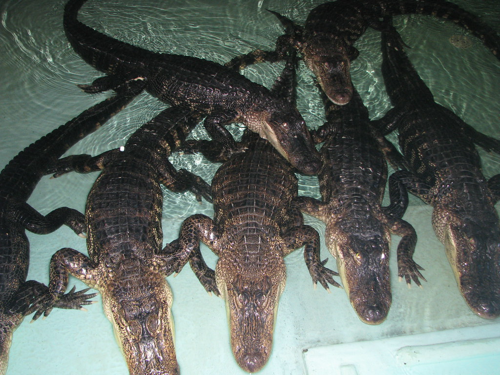
Down the road a bit in Louisiana, we stopped at the Insta-Gator Ranch & Hatchery near Abita Springs (map). I’d never been there before so that was a new experience. They raise alligators commercially and use their hides for handbags, wallets, boots, belts and other accessories. The State of Louisiana’s Department of Wildlife and Fisheries Alligator Program oversaw the entire operation.
“Since the inception of the Department’s program in 1972, over 810,000 wild alligators have been harvested, over 6.5 million alligator eggs have been collected, and over 3.5 million farm raised alligators have been sold bringing in millions of dollars of revenue to landowners, trappers and farmers.”
Alligators were an endangered species in Louisiana prior to the program. The population rebounded dramatically. Each commercial rancher continues to return a certain percentage of its adult alligators to the wild as a condition of the program. Four year old alligators are large enough to avoid predation so they have a very high survival rate, leading to more eggs and more alligators.
Alligators lay eggs only once per year and they hatch in late August-ish. Ranchers from Insta-Gator fly ultralight aircraft over the marshes and swamps to spot the nests, mark them with a flag, and return to collect eggs. Then they raise hatchlings to adulthood, some destined to become handbags and some destined for freedom. I’ll offer some advise for any alligators being raised commercially: get a nick or scar on your belly because that gives you an imperfection and you’ll probably be freed. Nobody wants a handbag with a blemish.
The ranch had several alligators much older and larger than the rest. They used those reptiles for movies, television and advertisements. It burst my bubble just a bit when I learned that many of those “reality” TV shows set in swamps and bayous use farm-raised gators. The scenes are staged!
Laurel & Hardy
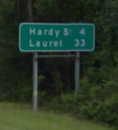
This one is a bit of a non sequitur. Does anyone remember back in 2013 when I featured intersecting streets that formed the names of Comedy Duos? Like, someone in Washington Radley, Kansas lives at the corner of Abbot & Costello? It’s not that important so don’t worry about it if you don’t.
Anyway, I spotted this road sign in Hattiesburg, Mississippi and didn’t have enough time to pull out my camera so I’ve borrowed a Google Street View image. It wasn’t quite a crossroads like in the earlier article. Laurel, in this case, was a nearby town. Hardy was one of the primary streets in Hattiesburg; it went directly past the University of Southern Mississippi. I still laughed a little when I saw the unintentional reference to Laurel & Hardy.
Leave a Reply