
I’m still in Boston and I found my way over to the Harvard Bridge across the Charles River, connecting the Back Bay of Boston to the Massachusetts Institute of Technology in Cambridge. Nobody calls it a particularly remarkable bridge as far as those things go, but it does offer amazing views when the weather cooperates.
Like when I visited.

I imagine it would be an entirely different scenario in the middle of winter when the winds howl and the snow blows across an ice-crusted river. On those days I’m sure its nearly half-mile length would seem as insurmountable as a trek up Denali with every step challenged. Nonetheless it seemed quite pleasant on a perfect autumn afternoon and certainly worth experiencing in person.
Looking for Something Else Though
However I didn’t go there to enjoy the view or stretch my legs or ponder its engineering legacy (although it does date back to 1891). Rather, I wanted to follow-up on one of my earlier articles in person. I felt a geo-weird compulsion to track down the historical birthplace of the elusive Smoot. Well, I’m not really all that obsessive-compulsive. I happened to be in the neighborhood. It was nearby and convenient. I didn’t really have to go out of my way either. Ahem. Right. That’s what one calls “rationalizing.” Anyway…
The Smoot, as you will recall from what I provided previously represents as an obscure unit of measurement. It stretches approximately five feet and seven inches (5.58333 feet / 1.70180 metres).

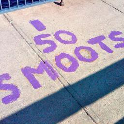
The Harvard Bridge, sometimes called the MIT Bridge or the Massachusetts Avenue Bridge, is marked in units of smoots on both sidewalks, starting at zero at the Back Bay and counting to 364.4 +/- one ear at MIT. Thus it’s a useful indicator for MIT students to inform them of the remaining distance to their campus.
It’s marked generally in units of ten. Various other special numbers are also given consideration in the markings. Many of the units in the 80’s and 90’s, for example, were obviously marked to commemorate graduating classes from recent decades. The halfway point is marked “Halfway to Hell” and things like that.
A reader may wonder wonder whether I actually crossed the bridge because my photo marks only 50 Smoots. That was due more to the lighting. Severe shadows from a setting sun obscured my photos of the final marker. I do admit that I thought about returning after 50 Smoots but I pressed on until the end. I’m glad I did because there is a plaque at the far northwestern corner.
The Commemoration

It’s tough to read from this image, so here is a transcription.
“In Commemoration of the 50th Anniversary of THE SMOOT. In October 1958 the span of this bridge was measured using the body of Oliver Reed Smoot, MIT ’62 and found to be 364.4 smoots +/- 1 ear. This provided a very useful metric for generations of bridge travelers since, and the smoot has joined the angstrom, meter, and light-year as enduring standards of length. Ollie’s contributions to measurement continued after his graduation from MIT. He went on to head both the American National Standards Institute and the International Organization for Standardization. Dedicated to our classmate, Oliver Reed Smoot ’62. October 4, 2008 by the MIT Class of 1962.”
I’ve enjoyed my stay in Boston but now it’s time to return home.
Leave a Reply