Smallest County in the USA, Epilogue

The previous entries discussed the whole issue of “smallest county in the United States” in way more detail that it probably deserved. However, I wanted to point out one more oddity. The smallest self-governing county and the smallest independent city share a common border!

Arlington County and the City of Falls Church in Virginia. Adaptation of a U.S. Census Tiger Map.
Arlington County and the City of Falls Church in Virginia

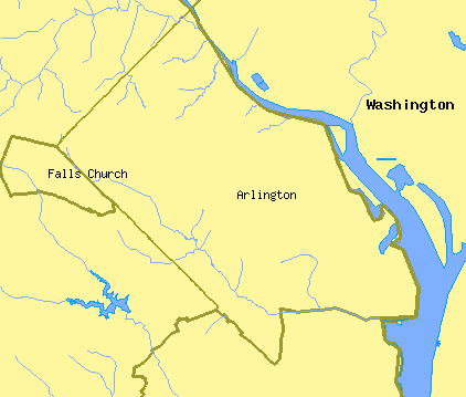
So Arlington’s far western border runs straight along the entirety of Falls Church’s eastern border. This line forms part of the original District of Columbia boundary described in the previous post.

Originally this point served as DC’s “west cornerstone.” Now it stands as the northernmost point that Arlington and Falls Church share. Additionally, to make that situation even more interesting, Fairfax County also joins at that point. Thus three distinct geographic entities touch at the stone.

Arlington County and the City of Falls Church in Virginia. Photo by howderfamily.com; (CC BY-NC-SA 2.0)

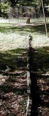
In this photograph, Falls Church is on the left side of the line and Arlington is on the right. Fairfax joins them at the stone enclosed within the cast iron fence in the distance. I discuss this location in more detail on my DC Boundary Stones page.


A quick final summary of posts in this series:

Comments

2 responses to “Smallest County in the USA, Epilogue”

  1. E.C. Avatar
    E.C.

    Love your site!

    Not sure if you’ve covered this but one question: it looks like the original DC/VA border cuts right through the street grid of Old Town Alexandria; that can’t be true, right? I have never seen any indication that the old port city was divided…

    1. Twelve Mile Circle Avatar

      It is true. Well, sort of… it does cut through the middle of Alexandria as it appears today. The Alexandria of old was considerably smaller and the intent was to place it within the boundaries of the original District of Columbia. After the 1847 retrocession — when the land returned from DC to Virginia to form Alexandria City and Alexandria County (now Arlington) — the city of Alexandria began to grow. Eventually they annexed land from Fairfax County which was not part of the original 10X10 mile square, which is why you see the original DC line cutting right through the city.

Leave a Reply

Your email address will not be published. Required fields are marked *

Latest Comments

  1. Technically it’s not always correct to say EST/CST, etc…. but just an indication that I’m changing time zone is enough,…

  2. In general, I wonder why navigating from the Atlantic Ocean to the Black Sea doesn’t count as inland navigation.

  3. Re: East/West Carroll parishes, you’re close, but the real reason for the split was more political than demographic or cultural.…