
Sometime examining something from a different angle provides interesting results. Other times it provides only the previous results, just with a different angle. Today it was the latter albeit with one unrelated twist at the end.
I thought about a 12MC article from 2010, New Highpoint for the Netherlands. It pointed out the interesting situation of Saba, which had just become an integral part of the Netherlands and thus the highest point of elevation for the nation. I wondered, and I continue to wonder about other countries where that some condition might be true. Maybe I could put together a list, or so I though, since I hadn’t seen anyone do that before.
I found several examples of the national highpoint physically removed from the predominant landmass of the nation. I’ll review the ones I found in order, from lowest elevation to highest, making the first one as already noted,
The Netherlands

Mount Scenery on Saba (map) is a classic stratovolcano with steeply rising slopes, in this case climbing to 887 metres (2,910 feet). Not to worry, it hasn’t erupted since the 1640’s so it probably won’t blow anytime soon. The elevation highpoint for the Netherlands could change dramatically if that ever happened.
South Korea

Volcanoes and islands, what a lovely combination. Halla-san on South Korea’s Jeju Island (map) is that nation’s highest point of elevation, at 1,950 m (6,398 ft), and continued the trend. It was a different type of volcano than Mount Scenery though, a shield volcano. Those tend to have a gentler slope formed by fluid lava. They are reminiscent of a shield that a giant soldier may have laid upon the ground.
Portugal
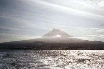
For Portugal, one must head to the mid-Atlantic and the Azores Archipelago, to the island of Pico (map). The Portuguese word “pico” means peak. So the whole island takes the name of the big mountain there, Montanha do Pico. It rises to 2,351 m (7,713 ft).
Another island, another volcano, and a stratovolcano here.
I’ve been there, and I took this photo while approaching the island by ferry. Well, not all the way to the peak of Pico. A road crosses the spine of the island and goes up to a pretty high elevation. It was quite chilly and windy so we didn’t even consider climbing to the highpoint.
Spain

Spain’s highpoint sits in the Canary Islands, on Tenerife, at Pico del Teide 3,718 m (12,198 ft) (map). This one provided a bonus, a shield volcano topped by a stratovolcano! It last erupted about a century ago and it will likely happen again in the not-too-distant future, and possibly quite violently. Spain’s highpoint will undoubtedly change.
United States

Whether one calls it Mount McKinley or Denali, the highpoint for the United States rises to 6,168 m (20,236 ft) (map), in the exclave of Alaska. Plate tectonics pushed rock upward to form the peak, however it is not a volcano. Thus, Denali is the exception to the rule, neither a volcano nor located on an island.
I’ve been to Denali, too! — well, within 40 miles of it. Can’t you tell from the photo I took? The dirty little secret that many visitors guides gloss over: clouds obscure the mountain at least two days out of every three. Guess which two days we visited?
Other possibilities
I didn’t do anything with Mawson Peak on Heard Island, which is an Australian external territory, or Mount Paget of South Georgia and the South Sandwich Islands, which is a British overseas territory. Potentially those could be added to the list depending on how one interprets those territories with respect their home nations.
Additionally I discarded highpoints for many of the island nations. They didn’t seem to meet the spirit of the list.
The One Thing I Learned
All of the locations I reviewed had been mentioned previously on 12MC, either in an article or in a reader comment, although I couldn’t know that until I’d finished my search. I considered today’s post as being somewhat akin to my occasional series of “greatest hits” articles.
However I stumbled across something interesting: the highest point of elevation for Antigua and Barbuda is Mount Obama. Indeed, it was named for U.S. President Barack Obama. That happened on August 4, 2009, his 48th birthday. The name change will probably draw more tourists than its previous designation, Boggy Peak.
I’m still not sure how that little fact slipped by 12MC unnoticed.
Leave a Reply