
A sawtooth may not exist in Rhode Island. Nonetheless, I found plenty of others sawtooths (sawteeth?) elsewhere throughout the English-speaking world. That provided a wonderful opportunity to continue on a theme. Additionally it offered a chance to choose advantageous locations. By that I meant I decided to fill empty spots on the Complete Index map by applying a few more push-pins.
Idaho
I didn’t offer much coverage in central Idaho. Specifically I targeted an area that coincided with — wait for it — the Sawtooth National Forest. That seemed amazingly appropriate. The government protected a massive space within the forest, more than two million acres. It dated back to the early days of the Federal portfolio, too. President Theodore Roosevelt himself designated it more than a century ago.
Sawtooth Range & Sawtooth City

The name derived from the Sawtooth Range, a part of the Rocky Mountains. Many peaks there jut over 10,000 feet (3,048 metres). The range got its name — well just look at it! — from its resemblance to the jagged teeth of a saw blade.
Near the mountains and within the forest stood the remains of an old town called Sawtooth City (map). It began like so many other settlements in this corner of Idaho as a mining camp in the latter part of the Nineteenth Century. Sawtooth City hugged Beaver Creek near a spot where it joined the Salmon River in a rugged and beautiful wilderness.
The town flourished for awhile in the 1880’s. Then miners moved on to the next big strike. Nature reclaimed much of Sawtooth City although its ruins became part of the National Register of Historic Places in the 1970’s, “the only visible remains are the mill foundations, one old log cabin and the crumbling remains of many other buildings.” What an ignoble ending to a settlement that once housed nearly six hundred residents.
Atlanta?
I noticed another town nearby, not named Sawtooth although something a little less obvious. Why did Idaho include an Atlanta (map)? It fell neither near the Atlantic Ocean nor near the city of the same name in Georgia.
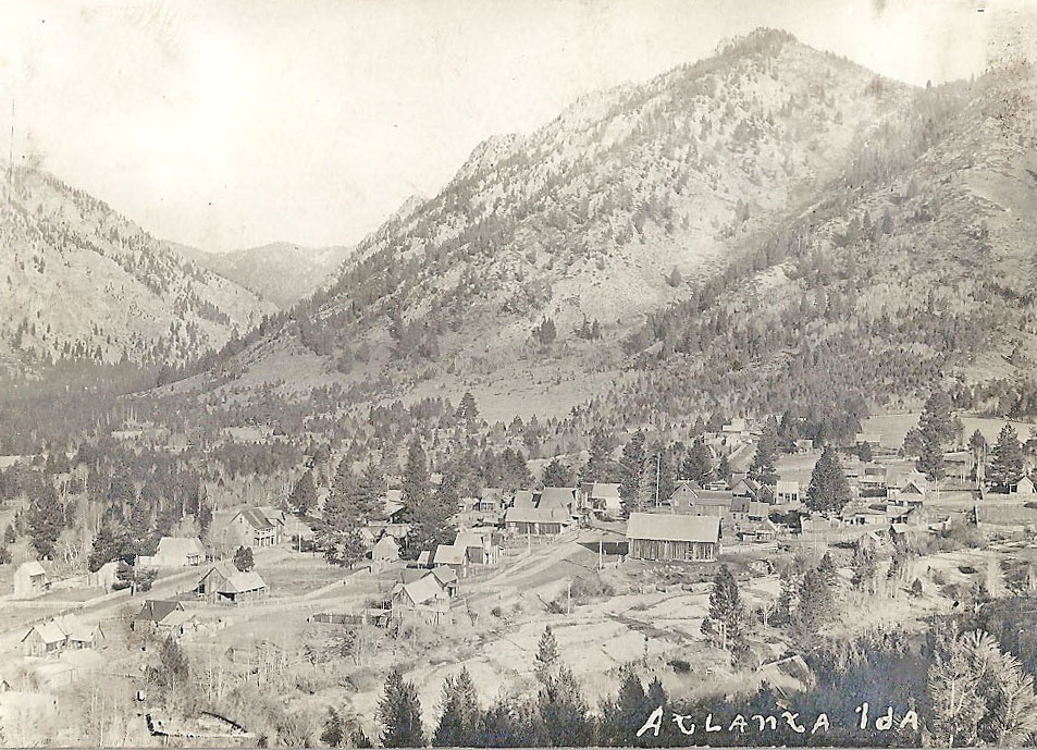
Atlanta originated earlier than Sawtooth City although for a similar purpose.
“Gold was discovered near Atlanta in 1863 and… there were Confederate sympathizers among the early miners. They eventually named Atlanta after the battle of Atlanta, which was fought in July of 1864 and, initially unbeknownst to the southern sympathizers, did not go well for the south… by the time they received clarification that the south had lost, they had already named the town and the name stayed the same.”
I couldn’t verify the truth or not although it sounded like a good story so I stuck with it.
This was a remote area. Even today the only way to reach Atlanta overland involves one of two unimproved US Forest Service roads. The site sit some 40 miles (64 km) from the nearest paved road. Nonetheless it remains a settlement, now bringing in tourist dollars thanks to its superb location for numerous outdoor activities in the Sawtooth Range, aptly described as a “sportsman’s paradise.”
Nunavut
.jpg)
Another rugged Sawtooth Range existed elsewhere, in the far northern reaches of Canada. The range crossed through the central part of the world’s tenth-largest island, Ellesmere. The mountains were a portion of the larger Arctic Cordillera range. Nunavut’s Sawtooth was so remote that few people ever got a chance to experience it firsthand. Fewer than a hundred and fifty people inhabit the island, living in its sole community Grise Fiord or at one of its two tiny High Arctic Weather Stations.
Scientists built one of those two stations in proximity to the Sawtooth Range (map). It became Eureka when established in 1947 by Canada and the United States working together.
“Although much of the land was rough, rising to 2,000 or 3,000 feet, the most satisfactory location appeared to be in Slidre Fiord on Ellesmere Island, centrally located at latitude 80 00′ 00″ N., longitude 85 56’25″W. Within the fiord, the ice was quite smooth. Protected by hills from the prevailing north westerly winds, it is surrounded by low rolling country and is in the vicinity of two rivers, which promise fresh water in summer.”
Only about ten people staff the station throughout the long winter, in the coldest place in Canada. While many other Canadian locations have recorded lower absolute temperatures, Eureka took the prize for the lowest average yearlong temperature, a bone-chilling -19.7C (-3.5F).
Leave a Reply