
Google Maps released a huge set of Street View images for the United Kingdom a few days ago as you’ve undoubtedly learned on all of the geo-blogs by now. This extends the level of coverage for England, Scotland, Wales and Northern Ireland to upwards of 95% of the road infrastructure. I’m sure you’ve had an enjoyable time searching through familiar places, and I have done the same.
Have any of our UK readers found their homes, businesses and local landmarks yet? That’s the first thing I did when Street View first arrived in my little corner of the world in November 2008. Any surprises? Were any of you lucky enough to be standing outside when the Street View car made its panoramic sweep?
Let’s Throw A Dart
This event handed me an excellent opportunity to play the Throw the Dart game. That’s where I wiggle the cursor around haphazardly, let it drop onto a Street View randomly, and see if I can write an article. I tried it once before in October 2009 and it seemed to work for Piedmont, Alabama. But can I replicate my recent success? We’re about to find out.
This isn’t so bad. At least it’s in an urban area instead of the middle of a farmer’s field. Barker Lane, Chesterfield, Derbyshire, England. It looks like a pleasant enough little side street with some older red brick buildings. Let’s take a walk vicariously down Barker Lane towards the crossroad and see what we can discover. The street dead ahead is Chatsworth Road. Maybe that will provide some clues as I attempt to orient myself.
What’s This?
There seems to be a little commotion at the end of the block. Let’s check it out. I’ll take a screen grab so that future generations won’t wonder what I’m talking about when the Google car returns and updates the image. I’ve learned that lesson the hard way.
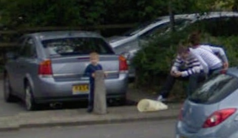
It seemed like something odd was happening from some of the angles but it turns out to be rather mundane now that I’ve found a clear shot. The couple appears to be hunched over the screen of their mobile phone while their child stands behind their car. Yawn.
Better Luck At the Brewery
Well that was a complete waste of time. I did notice, however, that the pub at the northeast corner of Barker Lane and Chatsworth Road has a sign advertising Real Ales. I love high quality ales and I’ve visited more than 240 breweries and brewpubs during my travels. Nothing would make me happier than stopping for a pint or two. Too bad I can’t reach through the screen.
Maybe the search engines will be kinder to me. One of the early hits doesn’t look too promising upon first glance: “CHESTERFIELD has never been renowned as a vibrant centre of social sophistication,” according to the Sheffield Telegraph [article no longer available online]. That could make my explorations troublesome. It improves, however:
“– but that could be about to change. Until now Brampton, on its western edge, has been best known for a pottery, a brewery and a mile-long stretch which once boasted a head-spinning 22 pubs… Change has crept in gradually on Chatsworth Road.”
Brewery? Did someone say brewery? Things are definitely looking up. The article is probably referencing a large commercial brewery that existed in Brampton for most of the Nineteenth Century and about halfway into the Twentieth Century. Nonetheless, travel only two-tenths of a mile from my randomly chosen spot on Barker Lane and arrive at the Chatsworth Business Park.
A new incarnation of the Brampton Brewery resides here, a microbrewery focusing on high quality cask-conditioned and bottled ales. There seem to be several other beer-related happenings in the area as well. Chesterfield hosted the world’s first Gluten Free Beer Festival in 2006. It’s also the home of an active chapter of the Campaign for Real Ales, or CAMRA. Brew on, Chesterfield!
Aspire To Spire
There’s one other site about a mile and a half from our random selection that I don’t want to miss. Yes, here it is:
This is the crooked spire of the The Parish Church of St. Mary and All Saints, and a symbol for Chesterfield itself. It even inspired a nickname for the local football club, The Spireites. This whimsical spire not only twists 45 degrees but it leans about ten inches off of true centre. The twisting was intentional but the leaning probably resulted from craftsmen error back in the Fourteenth Century when they constructed it. Several other theories have been offered — some serious, some fanciful — but you can check those on your own at its Wikipedia page. Yes, I’m convinced, everything has its own Wikipedia page.
I think this random choice went reasonably well even though it started slowly. Once again this proves that every place has a story and it’s only a matter of digging hard enough. Next I think I’ll go back through my previous articles with UK content and see if I can find Street View images for them.
Leave a Reply