
I found one surprising benefit to the tedious research that went into the recent Last Presidential Counties article. Now I could sort through the data differently and come up with several unexpected yet equally fascinating facts. It produced enough material for a second article. But don’t think of these as leftovers! They stand on their own.
Early Achievers

I thought that most counties names arose in fairly close proximity to a president’s term in office. Generally that proved true. However I began to see that a noticeable number did not. They got their names before their namesakes ever served a day as president. That began to make sense as I thought about it a little more and began checking individual county histories.
Consider that anyone who had the ability to became president of a nation — any nation — must have possessed extreme ambitions. These people didn’t simply drop out of the sky. They didn’t land in the Oval Office without any effort on their parts.
The United States wasn’t a kingdom and nobody inherited the position. No, these people were all governors or legislators or generals or diplomats. They all filled prestigious positions, oftentimes multiple positions. Their efforts sometimes rose to a level of prominence that compelled states to name counties in their honor long before they ever served as president.
Harrison
William Henry Harrison became the earliest achiever. Indiana formed Harrison County in his honor a full 33 years before his presidential administration began. He’d already been a delegate to Congress representing the Northwest Territory before Andrew Jackson appointed him to become the first Governor of the the Indiana Territory in 1800. The territory was huge, encompassing all of current Indiana, Illinois, Michigan, Wisconsin and part of Minnesota. Indiana established Harrison County in 1808 including land that Harrison owned. It also established its capital there in the town of Corydon (map) where it would remain until moving to Indianapolis in the 1820’s.
Harrison subsequently reinvented himself as a military leader and moved to Ohio. Then he defeated Native American forces led by the Shawnee leader Tecumseh at the Battle of Tippecanoe in 1811. Next he defeated British forces at the Battle of the Thames in the War of 1812. That prompted Ohio to establish a Harrison County in 1813, some 28 years before Harrison became president.
He served in Congress representing Ohio and then as a diplomat before retiring somewhere around 1829. Harrison had already experienced enough adventure for several careers by that point. But then he ran for president in 1836 (he lost) and again in 1840 (he won). Finally he caught pneumonia and died after serving in office for only about a month. He probably should have quit while he was ahead.
Jackson
Andrew Jackson tied for second place. Tennessee created Jackson County in his honor 28 years before he became president.
Staying Power
Some presidents became greater icons than others. Many of the presidents who led the struggle for independence still had counties named for them several decades after they left public office. It should come as no surprise that John Adams and George Washington fared particularly well. They had counties named for them 110 years after they served: Adams County, Idaho and Washington County, Oklahoma.
Adams

There wasn’t much to say about Adams County, Idaho. It sat in a rural part of the state with fewer than four thousand residents. However, it did serve as the home of the increasingly rare Northern Idaho Ground Squirrel (Urocitellus brunneus brunneus)
“Very small range in west-central Idaho; declined from about 5000+ individuals in 1985 to only 450-500 individuals in 23 sub-populations in 2002; most (20) subpopulations comprise fewer than 50 individuals. Threatened by habitat loss and fragmentation as a result of forest encroachment into meadows, agricultural conversion, road construction, and residential and golf course development, and also by competition with Columbian ground squirrel and some shooting.”
It also offered a home to Brundage Mountain ski resort (map) in the Payette National Forest.
Washington
Washington County, Oklahoma with its county seat at Bartlesville was considerably better known. Washington was a funny little county; long and skinny. It was also the smallest in the state with only 424 square miles (1,098 square kilometres) of territory.
While Bartlesville wasn’t the largest city in Oklahoma — it had only about 35,000 residents — it played an oversized role in the oil and gas industry. So that was quite important to the state and its economy. The Phillips Petroleum Company formed there in 1905. It later merged with Conoco to become ConocoPhillips and then split to become Phillips 66 and ConocoPhillips in 2012. Both companies continue to retain a major presence in Bartlesville although now headquartered elsewhere.
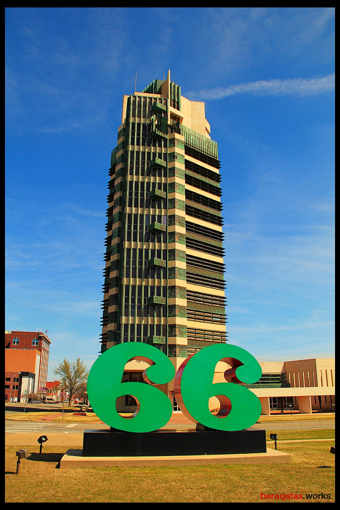
Bartlesville was also notable for Price Tower (map), now known as the Price Tower Arts Center. Famed architect Frank Lloyd Wright designed the building, one of only two he created in a vertical alignment.
“In Wright’s design for a tower, he combined cantilevered floors with what is called “taproot” design. Borrowing from nature, Wright understood that a building’s floors and outer walls could be held aloft in the same way that a tree raises it branches and leaves – with a trunk-anchored in place by a deep, central foundation, or ‘taproot’. The tower’s trunk consists of an inner concrete and steel core – actually four of them – that also serve as the elevator shafts. Cantilevered out from this central core are the tower’s 19 floors.”
Jefferson Too
Thomas Jefferson also had two counties named for him more than a century after he left office. Those were Jefferson County, Oregon (105 years later) and Jefferson County, Idaho (104 years later). Jefferson deserved special mention for two counties nearly at the top even if he trailed Adams and Washington.
However, it’s unlikely that other presidents will join the century list. Well, unless the United States colonizes the moon or Mars or something. Even so, there probably won’t ever be a Nixon County.
Most Presidential State
I continued to sort and noticed that some states had more counties named for presidents than others. Nebraska took top honors with twelve presidential counties: Adams, Arthur, Fillmore, Garfield, Grant, Hayes, Jefferson Lincoln, Madison, Pierce, Polk, and Washington. Iowa came in a close second with eleven and Arkansas followed just below with ten.
Leave a Reply