
I returned recently from another one of my hurried trips, this one to the New England states. All of them. Plus New York for good measure. Those of you who followed Twelve Mile Circle’s Twitter account knew that already. The rest of the 12MC audience may not have noticed anything at all. I wrote a bunch of articles in advance and they posted automatically, quite happily, as I cruised backcountry roads for a week.
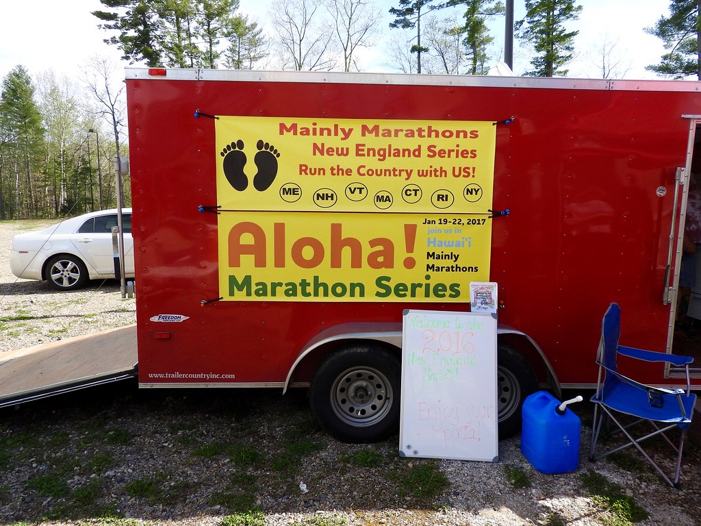
Once again, I chauffeured my favorite runner through small town America as part of a Mainly Marathons event, this time the New England Series. This group catered specifically to people hoping to run marathons or half-marathons in all 50 U.S. States (my favorite runner focuses on half-marathons), stringing together back-to-back races.
The 2016 New England series stopped at Sanford, Maine; Greenfield, New Hampshire; Springfield, Vermont; Northfield, Massachusetts; Coventry, Rhode Island; Simsbury, Connecticut; and New Paltz, New York, on succeeding days, May 15-21. A race happened each morning at dawn, then the circus packed up and moved on to the next state. Then the cycle repeated itself.
So that made a total of seven races in seven states in seven days.
Mainly Veterans
This was the fourth time I’ve attended a Mainly Marathons series, with my runner completing the Dust Bowl, Riverboat and Center of the Nation series previously. That was a lot of states. With New England now done, I’ve attended their races in obscure corners of 23 different states. Recently the Mainly Marathons group added a five kilometre option mostly for those of us who attended along with the longer-distance runners. I actually ran the 5K each day mostly so I wouldn’t stand next to the snack table for a couple of hours and stuff myself silly. I don’t have any intention of moving up to the half-marathon or marathon distances though. 5K each day was plenty enough for me.
We made time, as usual, for touring during the afternoon as we traveled between races. I’ll get into all of the details in the next batch of articles. I thought I’d start things off more scattershot with a few signs I noticed along the way. I’ve had a thing for unusual signs and this trip was no different. Ordinarily I’d present these at the end of a series although I thought I’d use them to whet the 12MC appetite. Think of today as an appetizer.
Welcome to Vermont

Surprisingly, I stopped at only one state border sign to record my crossing. This one occurred on U.S. Route 5 / Vermont Route 11 just after we passed the Connecticut River, as we left New Hampshire (map). This photo was particularly notable for my lack of skills as I managed to capture the top of the side-view mirror at the bottom of the image. That happened because I was too lazy to get out of the car when we stopped, and too incompetent to hold a camera high enough to get a decent picture.
That was also the only photo I took of the car, now as I consider it, although I probably should have taken more. We rented a compact car because it was just the two of us. We figured it would be fine and we’d save some gas money. The rental agency must have given away all of the compacts on the lot though, because we ended up with a black, two-door Ford Mustang with only 500 miles on the odometer. We cruised around New England for a week in that sweet ride.
Think of the Children!

I still wasn’t sure why the Toonerville Trail in Springfield, Vermont (map) felt it was necessary to ask us politely with a please and a thank you and all that, to think about our children in ALL CAPS. So, as the sign requested, I thought about the children. Unfortunately my only thought was a sign invoking the grossly over-worn and pandering expression “Think of the Children.”
School Bus?

While fixated on thinking of the children, or so I thought, I began to notice strange minivan school buses in multiple New England states. I’d never seen anything like them before. Were they used by private schools with far-flung pupils? Or for select children in special programs? I could definitely consider a role for these non-bus buses, and wondered if this was a common solution in New England (or elsewhere) or if I’d focused on them simply because they were unusual. I spotted this example on Interstate 91 near Deerfield, Massachusetts (map).
Also, before anyone becomes too concerned with my driving skills and posts a disapproving comment, let it be known that my passenger took this photograph. I kept both hands on the wheel and maintained a safe distance.
Marginal Way

I’ve often featured street names on 12MC, the more unusual the better. Generally I’ve only observed them on a map. That’s why I was so pleased to find Marginal Way in Sanford, Maine in the wild (map). It was right on the race course! Runners actually plodded directly down Marginal Way. I wondered about the name. How should a homeowner feel about property considered marginal? Would it affect its resale value? It ran along the edge — maybe the margin? — of a nearby pond. Was that how it earned its weird designation?
Don’t Jump!

This was an instance where I thought a sign might be overkill. Certainly people have jumped from bridges, although generally very high ones and often quite tragically. That wouldn’t be the case here at the Henniker Bridge in Henniker, New Hampshire (map), only a few feet above the water. This was a covered bridge of recent vintage constructed as a pedestrian pathway over the Contoocook River. It served as a footpath between the main campus of New England College and various athletic fields.
College students do seem to get into all kinds of antics. Maybe the sign served a purpose after all.
Road Trip

The driving force, the entire premise of this series, were races held in different states. Minimizing travel distances ranked higher in important than sightseeing for most participants. As a result, races generally fell within rural, out-of-the-way places near state borders. Sometimes this took us onto America’s Byways, for example the beautiful Connecticut River Byway extending through several states including this spot in Northfield, Massachusetts (map). We ended up putting a little over 2,000 miles (3,200 km) on that Mustang, many of them on winding country roads through quiet rural scenery.
New England articles
- Give me a Sign
- Of Course Geo-oddities
- Did I Mention Doughnuts?
- A Little History Too
- Yes, More Bridges
- Roundup
See Also: The Complete Photo Album on Flickr
Leave a Reply