Most Landlocked State

The query simply said, “Most Landlocked State.” It seemed innocent enough as I pondered it. I believed it would have a simple solution. However, the more I considered it the more I figured the answer could vary based upon one’s definition of landlocked. I wish I could ask the anonymous searcher what he (or she) meant but that’s not possible. I’ll throw out a few alternatives and let the Intertubes decide.

At a fundamental level, does he mean “state” as in an independent nation or as part of a larger entity such as one of the fifty United States? If it’s nation then I’d propose Uzbekistan and Liechtenstein. They are both Doubly Landlocked, meaning they are landlocked nations completely surrounded by other landlocked nations. Thus, Uzbekistan and Liechtenstein are probably as good a choice as any.


In the United States

bales.  Photo by David DeHetre; (CC BY 2.0)

However I’m going to examine the other alternative in a bit more detail by bringing the discussion to the United States. I’m also considering the possibility that states bordering the Great Lakes aren’t truly landlocked: massive ships can navigate a full 2,300 miles (3,700 km) from the Atlantic Ocean to Duluth, Minnesota. Some of the 12MC audience may disagree with that premise and that’s fine. I’m going to run with it.

Given that assumption, there are two U.S. states that are double landlocked: Kansas and Nebraska. Perhaps those are the most landlocked states?

Borderlocking

I defined a concept I termed “borderlocking” in an article I posted nearly two years ago: Layers of Borderlocking. It was a similar exercise although I focused my efforts at one level below the states, down at the county level. This created a rather colorful map with seventeen layers of borderlocking. Feel free to go back to the original article if you’d like a better description of what you’re seeing below.

Level of County Landlocking in the United States. Map produced by howderfamily.com; (CC BY-NC-SA 2.0)

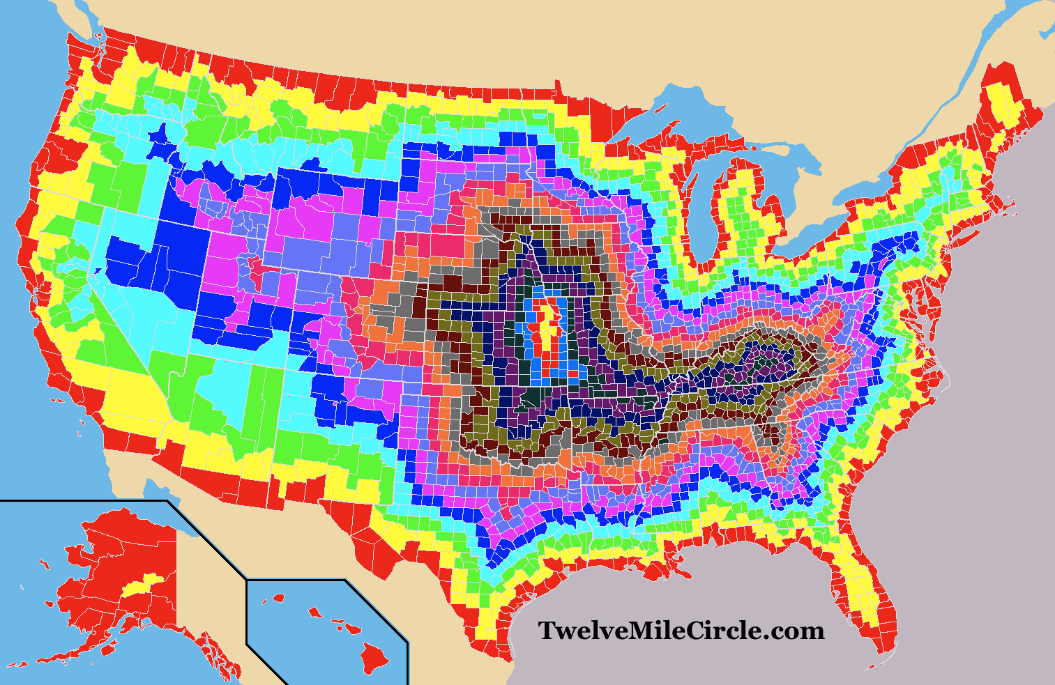
The full seventeen layers happens in a handful of counties in Kansas and in a single county in Nebraska. Interesting. That method also seems to favor Kansas and Nebraska as the most landlocked states, although with a slight nod to Kansas.


Coastlines

One might also consider the point of land within the United States that’s the farthest away from a coastline. That pole of inaccessibility, not only for the USA but for the entirety of North America, falls in southwest South Dakota. One would have to travel 1,030 miles (1,650 km) to reach the nearest coastline from that point.

Now that seems truly landlocked! So is the answer South Dakota?


Another Alternative?

I considered one other possibility. I already allowed an exception for Great Lake states because they’re water accessible. What if I took that concept one step further and defined landlocked as only those places where water could not escape to an ocean (eventually)? Which state has the most acreage within endorheic watersheds?

Kmusser [CC BY-SA 3.0 (https://creativecommons.org/licenses/by-sa/3.0)], via Wikimedia Commons

The Great Basin would be an obvious choice to investigate further. It covers most of Nevada and much of Utah, plus portions of several other states although to considerably lesser degrees. Water falls into the Basin but it doesn’t flow outward, leading to amazing oddities such as the Bonneville Salt Flats that I was lucky enough to visit last summer.

I’d propose Kansas, Nebraska, South Dakota and Nevada as feasible options for the most landlocked state, but I still don’t feel completely comfortable with any of those answers. Are there other ways we can consider this phenomenon and help out our anonymous reader?


Posted

in

, ,

by

Comments

17 responses to “Most Landlocked State”

  1. Peter Avatar

    Inland waterways complicate the issue. They may not be suitable for oceangoing ships, but the Mississippi/Ohio/Tennessee/Arkansas river systems, among others, carry massive amounts of barge traffic. If inland waterways count, neither Nebraska nor Kansas is double-landlocked. Nebraska borders Iowa and Missouri, which have river ports on the Mississippi. Kansas borders Missouri and also borders Oklahoma, which has inland ports on the Arkansas River (Tulsa’s port is surprisingly large).

    The Missouri River is navigable by barges as far north as South Dakota, but IINM it no longer carries any commercial shipping.

    1. Twelve Mile Circle Avatar

      I completely agree, Peter. Introducing an inland waterway (the Great Lakes) creates a whole host of other considerations such as the ones you mentioned. It’s something I went back-and-forth with as I developed it. I may have to recreate this map someday (might be a fun exercise).

  2. dieta Avatar
    dieta

    Western forces in landlocked Afghanistan rely on the winding, mountainous road for delivery of up to 75 percent of their fuel, food and other goods, which arrive in Pakistan via the port city of Karachi.

  3. Matt Avatar
    Matt

    Great stuff!
    How did you get the 17 layers and the colored map? Manually? Or have you developed a fancy PostGIS SQL Select statement? Or did you use a desktop GIS? I’m very interested.

    Greetings from Germany

    1. Twelve Mile Circle Avatar

      Manually. Sometimes brute force is the simplest solution for a one-time project. This map took maybe all of fifteen minutes… can’t imagine how long it would have taken using a more sophisticated approach.

  4. The Basement Geographer Avatar

    I can’t help but think that if I were to do something like this for Canada, the most borderlocked piece of land would still be within 400 miles of the US border. I may have to work on this…

      1. Twelve Mile Circle Avatar

        Sweet. I hope everyone follows the link and checks it out. It’s a great result.

  5. Snabelabe Avatar
    Snabelabe

    I did the same for Belgium, at municipality level. And there are 9 levels of borderlocking, with the municipalities of Forest, Oudergem, Sint-Pieters-Woluwe and Overijse in the ninth level. All these are very close to Brussels. Here is the map: http://farm8.staticflickr.com/7159/6441490133_a551bd99ae_b.jpg

    1. Twelve Mile Circle Avatar

      I know someone who lives in Overijse! — Of course, he has no interest in geo-oddities so I don’t think he’ll care much (but I still think it’s cool). 🙂

  6. Pfly Avatar
    Pfly

    Argh, after seeing this and Basement Geographer’s Canadian version I had to do one combining Canada and the US. Took some time, but here it is:

    http://pfly.net/pfly/USCAborderlocked.png

    Note that the data I used is at least ten years old and might be out of date in places (and I likely made a mistake or two here and there). For Canada I tried to follow Basement Geographer’s system of “county equivalents” (sometimes regional districts, sometimes municipalities, etc), but my data did not exactly match in some places. And then there are issues of when exactly two counties are touching. I didn’t count corner touches and also didn’t spent extra time determining exactly where an apparent corner-touch might actually be a very small segment. So, “results may vary”. Also, I wanted to include Mexico, but when I looked into 2nd level subdivisions (municipalities) I found they were often *very* small–plus I didn’t have a dataset of them. So I made due just using Mexican states.

    With all those caveats, the results are: Three counties in Nebraska, on the border with Kansas, came out as the most locked–21 counties from the sea (or Great Lakes). Those counties are Jefferson, Thayer, and Nuckolls, Nebraska. There’s an “island” of fairly locked Canadian county-equivalents in southern Saskatchewan. Two “rural municpalities” being the most “locked”, at 15 counties from the sea (or Great Lakes). I had some trouble identifying them, but I think they are Rural Municipality (RM) 69, “Norton” (offices in Pangman, Sask.) and RM 132, Hillsborough (offices in Moose Jaw).

    1. The Basement Geographer Avatar

      This is just amazing, Pfly; I love it when people take stuff like this to the next level. It’s actually got me thinking about the ultimate task: tackling the 36,781 communes of France (I’m sure my hard drive shudders at the thought).

  7. SWL Avatar
    SWL

    i think it is nebraska from a strictly logical level. just highly nebraska white and all the states that border it red. Then all the states that border it blue. then all the states that border it, say, purple. you will find nebraska the most landlocked state at a strictly logical level in terms of states. at an international level? you are on your own. But Nebraska wins, hands down. it is literally The Middle of Nowhere. it deserves that honor. Go NEBRASKA!!! (I am fron Connecticut, by the way!!!)

  8. Christa Avatar
    Christa

    Nevada

  9. HAW Avatar
    HAW

    Nebraska, because it is triply landlocked. It is in the middle, and Kansas is further south, closer to an ocean, the Gulf of Mexico.

  10. Peter Avatar
    Peter

    How would only KS and NE be doubly-landlocked? What about WY, CO, and UT?

Leave a Reply

Your email address will not be published. Required fields are marked *

Latest Comments

  1. Many of these comments are very interesting, have enjoyed reading. We cross several times a year as well going from…