
I tagged along while my wife attended a work-related conference in West Virginia’s eastern panhandle. The in-laws watched the kids back home. That provided me with a rare couple of days to wander around the woods while my wife schmoozed with conference attendees. The area was amazingly rich in significant events that shaped a nation. John Brown’s final stand took place at Harpers Ferry. The Battle of Antietam happened just across the river in Maryland. With my background as a historian, what was my focus for my initial day? The Maryland-Virginia-West Virginia (MDVAWV) tripoint, of course.
I can defend my decision. I grew up a couple of ridges over on the Virginia side of the border. So I’ve walked through these iconic historical sights dozens of times. Often I’ve even acted as an informal tour guide for family and friends. I wanted to focus instead — just this one time — on the geographic features of this tripoint area at the confluence of the Potomac and Shenandoah Rivers.
To the Tripoint
Most readers have followed Twelve Mile Circle long enough to know that I’m all about the easy catch. I’m compelled to visit these places but I’m also lazy, and I feel no shame admitting that. Thus, while it’s theoretically possible to touch the actual MDVAWV tripoint — and many people have done that — I felt no particularly burning desire to replicate it. It required a walk down a heavily-traveled and dangerous highway with narrow shoulders for several hundred yards. Then I’d have to hop a guardrail, and shimmy down a steep muddy bank to the riverside. No thanks.
I considered it “good enough” to circle around the tripoint in all directions within reasonable proximity. I realize this is anathema to real tripointers. They feel a need to place their foot on the actual physical spot for it to count. So be it. If you’re unruffled by my lack of complete geo-geek compulsive accuracy, then please feel free to continue reading.
The Drive
MDVAWV is one of those areas where one can easily travel through three states in a matter of moments. In this instance it’s a brief trek along U.S. Route 340. The video starts in Maryland at the end of a bridge since Maryland “owns” the entirety of the Potomac River. This is a condition that traces all the way back to a 1632 Royal Charter. The preponderance of the clip then traverses Virginia territory. Finally, near the very end of the video, the Jefferson County, West Virginia sign appears.
One should be able to complete the journey in under a minute during normal conditions. I would have accomplished that had I not been delayed by traffic at the stoplight. Somehow Virginia managed to cram an intersection, traffic light and gas station into their tiny section of Route 340.
This is one of my favorite geo-oddities of all time. I have memories of this tri-state combo going all the way back to my childhood.
Over to West Virginia
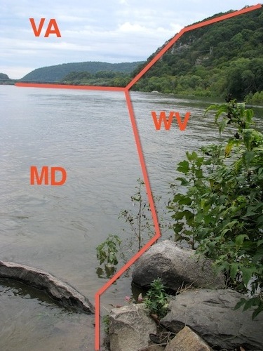
I crossed a river again, this time the Shenandoah, on the way to Harpers Ferry National Historical Park. The confluence of the Shenandoah flowing into the Potomac would be a great place to locate a town during a time when water served as a means of transportation. It also provided plenty of industrial muscle. History runs deep in Harpers Ferry and maybe I’ll save some of that for a future post. However, today I walked directly through the lower town and focused solely on the tripoint.
This vantage begins at the furthest tip where the Shenandoah and Potomac join, focused downstream. I guess the most interesting feature here is the section of West Virginia on the other side of the water. That is the northernmost corner of the only section of the state that can be considered “Almost Heaven” legitimately. The rest of West Virginia shouldn’t be allowed to sing that annoying song about country roads. Nonetheless it’s completely acceptable in that small, narrow strip. I refrained from singing. That would be painful for anyone standing nearby. I did hum to myself quietly.
Maryland Heights
A pedestrian walkway along a railroad trestle extends from the base of Harpers Ferry to the Maryland side of the Potomac River. It provides access to the Chesapeake and Ohio Canal National Historic Park. The C&O Canal towpath stretches along the Potomac from Georgetown in the District of Columbia to Cumberland, Maryland. That’s 184.5 miles (297 kilometres). I hiked only about a half-mile of that distance until reaching the Maryland Heights trailhead.
The climb up the bluff is quite invigorating. It also passes remnants of Civil War batteries that converted Maryland Heights into a mountaintop fortress. If I’d had more time that morning I would have completed the five-mile loop along the ridge. Then I could have wandered through some even more impressive ruins. Instead I took the spur towards an overlook high above Harpers Ferry on the Maryland side. The vantage provided views of the town and of course the MDVAWP tripoint area.
This was a wonderful spot to stop for a quiet, contemplative lunch. I had the high ground all to myself.
Leave a Reply