
The setup might take a little explanation. I wanted to find the lowest county highpoint in each of the fifty United States. There would only be one per state based upon a series of lists provided by Peakbagger.com.
That might lead to speculation that a better solution would involve examining all county highpoints regardless of state and rank them accordingly. I’d consider that fair criticism and maybe I’ll draft a Part 2 where I do that someday. However, just for today, I found it a lot easier to deal with a sample of 50 data points rather than 3,142 because I had to transcribe everything by hand. That was the real explanation.
I’ve shared the resulting Google spreadsheet with the 12MC audience, featuring one single lowest county highpoint per state. Can you guess which states had the lowest county highpoints? I knew most of them although the order surprised me.
Virginia
Virginia provided the overall lowest county highpoint with the independent city of Poquoson (map), which was considered a “county equivalent” for census and other statistical purposes. Poquoson’s peak elevation hit only 10 feet (3 metres) in several different places, just a storm surge away from complete nonexistence.
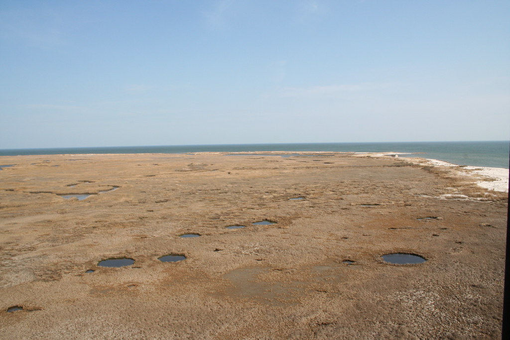
It certainly seemed flat enough judging by the image published by U.S. Army Corps of Engineers from Plum Tree Island. Those holes might be bomb craters by the way. The Corps explained that Plum Tree served as a bombing and artillery range before it became a wildlife refuge.
I agree, a “county equivalent” with only 15 square miles (40 square kilometres) of dry land felt like cheating. Virginia and its wacky independent cities always seemed to throw a monkey wrench into county comparisons. Looking solely at Virginia COUNTIES, the lowest highpoint would be Accomack on the eastern shore with a summit of 60 ft. (18 m.). That exalted elevation would knock Virginia several notches down the list.
Louisiana

No state suffered more from my arbitrary set of rules than Louisiana. I don’t think any other state had anywhere near the sheer number of low-elevation counties than Louisiana, where of course they were called parishes. I counted 25 parishes with a peak elevation of 100 ft. (30 m.) or less, including 7 parishes at 20 ft. (6 m.) or less. Louisiana’s issues with erosion were well understood. The southern end of the state continues to wash into the Gulf of Mexico as each big storm passes.
Terrebonne Parish climbed to only 13 ft. (4 m.), and barely resembled dry land at all with its endemic pockmarks clawed by hurricanes (map). Jefferson Parish, a west bank and east bank suburb of New Orleans, ranked a close second at 15 ft. (5 m.). One of my family members lived in Jefferson Parish during Hurricane Katrina and the elevation was just high enough to keep their house from flooding.
North Carolina
Conventional wisdom led me to believe that the lowest county highpoint of North Carolina would be found on the sandy barrier islands and ridges of the Outer Banks. That would be wrong. I should have remembered that the Wright Brothers chose Kill Devil Hill on the Outer Banks for gliding experiments prior to the first airplane flight precisely because it was a hill.
The actual lowest county highpoint triangulated to a spot on the mainland nearby in Tyrrell County, a place without sand dunes (map). Tyrrell’s highest summit hit 17 ft. (5 m.).
Other Notable Highpoints

I’ll mention a few more locations briefly.
Perhaps I could be excused for thinking Monroe County, Florida — the county of the Florida Keys — would have been the winner. It wasn’t. Monroe County had a highpoint on Lignumvitae Key at 19 ft. (6 m.), the site of Lignumvitae Key Botanical State Park. It wasn’t accessible by road so maybe that’s why I never noticed it during my many drives along the Keys (map).
Much farther down the list, New York featured Battle Hill (map) as its lowest county highpoint. That was in Kings County, a place known better as Brooklyn. It led me to wonder about the namesake battle of said hill.
Fighting took place on the hill at the site of the current Green-Wood Cemetery during an early phase of American Revolutionary War, August 1776, a part of the larger Battle of Long Island. American forces inflicted heavy losses on British troops who attempted and failed to capture the hill. Shortly thereafter, George Washington evacuated all of his troops from New York City anyway because he was badly outmatched.
A final nod should go to Utah with the highest of lowest county highpoints. That was a rather impressive 9,255 ft. (2,821 m.) at Rich County’s Bridger Peak (map).
Completely Different Topic: Welcome Manaus!
Twelve Mile Circle seems to have attracted a regular reader from Manaus, in the Amazonas state of Brazil. I first noticed the anomaly during the World Cup when the United States played in Manuas and I figured it was an US reader who traveled down for the game (even mentioned it on the 12MC Twitter). However I continue to notice hits from Manaus at a regular pace. This counts as my official welcome. Thank you for coming to the site!
Leave a Reply