
I thought I would combine elements of several different articles to create something new. Counter-intuitive distances have long been a theme on 12MC. Great examples include Los Angeles located farther east than Reno and Glasgow located farther west than Madrid. Then I stirred-in an online tool used to create circles of user-specified radii on Google Maps. As a final layer, I looked at lines of maximal length across the continental United States, including the ultralineamentum.
Start With the Ultralineamentum
Dr. Cliff Pickover coined the term ultralineamentum (“The line could not pass outside America and could not go through the oceans and the Gulf of Mexico. In other words, the line had to stay inside the continental boundaries“). The actual calculation came from Mark Nandor who determined it ran from Neah Bay, Washington to Jupiter, Florida, a distance of 2,802 miles (4,509 kilometres). I’ve marked it as a blue line on the embedded map, above. If you drill in further on the map near Florida the line will appear to cross over a corner of the Gulf of Mexico. This is actually an inaccuracy inherent in Google Maps and the way it attempts to deal with the curvature of the earth.
Mr. Nandor also calculated the absolute longest line, which, unlike the ultralineamentum, does cross national boundaries. I marked that one as a red line. So it stretches 2,892 miles (4,654 km.) which isn’t all that much longer than the ultralineamentum. Notice that it crosses over a segment of Canada as it traverses the Great Lakes region on its journey between Point Arena, California and West Quoddy, Maine.
Then Apply the Circles
Now it was time to draw some circles starting with the ultralineamentum end-points.
Neah Bay
I started with Neah Bay and specified a radius 2,802 miles.
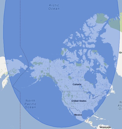
It certainly doesn’t look like a circle. Than again, a round earth creates distortion when flattened. Also, don’t bother to click on it because it’s a screen-grab. Google Maps doesn’t support the format natively. The more important point is that Neah Bay, WA is closer to all of Alaska, nearly all of Canada and Mexico, some of Russia and a big chunk of Greenland than it is to Jupiter, FL.
Jupiter
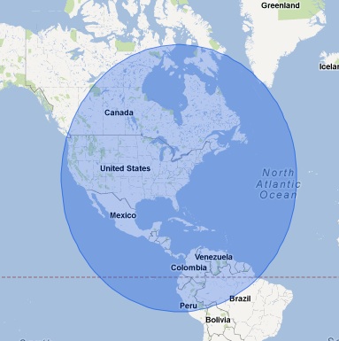
Let’s move to Jupiter. One can see that all of Central America and a big chunk of South America are closer than Neah Bay. As I looked a little more carefully it demonstrated that even a section of Bolivia was closer (we’ve discussed that one before).
Point Arena
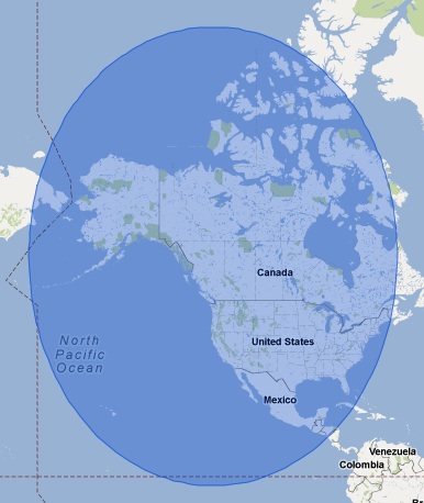
Next I examined the longest absolute line. There, Point Arena, CA demonstrated similarly confounding elements. The circle included Honduras, Hawaii, Alaska, all of Mexico, most of Canada and parts of Cuba and the Bahamas. They are all closer to Point Arena than it is to West Quoddy, ME.
West Quoddy
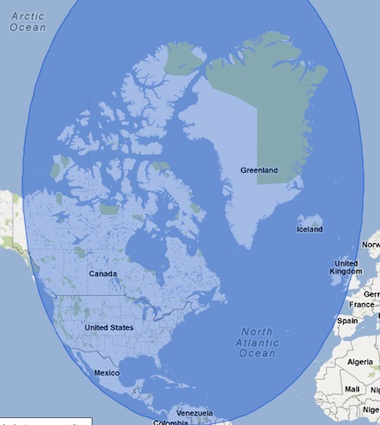
Finally, I turned my attention to West Quoddy and performed the same examination. This one might be my favorite. The circle contained the usual suspects including Central America, Greenland and most of Canada. However it also crossed the Atlantic Ocean.
There it clipped a segment of Portugal, a tiny corner of France near Brest and incorporated most of Great Britain. West Quoddy is closer to all of these places than to Point Arena. For the United Kingdom specifically, all of Northern Ireland, all of Scotland and nearly all of Wales are closer. Plymouth, Cardiff and Manchester are closer. Bristol, Birmingham and Leeds are farther.
There’s no special meaning to these observations. I’m just having a little fun today.
Leave a Reply