
I love circles, which I guess would be an entirely redundant statement on Twelve Mile Circle. I’ve been toying with a concept in the back of my mind for awhile. What it the smallest circle that I can draw on a map that touches the largest number of countries? Google Maps doesn’t offer such a tool and I felt guilty after I badgered them for something like two years to get county lines, so I let it slide. Still, I wanted to know.
There are radius tools designed by private software developers using the Google Maps application programming interface (API). However I kept hoping Google would cave-in and develop one themselves. It hasn’t happened. Finally I turned to one of the outsider tools. Thus, the maps today are not embedded or interactive in any way. They are screen prints. You can’t click on them. Well, you can but they won’t do anything.
Four Nations
It made no sense to ponder the smallest circle touching one, two or three nations. That’s just silly. I began my quest by examining four nations instead. I can’t promise I found everything. Hopefully this will get the ball rolling so that others can build upon my platform
The best example I could find was Botswana, Namibia, Zambia, and Zimbabwe. One can draw a circle with a radius of perhaps a tenth of a kilometre touching all four countries where the Kazungula Ferry crosses Zambezi River (map). It might even be a quadripoint. Nobody is completely sure and it would entail definitive surveys by all four nations. I’m not going to spend much more time on this topic because I covered it previously on What Happened to the Handle?. I will add one editorial comment though: this spot is high on the list of places I’d love to visit someday.
I’ve also discussed the second best example I found, a radius of 1.5 km touching Armenia, Azerbaijan, Iran, and Turkey (map) in Fictional Geo-Marathons. Ditto for the third, a radius of 17 km touching Austria, Germany, Lichtenstein, Switzerland centered on Diepoldsau, Switzerland (map).
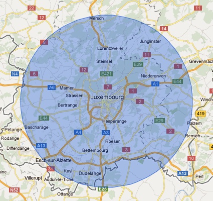
Tied for third, with a 17 km radius, finally I can print a new map. The four nations are Belgium, France, Germany, and Luxembourg, centered practically right atop Luxembourg City. I’ve been to Luxembourg a number of times. It’s a nice place, and indeed it’s a convenient way to hit a number of nations with minimal effort. I took a ridiculous trip for that very purpose once and I’m not embarrassed to admit it.
I found a few other examples.
- 22 km radius: Algeria, Mauritania, Morocco, Western Sahara (albeit Western Sahara is disputed)
- 25 km radius: Israel, Jordan, Lebanon, Syria
- 32 km radius: Austria, Italy, Lichtenstein, Switzerland
Five Nations
Then I turned my attention to five nations. The overly-fragmented situation of the Balkans provided plenty of opportunities to examine possibilities
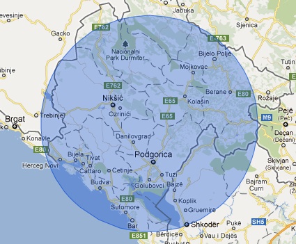
The best instance I could find was a circle with a radius of about 70 km touching Montenegro, Bosnia & Herzegovina, Croatia, Serbia, and Albania. For added drama, and depending on whether one recognizes Kosovo, the same circle might be said to touch six nations!
This was followed closely by a radius of 80 km that included Djibouti, Eritrea, Ethiopia, Somalia, and Yemen. This one was fun because the final nation was found on the other side of the Red Sea. That’s where the circle picked up Yemen.
It was around that time that I began to lose interest in my circle game. Obviously one could use the tool to see if better examples existed or to extend the game to larger numbers of nations. I was thinking that perhaps various Caribbean islands might be a possibility.
Leave a Reply