
Geography and history dominate southeastern Kentucky. Those were primary reasons for my selection of this corner of Kentucky when I decided to feature it as my U.S. State of Focus(¹) during the Summer of 2013. Twelve Mile Circle concentrates foremost on geography. However, one never avoids history here completely either. The two went hand-in-hand during our latest adventure.
The Hensley Settlement
Notice the light green patch of vegetation surrounded by the much darker forest. That’s part of the the Cumberland Gap National Historical Park. It was also once the Hensley Settlement. Feel free to open the image in another tab and toggle between satellite, street and terrain views. Those will help you gain a better appreciation of its remoteness. The settlement occupied a gently rolling plateau atop Brush Mountain. Steep terrain and a lack of roads separated it from the outside world.
Visiting
I learned about the settlement while searching for things to see in the park. Two options existed, a multi-mile hike over rough trails or a daily guided van tour provided by park rangers. Our young kids could handle short jaunts of moderate difficulty. They did not have the physical stamina for long hikes through the backcountry.
Few people get an opportunity to experience the historic Hensley Settlement because of its isolation and limited access. We called the Cumberland Gap visitor center several days in advance and signed-up for a tour, making sure we reserved spots in their 15-passenger van. The rangers might bring two vans up the mountain on particularly busy days. So the maximum number of visitors is 30 per day plus whoever may happen to hike there on foot.
The van followed Shillalah Creek as it climbed Brush Mountain on a rough gravel Park Service road. It’s blocked by a locked gate ordinarily and unavailable to regular drivers. The road was so steep and winding that our ranger radioed ahead to make sure nobody was coming down. Then it took him half an hour to drive the four or five miles to the mountaintop.
Some History
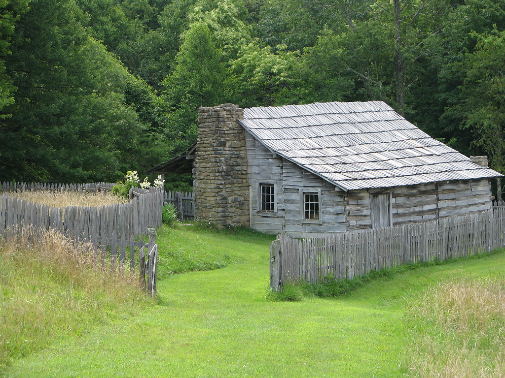
We arrived at the Hensley Settlement and walked through the grounds with the ranger. There we learned about the significance of each cluster of farms and buildings. About a hundred people lived there from the beginning of the 20th Century until the Second World War. That’s when young men drafted into the Army experienced the outside world. They saw better lives and easier opportunities elsewhere. The last resident left the Hensley Settlement in the early 1950’s.
This completely self-reliant community flourished for half a century. Even so, it had no electricity, no running water, no telephone, no radio, no motorized machines, and precious little access to the outside world. So this was truly Appalachia. Hensley settlers demonstrated amazing resourcefulness in the homes they built and the ingenious devices they produced with their own hands.
Founded by two interrelated families, Hensley and Gibbons, residents farmed the hilltop and occasionally hiked down to the valley to barter for whatever scant necessities they could not produce on their own. The trip to the nearest town took an entire day. Generally this wasn’t an issue except for medical care. They suffered horrific child mortality rates and their cemetery filled with the graves of their young. However, if residents made it to adulthood they enjoyed a solid shot at decent longevity.
Blue Heron Mining Community
Another community formed farther west — equally intertwined with Appalachian history albeit in a different way — extracting massive seams of coal formed along shallow tropical seas hundreds of millions of years ago. Blue Heron was a coal mine (map). It was also a company town. Today its remnants form part of the historic Blue Heron Mining Community in the Big South Fork National River & Recreation Area.
Background
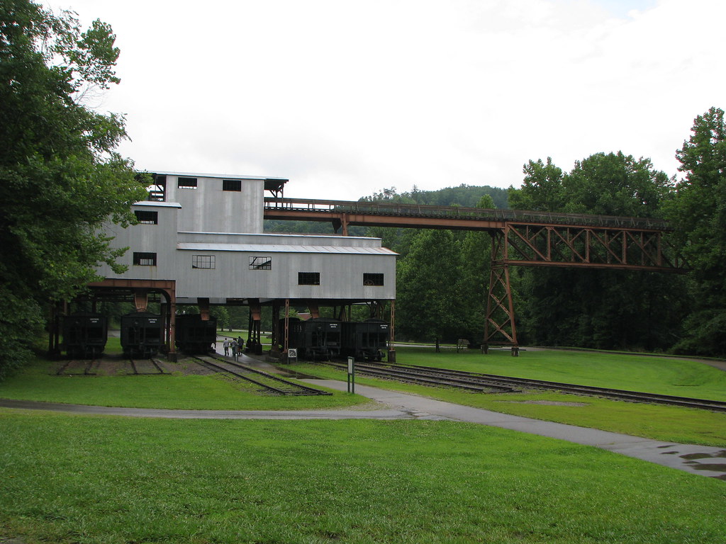
Justus Smith Stearns was a timber baron from Michigan. Eventually he purchased large tracts near the present town of Stearns, KY in the early 20th Century. His Stearns Coal & Lumber Company exploited his holdings, building various mining camps and communities throughout his private domain.
Blue Heron, or Mine 18, was one of the most technologically-advanced coal mines when it opened in 1937. Coal extracted from the surrounding mountains went straight into a tipple. Then it dumped directly onto rail cars and left the state. The mine would operate profitably for the next quarter century before shutting down.
Visitors today can reach the historic park by automobile. During its heyday, however, one could arrive solely on the Kentucky and Tennessee Railroad constructed by Stearns Coal & Lumber. Blue Heron was a noisy, dirty, busy, and yet completely isolated company town on the Big South Fork of the Cumberland River. Blue Heron backed-up to coal mines on one side and an industrialized railyard on the other. It was all about extracting coal quickly and efficiently with little concern for creature comforts.
Scenic Railroad

Visitors can still ride the train to Blue Heron albeit much more relaxed than one would have experienced mid-Century. The Big South Fork Scenic Railroad followed the same set of tracks from Stearns depot down into the gorge and through a tunnel, hugging the side of a mountain with scenic views of a swiftly-moving river, past the old Barthell Coal Camp, and finally into Blue Heron. The round trip, including about an hour and fifteen minutes in Blue Heron, took three hours. It was a slow, laid-back ride so it’s best to sit back and appreciate it for what it offers. This is not intended as a thrill ride.
Here’s a travel tip that a railfan passed along to us as we waited to board in Stearns: Sit at the back of the train on the left side (as you are facing forward towards the engine). This provided the best scenic vistas along the route. It also allowed us to photograph the train as it chugged around curves.
Cumberland Falls
Cumberland Falls has been a long-standing tourist attraction (map). Visitors in the 1880’s would have stopped at this same spot to appreciate the magnificence of the Cumberland River’s dramatic 68 foot (21 metre) drop. It’s sometimes called the “Niagara of the South.” It’s not. It’s nothing like Niagara. I’m sure the falls were dubbed such by an overzealous tourism promoter a hundred years ago. Cumberland Falls is still impressive and absolutely worth visiting. However, I don’t have much patience for anything described as an “of the” this-or-that. Let’s allow the falls to stand on its own and bask in its natural beauty.

Someone in the late 1920’s had the bright idea to dam the Cumberland River farther upstream. Unfortunately that would have threatened Cumberland Falls. So it prompted Thomas Coleman du Pont, of that du Pont family and president of the Company of the same name, to purchase the surrounding land in 1930. His wife donated these holdings to Kentucky after he died. Fortunately it’s now protected as Cumberland Falls State Resort Park as a nice bit of philanthropy.
The odd color of the water in the photo, by the way, was the result of a thunderstorm that hit before our arrival. Somehow we managed to thread-the-needle between storms and visit the falls without getting wet.
Kentucky Adventure articles
12MC Loves Footnotes!
(¹) It’s actually the Commonwealth of Kentucky if one wishes to get technical on that point; one of four U.S. states to use that distinction. I’ll continue to reference it as a “state” and include this little footnote so nobody feels a need to request a correction.
Leave a Reply