
Recently I got to thinking about what may have sparked my original interest in geo-oddities. I’m not sure what caused me to suddenly ponder this topic but I do have a ready answer. Like many of you, I recall numerous childhood hours spent happily pouring over maps, fascinated by the overlay of abstract lines upon the tangible features of the larger world around me. There was a deeper dimension to my fascination however with solid roots in the physical landscape itself.
The Layout
I spent my elementary school years in a house that backed up to woodlands.
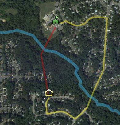
It’s a bit difficult to picture where I grew up from a recent satellite image. So much has changed. Imagine that everything to the left of the yellow house, my early home, does not exist. Replace it with a meadow and an active farm with cornfields. The blue line running diagonally across the image? That’s a creek. The red line? A shortcut through the woods to my elementary school. The yellow line? The “approved” path to school using public roads and a pedestrian walkway across the creek. A gently hillside rolled down from the house towards the creek, a little valley of sorts.
The Pipeline
There is also a faint line through the woods heading northeast from the house. That is a right-of-way for the Colonial Pipeline.
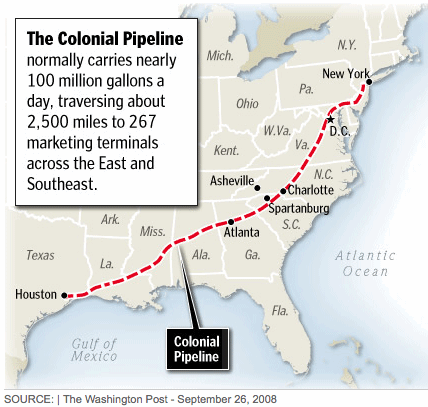
As explained on their website, “Colonial delivers 100 million gallons a day of refined petroleum products. These are liquids: gasoline, jet fuel, diesel fuel, home heating oil and fuel for the U.S. military.” I’m not sure how that’s relevant to this article other than it helps to demonstrate the variation of the terrain we explored, and it sounded really cool. Until this moment I didn’t know exactly what gushing under our feet. It’s a good thing we never tried to dig it up.
Free Range Kids
We practically lived in the woods and meadows and fields. We created dams and canals on the creek, built tree houses in the oaks, dug trench forts in the reddish clay, blazed trails over the hills, and climbed, crawled, hid and ran through every corner of every acre.
That was back when adults let their children run around all day until sundown without supervision. I can’t imagine letting my children do anything similar today although I don’t think the world is appreciably more dangerous than it was back then. Society has changed and apparently I’ve changed along with it. Someone would probably call the Child Welfare authorities on me too.
Reaction to Change
That freedom to explore, however, didn’t create the spark on its own. That began to happen when the county government built that pedestrian bridge across the creek. Until then we took a bus to school every day, a distance of 2.7 miles over surface roads. The bridge created a 0.9 mile walk to school, just short enough to push us off the bus and force us into a march each day. We already knew, however, that a walk through the woods was considerably shorter. It came out to 0.3 miles when I measured it in Google Earth this evening. Three times shorter creates a powerful incentive.
This created a competition between kids that wanted to minimize their walk and authority figures who felt the woods were dangerous. Their knowledge of the terrain didn’t come close to matching ours but they held an advantage at the terminus, the school. Usually it was easier to take the shortcut leaving from school in the afternoon than attempt to arrive that way in the morning. It was clear sailing if one could make it past the baseball field and into the woods.
I’m pretty sure it was that ongoing cat-and-mouse game that pushed me to focus on topography and mapping. Every since then I’ve been fascinated by odd features, alternate paths, and finding ways around the system. My interest in geography traces back to my laziness.
What is your geography story?
Unrelated Topic
There was an interesting article on the New York Times website recently: “A Bypassed Small Town Makes a Visual Statement: Here We Are.” It’s a light human-interest story about a town that erects a monument so that people driving by will see that something exists there.
Leave a Reply