Gaithersburg Doughnut Hole

I’ve noted my appreciation for reader comments, suggestions and input on many occasions. The quality of what people contribute is nothing short of miraculous. Sometimes an example lodges in my brain to the exclusion of all the rest. That’s what happened with the Gaithersburg Doughnut Hole and I don’t know why. It’s not any more elaborate or unusual than other geo-oddities contributed by viewers. I’m fixated though and I can’t resist it. I needed to learn more.


Doughnut or Donut?

Reader “Matt” submitted a comment on the recent Arapahoe Exclaves in Denver article. He focused on Ohio but then he said, almost as an aside, “Also, Gaithersburg, Maryland, looks like a doughnut with a big hole in it.”

I set-aside thoughts of Ohio for some future article and focused my energies on Maryland. Maybe it’s because I like doughnuts, or is it spelled donuts? I think both variations are supposedly acceptable. Or maybe because it’s just around the corner from where I live? Either one is equally likely.

Gaithersburg, Maryland is a suburb of about 60,000 people located towards the northwest of Washington, DC, outside the Beltway along Interstate 270.


Totally a Doughnut

The various online maps did not provide decent municipal boundaries until recently so I cross referenced it with other sources to truly appreciate Gaithersburg’s remarkable doughnut-shaped configuration. I never doubted its existence — the readers of the Twelve Mile Circle demonstrate my woeful ignorance daily — instead I wanted to determine its exact shape and reason for being.


Examining the Situation

The City of Gaithersburg’s official zoning map provided plenty of plausible explanations for both… well, mostly.

Gaithersburg Doughnut.  Source: City of Gaithersburg

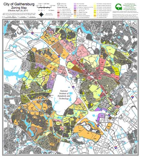
The preponderance of excluded interior territory has a single owner, the United States federal government. It’s the sprawling headquarters campus of the National Institute of Standards and Technology, or NIST. Wikipedia thinks that NIST is headquartered in Gaithersburg but it’s wrong. It’s a sham. Gaithersburg gets all the prestige of NIST which actually sits within an unincorporated area of Montgomery County completely surrounded by the city. In their defense it does have a Gaithersburg mailing address.

I’m not an expert on taxes but I believe it would be difficult if not impossible for a city to impose a real estate tax on a federal government entity. Keeping NIST “outside” of Gaithersburg would seem to make good economic sense if that’s the case. The city wouldn’t have to serve a group that doesn’t pay them taxes in return. It wouldn’t make sense to provide their city services for free.


An Exception

There is another area of the doughnut hole that isn’t part of NIST. It’s a small triangle of land defined by I-270, Muddy Branch Road, and West Diamond Avenue.

The triangle seems to include a number of large apartment buildings with a few single-family residential units on the periphery. Businesses contribute more to the tax base than residents. Excluding a few high-density dwellings collocated with the NIST tract would benefit the remainder of the city. Apparently that’s exactly what they’ve done.

Mmm… donuts. Apparently that IS the fixation. My apologies to Homer Simpson — it’s not the only trait we share in common.


Posted

in

, ,

by

Comments

7 responses to “Gaithersburg Doughnut Hole”

  1. Alex Avatar
    Alex

    America’s frayed-edge municipalities are indeed fascinating. You don’t see that sort of fractal bordering elsewhere, and I think I know why. The concept of cities “incorporating” is one unique to the USA, I think. It’s very much a bottom-up affair, whereas municipal units in other countries are usually determined top-down, by a higher level of government.

    This tends to mean two things: 1. all territory is covered by municipalities, so there’s no virgin ground for cities to expand into so haphazardly, and 2. the borders are a lot straighter!

    Compare the USA’s counties, which to my knowledge are top-down creations of the states, have much more regular borders, and tend to cover the whole state without gaps. These are comparable to municipalities elsewhere in the world. Incorporated cities that are laid down on top of the counties whilst not being subdivisions of that layer, and grow piecemeal leaving enclaves and other oddities, are not generally seen elsewhere.

  2. Randy Clark Avatar
    Randy Clark

    DeLorme shows this latter area as the Londonderry neighborhood. Though it’s the same shade as the rest of G’burg I’m a bit unclear as to whether the shading is the town area or the zip code.

    1. Joshua Avatar
      Joshua

      According to http://www.usnaviguide.com/zip.htm, the triangle area seems to be in the 20877 zip code, as opposed to the NIST being in 20878.

  3. Joe Avatar
    Joe

    Just learned some background on an interesting “border war” that I thought I would share. In the 1830s, Missouri and Iowa fought the “Honey War” over the border of the states, with most of the action occurring along the eastern edge of the border (SE Iowa and NE Missouri). As a result, the US Supreme Court eventually settled the official boundary which was then marked with markers every 10 miles. Missouri recently had a surveyor attempt to find each of the old markers, and did locate most of them. I’ve been searching to find a list or map with the actual marker locations, but have been unable to find one thus far.

    1. Twelve Mile Circle Avatar

      Wikipedia has a pretty good overview of the Honey War, too: http://en.wikipedia.org/wiki/Honey_War

      1. Joe Avatar
        Joe

        Yes that was one of my first stops for information once I learned the “Honey War” existed. There are several articles and sites with great history and information on the war, but I still can’t find any info on the locations of each 10 mile marker. 🙁 Anyway, I find the story pretty interesting and thought I would pass it on to you.

  4. Cyrus Avatar

    Curious as to whether the county or the city provides services to the numerous residents who live in the unincorporated triangle inside the donuthole….

Leave a Reply

Your email address will not be published. Required fields are marked *

Latest Comments

  1. Technically it’s not always correct to say EST/CST, etc…. but just an indication that I’m changing time zone is enough,…

  2. In general, I wonder why navigating from the Atlantic Ocean to the Black Sea doesn’t count as inland navigation.

  3. Re: East/West Carroll parishes, you’re close, but the real reason for the split was more political than demographic or cultural.…