The Oddity That Got Away

I’ve returned from Denver, Colorado.

Well of course I found some time to record a couple of oddities. That’s what I do. Specifically I visited the Denver International Airport and one of the Arapahoe Exclaves. However, I didn’t exhaust the wish list I brought along with me. Maybe I should have expected that because I was a bit too ambitious. I didn’t have much time each evening and little flexibility with my schedule during the day.

So I thought I’d share one final big-ticket item I wanted to document in person. Unfortunately it will have to wait for a subsequent trip.


One Mile

Denver’s nickname is the “Mile High City” for an obvious reason. Look around and you’ll notice its elevation is indeed right around one mile or 5,280 feet (or 1,609 metres). This is quite evident as soon as an Eastern flatlander such as myself walks up a flight of steps on the day of arrival encumbered with luggage. I’d like to think of myself as being somewhat in shape and preferring to take the stairs for short distances. Even so, next time I’ll use the elevator until day two or three. It takes awhile for my brain to adjust to thinner oxygen at these higher altitudes.

I wanted to confirm Denver’s mile-high claim by examining evidence available on the ground. I’m not doubting their assertion because the altitude is completely self-evident. It’s not an exaggeration or a marketing ploy. Rather I wondered whether anyone had ever memorialized this exact height on the physical landscape. It’s such an interesting little tidbit. I figured the local tourist board must have put up a sign or a plaque to amuse the visitors.

The Search

I stared with a quick Google search on the phrase, “exactly one mile high.” That provided a good starting point with some solid candidates. Practically everything tracked back to Denver with the exception of a swinging bridge on Grandfather Mountain in North Carolina. I also wouldn’t mind visiting that someday but let’s get back on point. The difference is that in Denver everywhere is about a mile high, not just some out-of-the way park requiring a long drive and an admission fee.

Incidentally there are zero Google hits for “exactly one kilometer high”, and yes I do realize that I’ve just ruined that by publishing this post. I suppose this happens because a kilometre of elevation isn’t all that remarkable (3,281 feet). Or maybe this particular style of geo-oddity doesn’t resonate outside of the United States. Are there any armchair sociologists out there who want to offer an explanation or a theory? I have none.

However, there are at least two places in Denver — both easily accessible — that mark the mile-high elevation exactly and explicitly.

The State Capitol

Mile High City. Photo by notevenathing; (CC BY-ND 2.0)

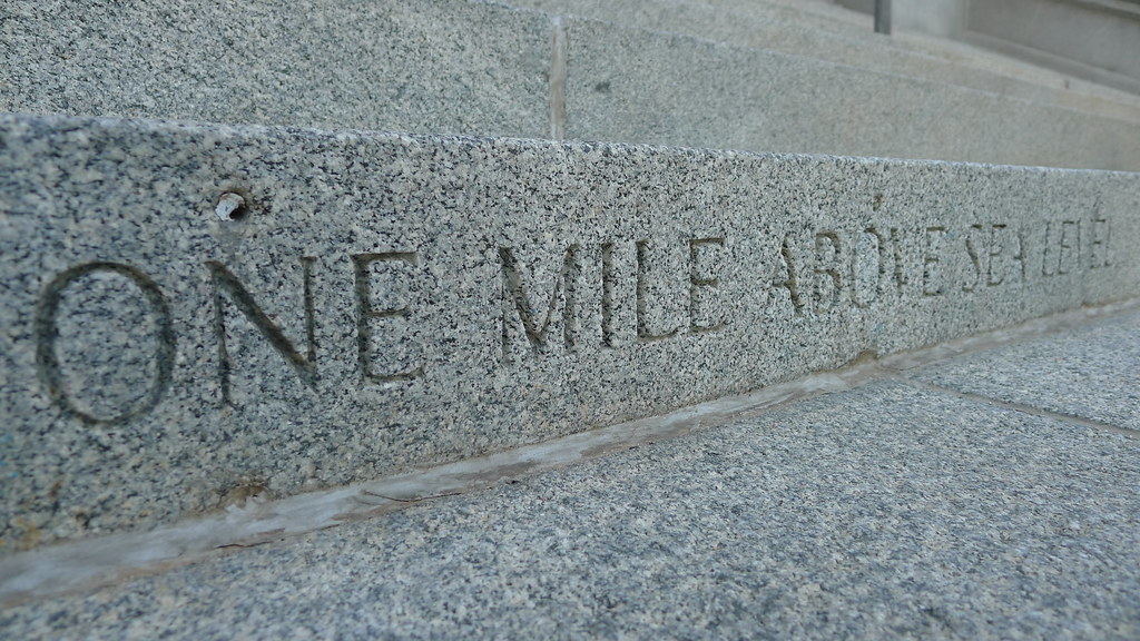
The first location is the thirteenth step of the Colorado State Capitol building (map). I’m kicking myself for this one. I spent an entire week in downtown Denver a couple of years ago and didn’t realized this marker existed. It would have been so simple for me to record. This time I stayed way out in the suburbs. Unfortunately I didn’t have an easy way to get down there.

Coors Field

This purple row of seats at @Rockies Coors Field in #Denver is exactly one Mile High. Photo by Paul Thompson; (CC BY-ND 2.0)

Another opportunity would have been available at Coors Field, home of the Colorado Rockies baseball team (map). The Rockies were in town, we had some beautiful weather, it would have been a great night for baseball. And again… I was way out in the ‘burbs.

The seats in the 20th row of the upper deck are purposely colored purple. This purple row creates a band around the stadium at the mile-high mark. This provides a more literal interpretation to the term “nosebleed section” than most of its major league counterparts.


Shifting Gears Just a Little

I noticed a peculiarity as I panned around the map of Denver while preparing this recent series of articles. Check this out:

Does anyone know of a smaller occupied area completely surrounded by Interstate highway? This triangle, probably no more than a mile on any side, is enclosed by Interstates 25, 76 and 270. There are plenty of paths in-and-out so it’s not exactly isolated but I still find it fascinating. I can’t imagine how noisy it must feel with those highways running so closely on every side. This patch is primarily non-residential (except for maybe these guys) which is probably a good thing.

I’d be interested to know if someone can find a smaller enclosed area where the space is actually being occupied, either for business or residential purposes, that doesn’t involve an instance of someone refusing to sell their property when the highway comes through, i.e., a planned route rather than an individual accommodation.

Comments

16 responses to “The Oddity That Got Away”

  1. Randy Clark Avatar
    Randy Clark

    As A Rockies fan I thought everybody knew about the stadium row. Keep up with my team by following the blog:
    http://www.purplerow.com/

    Go see a game. Lots of excitement but no vuvuzelas.

  2. Scott Schrantz Avatar

    Maybe it doesn’t count because one of the freeways is not an Interstate, but:


    Supposedly the “busiest freeway interchange in the world”, according to Wikipedia.

    http://en.wikipedia.org/wiki/East_Los_Angeles_Interchange

    1. Twelve Mile Circle Avatar

      @Scott Schrantz: I’d say it qualifies, and wow, what a bleak situation. It’s no wonder that only a couple of warehouses and what looks like a junkyard are located within that tangled mess!

  3. Bill Cary Avatar

    Until I saw the comment above I wanted to tell you about the Lockland split on I-75 on Cincinnati’s north side. The roadway is elevated through that area and it splits to go around the Lockland community with houses and streets inside the north bound and south bound lanes of I-75. To me the area always seems bleak, depressing, and dire as all points from the town’s center lead to an interstate highway which separated the town from the environment. It evokes a snowglobe type of existence.

    I-24 also splits on Monteagle Mountain just northwest of Chattanooga but I do not know if anyone lives inside the split roadways.

  4. Taber Avatar

    This hardly matches either of the above areas for sheer surrounded-ness since the area is a bit larger, but I immediately thought of the couple block wide area here in my city of Richmond, Virginia between the Downtown Expressway (VA-195), Powhite Parkway (VA-76), and I-195. Included is a significant residential area and the former football stadium for the University of Richmond.


  5. Guy Granger Avatar
    Guy Granger

    Beat This!

    I don’t know if it still exists, but in Milwaukee, Wisconsin there was an interchange built around a single building, the Aldrich Chemical Building. It sat at the interchange of I-794 and I-43! You can see it on this google map:
    http://bit.ly/9VqHxw

    I hope that works. If not, just go to google maps and type in the address: 1001 W St. Paul Street, Milwaukee, WI. I can confirm that it was occupied by the workers, who I used to wave to as I drove back and forth to work for almost ten years.

    1. Twelve Mile Circle Avatar

      @Guy Granger: The Google satellite image shows the building but Street View shows this:


      Uh oh, it looks like it’s been demolished! That’s a shame too because I go to Milwaukee frequently and I never knew this anomaly existed. Now I’ll never get a chance to check it out…

  6. mike Avatar
    mike

    There’s a hotel in Pittsburgh:


  7. mike Avatar
    mike

    Don’t know if this counts, but:


    1. Harry Berman Avatar
      Harry Berman

      Notice the parking lot across the street below the bridge at exit 1B / 1C 2 the entrance aisle there are dots on the pavement . Those dots are 3rd. base and 2nd base at the sight of the first World Series between Boston and Pittsburgh .

      https://www.google.com/maps/@40.4466747,-80.0102829,63m/data=!3m1!1e3?hl=en-US

  8. James D Avatar
    James D

    Not in the USA, so not technically an Interstate, but I think this farm between the two carriageways of the M62 motorway in the north of England is hard to beat:


  9. Joe Greene Avatar
    Joe Greene

    Not very impressive, but there’s a lot of houses between all of these very congested highways in Durham, NC.


  10. Dale Sanderson Avatar

    There have actually been three different mile-high markers on the Capitol steps, because of refinements over the years in the way elevation is measured. See this page for more info:
    http://mesalek.com/colo/trivia/elev.html

  11. Hamish Avatar
    Hamish

    I have been thinking about this post for a while. There is a building Vancouver which is surrounded by the off ramp from the northbound lanes on the Granville Street bridge. It is some sort of a rooming house – I have sat in traffic and looked into people’s windows.

    You can see an aerial view here:


    But that isn’t the best part. The building is well known in Vancouver because of the giant mural of Killer Whales on the side that was painted some 20 years ago and is what you see entering the city over the bridge.


  12. Greg Avatar
    Greg

    Muskogee, OK, appears in Google Earth to have highly idiosyncratic borders, including several flagpole annexations that don’t go anywhere but just die out without widening to encompass anything.

Leave a Reply

Your email address will not be published. Required fields are marked *

Latest Comments

  1. Technically it’s not always correct to say EST/CST, etc…. but just an indication that I’m changing time zone is enough,…

  2. In general, I wonder why navigating from the Atlantic Ocean to the Black Sea doesn’t count as inland navigation.

  3. Re: East/West Carroll parishes, you’re close, but the real reason for the split was more political than demographic or cultural.…